Regional Disparities and Opportunities for Agricultural Growth: A spatial Analysis about Jhunjhunu District of Rajasthan, India
Shyam S. Khinchi 1![]()
![]() ,
Amit Kumar 2
,
Amit Kumar 2![]()
![]()
1 Professor,
Department of PG Studies in Geography, Dr. Bhim Rao Ambedkar Government
College, Sri Ganganagar, Maharaja Ganga Singh University, Bikaner, Rajasthan,
India
2 Research
Scholar, Department of PG Studies in Geography, Dr. Bhim Rao Ambedkar
Government College, Sri Ganganagar, Maharaja Ganga Singh University, Bikaner, Rajasthan,
India
|
|
|
ABSTRACT |
|
|
Analyzing
agricultural progress and opportunities in Rajasthan, India's Jhunjhunu
district is the primary goal of the present research. Agricultural planners,
social workers, and officials carrying out development projects can learn
from the study. The intention is to make recommendations in order to properly
construct a plan for agricultural development and opportunities in the area
under consideration. The current study's research aims have been maintained
in light of these. In India as a whole, it is currently getting harder to
keep up traditional core business in a timely and balanced manner. In
actuality, agriculture is a business that is affected by the environment.
However, the Jhunjhunu district in Rajasthan, India, has seen more pollution
and impacts from human activity than any other business. The regional
disparity in agricultural growth has been evaluated within the framework of
Jhunjhunu district, taking into account geographical factors. This study
emphasizes the significance of sustainable land management practices in the
Jhunjhunu area of Rajasthan, India, in order to address regional disparities
and investigate prospects for agricultural development |
|||
|
Received 07 August 2025 Accepted 10 September 2025 Published 06 October 2025 Corresponding Author Shyam S.
Khinchi, shyamskhinchi253@gmail.com DOI 10.29121/granthaalayah.v13.i9.2025.6365 Funding: This research
received no specific grant from any funding agency in the public, commercial,
or not-for-profit sectors. Copyright: © 2025 The
Author(s). This work is licensed under a Creative Commons
Attribution 4.0 International License. With the
license CC-BY, authors retain the copyright, allowing anyone to download,
reuse, re-print, modify, distribute, and/or copy their contribution. The work
must be properly attributed to its author.
|
|||
Keywords: Agricultural Growth, Spatial Analysis, Regional Disparities, Agricultural Sector |
|||
1. INTRODUCTION
India has traditionally been a farming nation. Currently, agricultural development makes a significant 16.38% contribution to the nation's gross domestic product. The agricultural sector provides a living for almost 70% of the population. Agriculture is clearly impacted by numerous environmental and cultural elements. As a result, the diversity of agricultural development may be seen across the globe. In addition to providing the majority of the rural population's income and means of commerce, agricultural development is the cornerstone of the rural economy and industrial raw materials. Thus, from a socio-economic and developmental perspective, agricultural development is crucial for the state's population and economy.
Since the beginning of time, geography students have studied the interaction between agriculture and humans. The global community is currently dealing with numerous intricate social and economic issues. Given the complexity and scope of these issues, the population is growing quickly in today's societal development. Conversely, the agriculture industry is steadily contracting. Issues such as food insecurity, food crises, starvation, and natural disasters like floods and droughts may become less impactful as agricultural growth rapidly accelerates and agricultural output gradually rises. A region's or nation's economic development is significantly impacted by the rate and form of agricultural development.
Population, agricultural productivity, and agricultural development all have an impact on one another, which makes their joint study imperative. The global population is growing at a faster rate than in the past. It is predicted that over the first two decades of the twenty-first century, it will approach 8.5 billion. India's population density places a great deal of strain on agriculture. New agricultural technology has been developed as a result of research in the agricultural sector, aiming to feed the growing population and boost its economic status. The Green Revolution led to the modernisation of agriculture through the use of better seeds, chemical fertilisers, pesticides, and machinery, and this process is still ongoing. A further factor driving the pace of agricultural development is the shift from food crops to commercial and industrial crops. As a result, it has also been estimated that agricultural productivity has increased. Food security is one benefit of the shift in the agricultural sector, but there is also a clear drawback in terms of environmental damage. Numerous issues are being brought about by this, including deteriorating land quality, biodiversity loss, unbalance in the food chain and web, biomagnification, rising greenhouse gas emissions, acid rain, rising environmental pollution, and declining groundwater levels. While their effects right now are not very frightful, they are a sign of a major issue that may arise in the future. Consequently, the ecology as a whole will lose its equilibrium. This will have an impact on human life as well as the entire living world. Development in agriculture is required to regulate it.
2. Review of literature
Agricultural land conversion drivers: A comparison between less developed, developing, and developed countries was published in 2011 by Azadi, H., et al. They were utilising a stratified random sampling technique and taking into account the World Bank's classification to look at the primary drivers of agricultural land conversion (ALC) globally. They acquired their data from Earth Trends and Nation Master, two databases. The groups' ALC trends and intensity levels varied somewhat, according to the empirical findings. Loss of agricultural land was more severe in developing nations going through fast economic expansion and structural changes Azadi et al. (2011).
The study "Space, Time, Rhetoric, and Agricultural Change in the Transition Zone of Ghana" was published in 2007 by Amanor, K.S. and Pabi, O. They looked at how farming systems changed and how agricultural mechanization and modernization affected local farming systems and the surrounding economy. It documents changes in farming practices, land use, and land cover by combining historical, ethnographic, and remote sensing methodologies Amanor and Pabi (2007).
A study conducted in 2022 by Feliciano, D. examined the factors that influence the implementation of sustainable agriculture techniques in seven horticulture farms located in the United Kingdom. Farmers demonstrated a clear understanding of the value of soil, and governments should support their participation in soil health monitoring to involve them in the larger conversation about the application of sustainable land management, which includes mitigating and adapting to climate change Feliciano (2022).
The article Population-Driven Changes in Land Use in Developing Countries was discussed by Bilsborrow and Okoth-Ogendo (1992). It was revealed that land use variables act as intermediaries between demographic dynamics and land degradation. They contend that a comprehensive understanding of the ways in which population growth and redistribution impact deforestation, soil erosion, and other problems requires a close examination of changes in land-use patterns across time. These changes, which include adjustments to land-tenure arrangements, land intensification, and land extensification, are seen to manifest in a variety of ways, depending on institutional factors and natural resources, according to framework presented Bilsborrow and Okoth-Ogendo (1992).
Beyond land cover change towards a new generation of land use models was the subject of research by Verburg et al. in 2019. They have mentioned how land use models are crucial for integrating knowledge in land system science and for investigating the dynamics of future land change. However, only modest progress has been made towards achieving these objectives because of insufficient model evaluation and representation of the underlying socio-ecological systems. They examine how land use models can more properly capture human agency, demand-supply interactions, and multi-scalar dynamics, and how to learn from model evaluation. By addressing these issues, we open the door for the creation of a new generation of land use models that will facilitate the assessment of future changes in land cover patterns as well as the encouragement of society to envision land use, which will promote the development of alternative solutions and sustainable solutions through discussion and ideation Verburg et al. (2019).
Khinchi (2018) talked on agriculture, which they claimed was the district's main source of income. Thus, land and agriculture are extremely important. The land is in bad shape over a big portion of it. which, with agricultural improvement, can be used for agriculture Khinchi (2018).
Khinchi (2020) examined the relationship between agriculture and the environment, highlighting the region's reliance on agriculture while also examining farmer concerns and innovative agricultural practices tailored to local resources and environmental circumstances Khinchi (2020).
Dynamic Trends in Land Utilisation: A Case Study of Sawai Madhopur District, 2017–2022 was published in Meena and Khinchi (2023) assessment. Over a five-year period, from 2017 to 2022, this study examines the dynamic trends in land utilisation within Sawai Madhopur district. By statistically examining land use data from a range of categories, including forest area, non-agricultural land, barren land, and others, they reported on noteworthy patterns and changes. The findings indicate a notable rise in the area covered by forests, a testament to successful conservation efforts, and a steady increase in the use of non-agricultural land, an indication of ongoing urbanisation and industrial growth. Moreover, declines in undeveloped land signify effective land reclamation campaigns, whereas consistency in other categories signifies consistent land management practices. In addition to the implications of these findings for environmental sustainability, rural development, and policy design, future directions for study and action are taken into account. The present study enhances our comprehension of the land utilisation dynamics in Sawai Madhopur area and underscores the importance of sustainable land management practices for the promotion of socioeconomic and environmental well-being Meena and Khinchi (2023).
Khinchi and Meena published a study in 2023 that investigated the effects of changes in agricultural land usage on social and economic growth. The study looked at how these changes affected agricultural income, social development, and economic development in Sawai Madhopur, India. Through a descriptive and analytical methodology, the research aims to understand the complex relationships between changes in agricultural land use and other socio-economic implications. The purpose of the study is to look into how agricultural land use changes impact economic development, how these changes relate to social development, and how these changes impact agricultural income. As part of the study's methodology, data from 300 agricultural landowners and stakeholders in Sawai Madhopur are examined using structural equation modelling (SEM). There are significant associations between changes in agricultural land use and social, economic, and agricultural income, per the parameter estimates obtained from the SEM analysis Khinchi (2023).
3. Problem Statement
In India as a whole, it is currently getting harder to keep up traditional core business in a timely and balanced manner. In actuality, agriculture is a business that is affected by the environment. However, the impact of human activity and pollution has increased in this particular business. The regional disparity in agricultural growth has been evaluated within the framework of Jhunjhunu district, taking into account geographical factors. Changes in these social variables are then related to the rate of economic growth, and no evidence is found of a negative correlation between economic growth and social development King (1974).
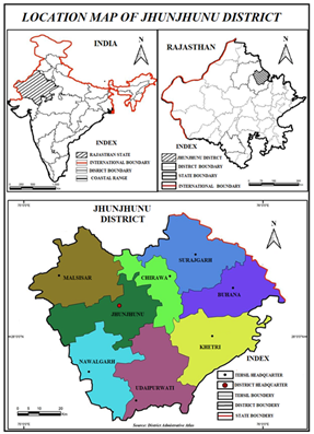
Figure 1
|
Figure 1 Jhunjhunu District, Northeast of Rajasthan State, India, is the Study Area |
The purpose of this research is to suggest technology, test it by putting it into practice at the district level, and use seeds, irrigation systems, and methods while taking changing rainfall climate conditions into consideration. The Green Revolution, along with the advancement in groundwater extraction technologies, has played a major role in uplifting agriculture and farmers’ socio-economic status in Thar Desert of Rajasthan, India Machiwal et al.. (2023).
It also aims to suggest watershed technology according to the district's terrain, the effects of these techniques, agricultural development, production, farmer self-reliance, and to suggest the use of agricultural development techniques according to the condition of un Therefore, the primary goal of this research article is to conduct a geographical comparative analysis of the following factors: geographic location, subsurface water level, agricultural productivity, small-scale irrigation techniques and their means, and the economic and social circumstances of farmers. education, management experience demonstrated by the farm manager, physical size of the farm, enterprise specialization, the use of grants, and farm location are the main factors responsible for the farmers' integration into the agro-food system Barlas et al. (2001).
The farmers of Rajasthan have been cultivating land for centuries. From generation to generation, he has been farming in this manner by synchronizing the local climate, his own needs, the fertility of the land, the availability of space, the distance from the market, the availability of credit facilities, irrigation facilities, etc. Nowadays, there is a good chance of seeing an unanticipated rise in productivity per hectare if farming is carried out using sophisticated, cutting-edge techniques and the right agricultural inputs. Three main paths of farm business development are identified in this lagging region of Greece. Conventional (mainstream) farming, alternative farm enterprise development and conventional farming with off-farm employment Damianos and Skuras (1996).
4. Introduction to the study area
In the northeast of the Indian state of Rajasthan sits the Jhunjhunu district. The district of Jhunjhunu is situated in Rajasthan's semi-desert area Figure 1. Approximately 338 meters above sea level, the Jhunjhunu district is situated in the state of Rajasthan between 75°02 and 76°06' east longitude and up to 27°38' north latitude. The hyper arid districts like Jaisalmer, Barmer, Bikaner, and Jodhpur are found at the bottom strata of overall development as evidenced by the composite indices mainly due to the bottom position of demographic, health, social, and environmental indicators for these districts Varghese (2023).
The district covers 5928 km2 in total geographic area. Malsisar Tehsil, with a total geographical area of 881.69 km2, is the largest Tehsil when seen in terms of area. Chidawa is the smallest tehsil, covering a total size of 513.52 km2.
From an administrative perspective, Jhunjhunu is currently divided into eight subdivisions and tehsils: Malsisar, Buhana, Udaipurwati, Nawalgarh, Khetri, Chidawa, and Surajgarh. The district also has 06 sub tehsils: Mandawa, Bisau, Mukundgarh, Singhana, Gudhagaudji, and Singhana. In addition, the district has eleven Panchayat Samitis: Jhunjhunu, Alsisar, Buhana, Udaipurwati, Nawalgarh, Khetri, Chidawa, Surajgarh, Singhana, Pilani, and Mandawa. In a similar vein, the district has Municipal Councils. (Jhunjhunu) and eleven municipalities (Bagad, Bisau, Vidya Vihar, Surajgarh, Chidawa, Khetri, Mukundgarh, Nawalgarh, and Udaipurwati) Khinchi and Kumar (2024), Khinchi and Tanwar (2015). A spatial analysis about Rajasthan, India are way to reviewed by Land Use Change and Agro-Climatic Interactions. In: Kumar, P., Aishwarya (eds) Technological Approaches for Climate Smart Agriculture Khan et al. (2024), Geospatial Mapping of Groundwater Potential Zones Using Multi-Criteria Decision Making AHP Approach in a Pisangan Watershed, Ajmer District (RAJ.) Yadav and Khinchi (2024), Land Use Change and Agro-Climatic Interactions. In Technological Approaches for Climate Smart Agriculture Khan et al. (2024) Furthermore, several research groups, including Impact of Climate on Agricultural Environment of North-East India: Problems and Prospects Khinchi (2015), etc., have examined this effect on various systems spatial analysis in Rajasthan.
Based on the 2011 census, the Jhunjhunu district has a total population of 2137045, or 3.12% of Rajasthan's total population. As on the 2011 census, the district's population density is 361 persons per square kilometers. Only 22.89 percent of people live in cities in this area. The majority of people in the district still live in rural areas—nearly 75% of them. Right now, this location has a 950-sex ratio and a 74.13 percent literacy rate. Men and women in the district have literacy rates of 86.90% and 60.95 percent, respectively. 1.95 percent of Scheduled Tribe individuals and 16.88 percent of Scheduled Caste residents’ dwell in the district.
5. Investigative queries
1) How has the land utilization area and reporting area changed over time?
2) What are the long-term trends in the area with uncultivated land and non-agricultural uses?
3) How has the area of desert, uncultivable land, other grazing areas, and permanent pastures changed over time?
4) What changes have occurred to the area that is covered with different tree plantations and groves over time?
6. Methodology
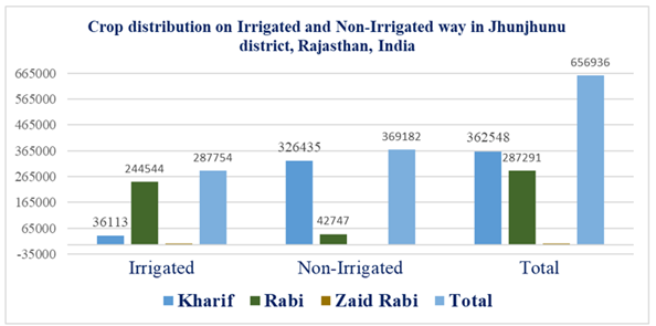
The study employs a longitudinal analysis of land use data from 2021 to 2022, covering the Jhunjhunu region. Government documents and other documents serve as the data's primary source, ensuring both quality and dependability. Crop distribution in Jhunjhunu and distribution of net irrigated lands by irrigated and non-irrigated methods in Jhunjhunu are reported in Table 1 and Table 2, respectively. Variance and crop distribution in Jhunjhunu on irrigated and non-irrigated methods Variance analysis is one of the statistical tools used to assess the significance of changes made to each land use classification. Following that, an assessment of the data is conducted in order to draw conclusions about broad trends and their potential impact on Jhunjhun land usage.
Table 1
|
Table 1 |
||||
|
S.No. |
Name of Crop |
Irrigated |
Non-Irrigated |
Total |
|
1 |
Kharif |
36113 |
326435 |
362548 |
|
2 |
Rabi |
244544 |
42747 |
287291 |
|
3 |
Zaid Rabi |
7097 |
0 |
7097 |
|
4 |
Total |
287754 |
369182 |
656936 |
7. Goals for the research project
Evaluating the agricultural progress and opportunities in the Jhunjhunu district is the primary goal of the current study. Development scheme implementers, social workers, and agricultural planners will gain insights from the study. The suggestions aim to contribute to the creation of a comprehensive strategy for agricultural potential and growth in the research region of Jhunjhunu district, Rajasthan, India.
1) To investigate historical shifts in the reporting area for land use and forest area.
2) To investigate the trends over time of the area utilised for non-agricultural uses and the land that is not suitable for farming.
3) To evaluate the evolution of arid and uncultivable land, as well as permanent pastures and other grazing regions.
4) To assess how the area occupied by different tree crops and groves has changed over time.
Table 2
|
Table 2 Distribution of Net Irrigated Lands by Irrigated and Non-Irrigated Methods in Jhunjhunu |
||||||
|
S.
No. |
Subdivision |
From
Canals |
From Ponds |
From tube wells |
From other wells |
Net irrigated area |
|
1 |
Jhunjhunu |
0 |
0 |
15748 |
7281 |
23029 |
|
2 |
Malsisar |
0 |
0 |
8074 |
3258 |
11332 |
|
3 |
Chidawa |
0 |
0 |
24 |
29246 |
29270 |
|
4 |
Surajgarh |
0 |
0 |
26917 |
32182 |
59099 |
|
5 |
Khetri |
0 |
0 |
13560 |
1948 |
15509 |
|
6 |
Buhana |
0 |
0 |
511 |
17628 |
18139 |
|
7 |
Nawalgarh |
0 |
0 |
34662 |
7727 |
42389 |
|
8 |
Udaipurwati |
0 |
0 |
9086 |
812 |
9898 |
|
9 |
Mandawa |
0 |
0 |
7331 |
5282 |
12616 |
|
10 |
Gudhagaudji |
0 |
0 |
16619 |
7195 |
23814 |
|
11 |
Total |
0 |
0 |
132532 |
112562 |
245094 |
Figure2
|
Figure 2 Crop Distribution in Jhunjhunu on Irrigated and Non-Irrigated Methods |
Figure 2 shows the crop distribution in Jhunjhunu on irrigated and non-irrigated methods in study area. These results indicate a general upward trend in the area used for agricultural purposes for the period with a small decline in the non-irrigated method.
Figure 3
|
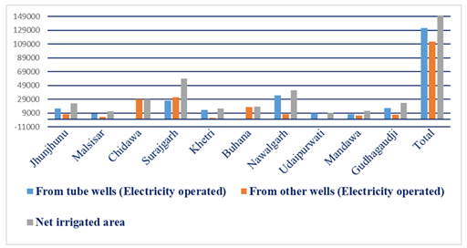
Figure 3 Electricity Operated (Wells and Tube Wells) Area in Jhunjhunu |
Figure 3 outlines the area of distribution in Jhunjhunu on both irrigated and non-irrigated pathways. The measured fig reflects an overall trend and cultivable area in Jhunjhunu district of Rajasthan, India.
The Table 3, which shows the distribution of Jhunjhunu's irrigation and non-irrigation methods by subdivision.
Table 3
|
Table 3 Distribution of Jhunjhunu's Irrigation and Non-Irrigation Methods by Subdivision |
||||||
|
S.
No |
Subdivision |
From Canals |
From
Ponds |
From
Tube wells |
From other wells |
Net
irrigated area |
|
1 |
Jhunjhunu |
0 |
0 |
17569 |
8185 |
25754 |
|
2 |
Malsisar |
0 |
0 |
5685 |
5840 |
11554 |
|
3 |
Chidawa |
0 |
0 |
54 |
34098 |
34152 |
|
4 |
Surajgarh |
0 |
0 |
34310 |
40559 |
74869 |
|
5 |
Khetri |
0 |
0 |
15982 |
2700 |
18682 |
|
6 |
Buhana |
0 |
0 |
624 |
19232 |
18856 |
|
7 |
Nawalgarh |
0 |
0 |
34540 |
8978 |
47518 |
|
8 |
Udaipurwati |
0 |
0 |
10298 |
876 |
11174 |
|
9 |
Mandawa |
0 |
0 |
7705 |
5576 |
13302 |
|
10 |
Gudhagaudji |
0 |
0 |
22251 |
8671 |
30922 |
|
11 |
Total |
0 |
0 |
153018 |
134736 |
287754 |
The agricultural development in the area has led to a significant improvement in the sector of agriculture in the past few years. Along with the significant changes in land use, new technology has led to an increase in productivity per hectare. Figure 4 shows distribution of tube wells (electricity operated) in the research area in subdivision.
Figure 4
|
Figure 4 Distribution of Tube Wells (Electricity Operated) in the Research Area in Subdivision |
8. Importance of research
The majority of people who work are employed in agriculture, which is an extremely demanding industry. The natural world is the foundation of agriculture. Because these factors vary widely across the globe, attempts are made to alter them so that their usefulness can be maximised and that natural resources can be used to their fullest by reducing obstructive conditions and advancing land use, crop production, and technology in accordance with local geographic conditions. Distribution in Jhunjhunu on both irrigated and non-irrigated pathways for crops Figure 2 and Distribution of tube wells (electricity operated) in the research area in subdivision in Jhunjhunu Figure 3 are reported, respectively.
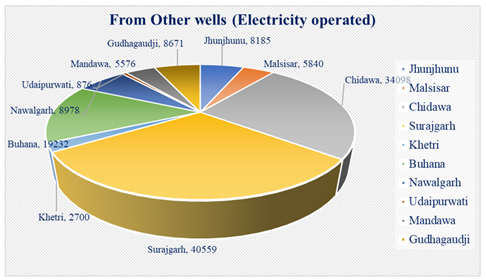
Nevertheless, productivity is low since population growth is occurring along with it. Because of low and erratic rainfall and a scarcity of groundwater, maximal production per unit area is an inadequate basis for meeting its needs. Because this kind of research hasn't been done in this field before. Distribution in Jhunjhunu, Distribution of tube wells (electricity operated) Figure 4 and Sub-divisional distribution of electricity operated wells in the research area Figure 5 are reported, respectively.
Therefore, it becomes crucial to undertake a study in order to determine the district's potential for agricultural development and regional imbalance. In order to raise the standard of living for the people living in the district, land productivity must be increased. Agricultural planners, administrators, and other relevant parties can then use this information to determine the best plan for the district's agricultural development schemes.
Figure 5
|
Figure 5 Sub-Divisional Distribution of Electricity Operated Wells in the Research Area |
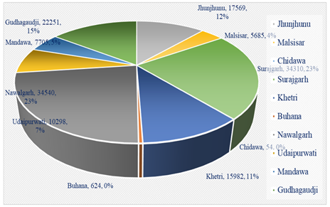
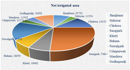
Regional disparities as spatial analysis about Jhunjhunu district of Rajasthan, India in Distribution of net irrigated area on study region has been reported Figure 6.
9. Research highlights
Studies suggest that the research goals of this study have been maintained in light of these.
1) To evaluate the district's tehsil-by-tehsil agricultural development and cropping pattern analysis.
2) To evaluate the district's analysis of the current cropping pattern and agricultural development.
3) To make recommendations for different plans aimed at fortifying the district's agriculture.
4) To list and recommend solutions for the social and economic barriers to agricultural development.
5) The current contribution of information and communication for advancement of agriculture.
6) The current contribution of agricultural credit programs to the development of agriculture.
7) Ideas for workable plan to elevate agriculture to the top industry in the state and the nation.
Agricultural geographers did not begin to systematically and scientifically research agricultural development under agricultural geography until after 1925. Research study describes certain significant investigations in this field.
Figure 6
|
Figure 6 Distribution of Net Irrigated Area on Study Region |
10. Discussion and conclusion
Agricultural activities are dependent upon geographical variances, the local arrangement of different agricultural elements, conditions inherent in agricultural activity patterns, and the farmer's level of social, economic, and technical development. Agricultural development, together with economic and technological factors, determines fluctuations in the production of agricultural crops in a given region. Farmers embrace new technology, mechanization, chemical fertilisers, improved seed types, pesticides, medications, and cutting-edge irrigation techniques as a result of agricultural progress, and this is ultimately reflected in increased productivity. Numerous changes have been brought about in the district's socio-economic sector by agricultural development. As a result, there is now more curiosity about the district's actual state of agricultural growth and regional imbalance. It becomes vital to research the regional imbalance of a certain place in order to assess the growing agricultural development, wealth, and social work in that area.
11. Future Scop of The Study
The current study has maintained its research objectives in light of this matter. Assess the research on cropping patterns and agricultural growth at the tehsil level in the Jhunjhunu district of Rajasthan, India. Evaluate the district's present agricultural development and cropping patterns study. Numerous plans have been put out to improve the district's agricultural industry's foundation. Determine the social and economic barriers to the development of agriculture and offer solutions. the current contribution of information and communication technologies to agricultural development.
12. Conclusion
The main objective of this study is to examine agricultural potential and advancements in the Jhunjhunu district of Rajasthan, India. The study has implications for agricultural planners, social workers, and development project administrators. To effectively build a plan for agricultural development and potential in the area under consideration, recommendations are intended. In light of these, the research objectives of the current study have been preserved. It is currently becoming more difficult to maintain traditional core business in India in a timely and balanced manner. Actually, the environment has an impact on the agriculture industry. But more pollution and human-caused damage have been recorded in Rajasthan, India's Jhunjhunu district than in any other industry.
In this approach, productivity per hectare can be increased multiple times and sustained at a high level provided high yielding crop types are cultivated with adequate soil management and the supply of critical nutrients to the plants. Because its issues should be taken into account by conducting deep and micro research, this research article will be more beneficial.
In this approach, productivity per hectare can be increased multiple times and sustained at a high level provided high yielding crop types are cultivated with adequate soil management and the supply of critical nutrients to the plants. Because its issues should be taken into account by conducting deep and micro research, this research article will be more beneficial.
Declaration of Competing Interest
The authors declare that they have no known competing financial interests or personal relationships that could have appeared to influence the work reported in this paper.
Data availability
All data has been incorporated in the manuscript and supplementary file.
Author contributions statement
Each and every part of this study project, including its conception, planning, data collection, analysis, interpretation, and revision, has been contributed to by authors Shyam S. Khinchi and Amit Kumar. Each author has participated in experiments, reviewed the article, interpreted data, checked the work for grammar and spelling, and designed the study. Furthermore, as a corresponding author, mentor, and supervisor of the study activity, the author Shyam S. Khinchi has contributed. The submitted version has the approval of all authors.
Declaration of generative AI and AI-assisted technologies in the writing process
The authors used GPT 4 to enhance the manuscript's language and readability when preparing it. The authors took full responsibility for the publication's content after utilizing this tool/service, reviewing and editing it as necessary.
CONFLICT OF INTERESTS
None.
ACKNOWLEDGMENTS
None.
REFERENCES
Amanor, K. S., & Pabi, O. (2007). Space, Time, Rhetoric and Agricultural Change in the Transition Zone of Ghana. Human Ecology, 35(1), 51–67. https://doi.org/10.1007/s10745-006-9081-6
Azadi, H., Ho, P., & Hasfiati, L. (2011). Agricultural Land Conversion Drivers : A Comparison Between Less Developed, Developing and Developed Countries. Land Degradation & Development, 22(6), 596–604. https://doi.org/10.1002/ldr.1037
Barlas, Y., Damianos, D., Dimara, E., Kasimis, C., & Skuras, D. (2001). Factors Influencing the Integration of Alternative Farm Enterprises into the Agro-Food System. Rural Sociology, 66(3), 342–358. https://doi.org/10.1111/j.1549-0831.2001.tb00071.x
Bilsborrow, R. E., & Okoth-Ogendo, H. W. O. (1992). Population-Driven Changes in Land use in Developing Countries. Ambio, 21(1), 37–45.
Damianos, D., & Skuras, D. (1996). Farm Business and the Development of Alternative Farm Enterprises: An Empirical Analysis in Greece. Journal of Rural Studies, 12(3), 273–283. https://doi.org/10.1016/0743-0167(96)00017-4
Feliciano, D. (2022). Factors Influencing the Adoption of Sustainable Agricultural Practices : The Case of Seven Horticultural Farms in the United Kingdom. Scottish Geographical Journal, 138(3–4), 291–320. https://doi.org/10.1080/14702541.2022.2151041
Khan, S., Yadav, S., Singh, V., & Khinchi, S. S. (2024). Land Use Change and Agro-Climatic Interactions. In P. Kumar & Aishwarya (Eds.), Technological Approaches for Climate Smart Agriculture (pp. 343–362). Springer. https://doi.org/10.1007/978-3-031-52708-1_17
Khinchi, S. S. (2018). Climate Change Effect on Biodiversity: A Review and Identification of Key Research Issues. International Journal of Current Engineering and Scientific Research, 5(5), 159–167. https://doi.org/10.21276/ijcesr
Khinchi, S. S. (2023). Impact of Agricultural Land use Changes on Economic and Social Development. Journal of Namibian Studies, 38(S1), 2334–2361. https://doi.org/10.3390/ijerph20054251
Khinchi, S. S. (Ed.). (2020). Issue in Agriculture and Environment. Ambica Book Agency. https://doi.org/10.2139/ssrn.5063911
Khinchi, S. S., & Kumar, A. (2024). Study on the Agricultural Landscape of Possible Opportunities and Imbalances for the Advancement of Agriculture in the Jhunjhunu District of Rajasthan, India. Indian Journal of Science and Technology, 17(47), 4966–4974. https://doi.org/10.17485/IJST/v17i47.3531
Khinchi, S. S., & Tanwar, M. (Eds.). (2015). Global Climate Change and Biodiversity. VL Media Solutions. https://doi.org/10.2139/ssrn.5028496
King, M. A. (1974). Economic Growth and Social Development: A Statistical Investigation. Review of Income and Wealth, 20(3), 251–272. https://doi.org/10.1111/j.1475-4991.1974.tb00922.x
Machiwal, D., Kar, A., Joshi, D. C., & Yadav, K. K. (2023). Land and Water Resource Management in the Thar Desert Region. In N. Varghese, S. S. Burark, & K. Varghese (Eds.), Natural Resource Management in the Thar dEsert Region of Rajasthan (pp. 77–102). Springer. https://doi.org/10.1007/978-3-031-34556-2_4
Meena, P., & Khinchi, S. S. (2023). Dynamic Trends in Land Utilization: A Case Study of Sawai Madhopur District, 2017–2022. Educational Administration : Theory and Practice, 29(3), 419–430. https://doi.org/10.53555/kuey.v29i3.5564
Varghese, N. (2023). Multidimensional Development in Thar Desert Region of Rajasthan. In N. Varghese, S. S. Burark, & K. Varghese (Eds.), Natural Resource Management in the Thar Desert Region of Rajasthan (pp. 293–312). Springer. https://doi.org/10.1007/978-3-031-34556-2_13
Verburg, P. H., Alexander, P., Evans, T., Magliocca, N. R., Malek, Z., Rounsevell, M. D., & Van Vliet, J. (2019). Beyond Land Cover Change : Towards a New Generation of Land use Models. Current Opinion in Environmental Sustainability, 38, 77–85. https://doi.org/10.1016/j.cosust.2019.05.002
Yadav, S., & Khinchi, S. S. (2024). Geospatial Mapping of Groundwater Potential Zones Using Multi-Criteria Decision Making AHP Approach in a Pisangan Watershed, Ajmer District (RAJ). In Disaster Management and Environmental Sustainability (pp. 243–261). John Wiley & Sons. https://doi.org/10.1002/9781394167463.ch20
 This work is licensed under a: Creative Commons Attribution 4.0 International License
© Granthaalayah 2014-2025. All Rights Reserved.