THE DIFFERENTIATION OF SETTLEMENTS IN THE MUNICIPALITY OF SREBRENICA AS A CONSEQUENCE OF AGGRESSION
Dr. Senada Nezirović 1![]()
![]()
1 Department
of Geography, University of Sarajevo, Faculty of Science, Zmaja od Bosne 33-35,
71 000 Sarajevo, Bosnia and Herzegovina
|
|
|
ABSTRACT |
|
|
The
municipality of Srebrenica is located in the
northeast of Bosnia and Herzegovina. Due to the aggression, in April 1992, a large number of residents left the area. Thus, the exile
crisis of the population of Srebrenica has begun and has not ended to this
day. The paper presents theoretical and practical research on the settlements
and population of Srebrenica and the changes that occurred after the
aggression and genocide. The paper identified the causes and problems faced
by the population living in this area today. Apart from literature and
planning documents, indicators obtained from municipal departments for social
activities, statistical indicators of the Agency for Statistics from the population
and household census were used in the preparation of the work. The results
show the demographic uncertainty, i.e. the municipality of Srebrenica is,
from a demographic point of view, one of the most affected areas by the war
in Bosnia and Herzegovina. |
|||
|
Received 30 June
2024 Accepted 02 August 2024 Published 15 September 2024 Corresponding Author Dr.
Senada Nezirović, nezirovicsenadapmf@gmail.com
DOI 10.29121/granthaalayah.v12.i8.2024.5690 Funding: This research
received no specific grant from any funding agency in the public, commercial,
or not-for-profit sectors. Copyright: © 2024 The
Author(s). This work is licensed under a Creative Commons
Attribution 4.0 International License. With the
license CC-BY, authors retain the copyright, allowing anyone to download,
reuse, re-print, modify, distribute, and/or copy their contribution. The work
must be properly attributed to its author.
|
|||
|
Keywords: Municipality of Srebrenica, Settlement
Differentiation, Population, Structural Changes |
|||
1. INTRODUCTION
1.1. Basic geographical indicators of the Study Area
The municipality of Srebrenica is
located in the northeastern part of Bosnia and Herzegovina, the region
in the Northeastern Bosnia that belongs to the northeastern part of Bosnia and
Herzegovina Nezirović (2018). The territory of the
municipality is located between 44° 7' north latitude and 19° 38' east
longitude. Basic Geological Map (1977). The northernmost point is located near
the settlement of Blječeva, at 44° 7' north latitude, and the southernmost
point is on the Drina river southwest of the Greben
corner at 43° 60' north latitude. The easternmost point is 19° and 38' east
longitude in the settlement of Petriča by the river Drina, the westernmost
point in the settlement of Žutica is 19° and 8' east longitude Basic Geological Map (1977).
The total
length of its borders is 153 km, of which 103 km are land borders and 50 km is along the Drina River Official
Gazette, (1981). The area within the stated borders
is 526.83 km2 or 1.03% of the total state territory Agency for statistics of Bosnia and Herzegovina (2016). The traffic orientation towards
Srebrenica has always been important, considering the connection from the
northeast to the southwest. The municipality has a favorable geographical
position towards the larger cities, Sarajevo and Belgrade, primarily due to the
distance of up to 200 km. It is connected with Bajina
Basta, Serbia, through traffic. The connection of Srebrenica to northern and
central BiH goes through the main roads M-4 Zvornik-Tuzla and M-19
Srebrenica-Vlasenica-Sarajevo Nezirović (2018).
The
origin and growth of the Srebrenica settlement were significantly influenced by
natural resources and road communications. Since ancient times, the settlement
of Srebrenica has been associated with a rich mine of lead and silver. It has
always been a symbol of silver exploitation and an important border point
towards Serbia, due to which medieval cities were built:
Donji i Gornji Srebrenik, Osatgrad, Đurđevac, Šubin, Ključevac
(Kličevac) i Vratar Kulenović
(1995). Many conquerors halted in this
area however, the greatest influence on its development has been left by Turks
and Austrians Jovanović
(1981). The studied municipal area
includes 81 cadastral municipalities with 410 settlements, which spatially and administratively
belong to 19 local communities Map of the Settlement of Srebrenica (1981). Settlements in the east, southeast, and south
of Srebrenica (Petriča, Crvica, Liješće, Skelani, Kalimanići,
Dobrak, Peći, Nogačevići, Rađenovići, Prohići,
Klotijevac) are located along the Drina River and gravitate towards the city of
Srebrenica and Bajina Bašta. In the northern area of Srebrenica
along the Križevica River are the settlements that gravitate to the town of
Srebrenica and the neighbouring municipality of Bratunac (Gostilj, Likari,
Pečišta, Potočari) Srebrenica
Municipality (2020). The Križevica river valley was an area of
intensive concentration of the population and provided the
possibility of more intensive employment in companies. In 1991, 15,715
inhabitants, or 42.8% of the total population of the municipality lived in the
22 valley settlements of Srebrenica Nezirović (2008).
The
settlements in the northwest of the municipality (Gornji Potočari,
Milačevići, Pale, Babuljice), and the northeast (Obadi, Sase,
Skenderovići, Dimnići, Brezovice), gravitate to Srebrenica and the
neighbouring municipality of Bratunac. The settlements in the southeast part
(Božići, Kostolomci, Žabokvica, Velika, Mala Daljegošta) gravitate to
Skelani and the neighbouring municipality of Bajina Basta. The largest number
of mountain settlements in the central-eastern and southern parts of the
municipality are located away from the main roads and are oriented along
uncategorized roads, which significantly affected their growth. The settlements
of the western area, Sućeska, and Podravanje gravitate to Srebrenica and
the neighbouring Municipalities of Milići and Vlasenica.
The
settlements of Luka and Krušev Do, which gravitate to Srebrenica, and the
neighboring municipalities of Višegrad and Rogatica are
located in the southwest. In 59 settlements in the mountain area of
Srebrenica in 1991, there were 20,951 inhabitants or 57.2%. The
most vital part of the municipality in terms of residents and population were
the settlements of local communities: Skelani, where 4,300 or 11.7% of the
population lived, Osatica 3,302 or 8.6%, and Potočari 4,402 or 11.9%.
5,756 or 15.7% of the population lived in Srebrenica. The population had
increased in the period from 1971 to 1991 by 7,428 or 7.9% Nezirović (2008).
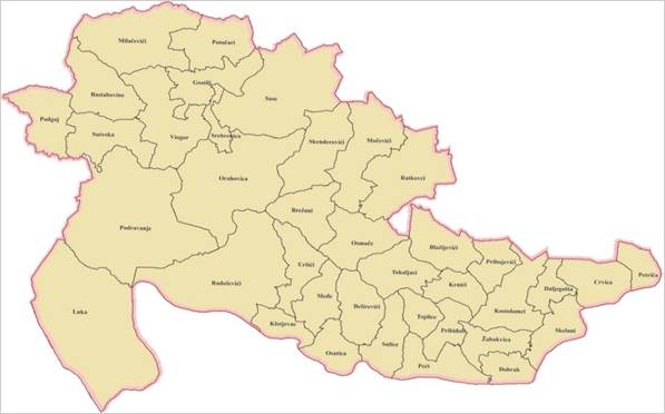
Figure 1
|
Figure 1 Populated
Places in the Municipality of Srebrenica According to Cadastral
Municipalities Source The Map Was
Made by the Author According to the Sources |
During
the 1980s, stronger economic growth of industry, mining, and spa tourism
started developing in Srebrenica, which caused more intensive employment of the
population and more increasing construction Archives of Srebrenica Companies (1981-1991). Thus, the surrounding settlements
of Potočari, Sase, and Skelani got a new modern form. In the settlement of
Sase, lead-zinc ore was exploited, which also contained significant admixtures
of silver and gold Ramović (1984). Intensive changes in the
development of the Srebrenica settlement caused daily migrations of the
employed population within the territory of Srebrenica, Potočara, Zelenog
Jadra, Sasa i Podravanja. These settlements had their gravitational areas, where
more daily migrants worked than permanent residents. The employed population
from Srebrenica migrated at a greater distance and with more difficult traffic
circumstances.
Table 1
|
Table 1 Daily Movement of Employees From their Place of Residence to their Place of Work In Srebrenica in 1991. |
|||
|
Distance |
daily traffic |
% |
Settlements of local
communities from which employees travelled |
|
up to 15 km |
2.279 |
73,2 |
Gostilj, Potočari, Sase,
Srebrenica,[1] Orahovica, Vijogor, Sućeska. |
|
up to 25 km |
269 |
8,6 |
Podravanje, Brežani,
Skenderovići, Toplica. |
|
up to 35 km |
206 |
6,7 |
Krnići, Ratkovići,
Radoševići, Osat. |
|
up to 45 km |
168 |
5,3 |
Skelani. |
|
up to 50 km |
190 |
6,2 |
Crvica, Kostolomci, Luka. |
|
Total |
3.112 |
100 |
|
|
Source Statistical Yearbooks of
Bosnia and Herzegovina, Republic Institute of Statistics, 1991, Sarajevo,
Archives of Srebrenica companies1981-1991. |
|||
The daily
trips of the employed population can be observed in two ways: outside the
settlement, it was not possible to provide accommodation for all workers and
permanent residents, and the other cause was the lack of funds. In this way, in
social terms, the so-called “pollutants” were established. This is a category
of farmers who have been forced to earn money outside the agriculture but are
partly tied to the house and property in their settlement. The development of
industrial zones, ore exploitation, strengthening the work function, initiated
the construction of roads and reinforced bus lines that transported 8,143
people a day, of which only 3,000 were primary and 1,105 secondary school
students Information
Service, Srebrenica Mayor's Office, (2019). Daily movements differ by
individual activities in which 5,290 employees or 68.9% of the total 7,670
employed workers participated in daily movements.
Table 2
|
Table 2 The Daily Commuting Flow of Employed Population According to Workplace in the Economic Sectors of Srebrenica, 1991. |
|||||||||||||
|
Local communities |
Population |
Employed |
Daily
employee traffic |
Agriculture,
fishing |
Forestry |
Industry, mining |
Construction industry |
Craft |
Traffic |
Tourism |
T rade |
Housing and communal activities |
Healthcare, education |
|
Brežani |
1.206 |
128 |
122 |
- |
23 |
12 |
59 |
2 |
2 |
1 |
5 |
- |
18 |
|
Crvica |
622 |
62 |
58 |
2 |
10 |
10 |
18 |
5 |
9 |
1 |
1 |
- |
2 |
|
Gostilj |
1.146 |
274 |
243 |
2 |
37 |
155 |
25 |
2 |
10 |
3 |
9 |
3 |
5 |
|
Kostolomci |
1.063 |
63 |
58 |
- |
11 |
5 |
32 |
5 |
1 |
1 |
2 |
- |
1 |
|
Krnići |
1.757 |
67 |
57 |
- |
7 |
8 |
12 |
4 |
- |
5 |
- |
- |
21 |
|
Luka |
1.011 |
79 |
74 |
- |
43 |
17 |
4 |
6 |
- |
- |
- |
- |
4 |
|
Orahovica |
1.119 |
165 |
156 |
- |
78 |
18 |
35 |
5 |
4 |
8 |
7 |
- |
1 |
|
Osat |
3.302 |
330 |
322 |
14 |
45 |
53 |
145 |
13 |
5 |
7 |
4 |
3 |
32 |
|
Podravanje |
780 |
177 |
158 |
- |
41 |
71 |
34 |
2 |
6 |
- |
1 |
- |
3 |
|
Potočari |
4.402 |
758 |
457 |
1 |
23 |
182 |
169 |
16 |
26 |
27 |
8 |
- |
5 |
|
Radoševići |
2.203 |
124 |
122 |
- |
35 |
26 |
38 |
2 |
1 |
3 |
2 |
1 |
- |
|
Ratkovići |
784 |
122 |
118 |
- |
44 |
29 |
25 |
11 |
1 |
1 |
- |
1 |
6 |
|
Sase |
1.131 |
802 |
337 |
- |
93 |
161 |
13 |
10 |
29 |
2 |
6 |
13 |
10 |
|
Skelani |
4.380 |
727 |
582 |
- |
63 |
110 |
201 |
53 |
35 |
48 |
35 |
5 |
32 |
|
Skenderovići |
1.516 |
243 |
238 |
- |
103 |
105 |
12 |
1 |
- |
1 |
12 |
1 |
3 |
|
Srebrenica |
5.746 |
2.953 |
1.600 |
3 |
140 |
457 |
150 |
86 |
287 |
131 |
185 |
28 |
133 |
|
Sućeska |
2.935 |
386 |
386 |
12 |
148 |
109 |
65 |
12 |
12 |
4 |
7 |
2 |
15 |
|
Toplica |
760 |
123 |
118 |
- |
51 |
14 |
33 |
4 |
6 |
5 |
3 |
1 |
1 |
|
Vijogor |
759 |
87 |
84 |
- |
21 |
31 |
8 |
2 |
7 |
10 |
3 |
1 |
1 |
|
ukupno |
36.666 |
7670 |
5.290 |
34 |
1016 |
1573 |
1088 |
241 |
441 |
258 |
290 |
59 |
290 |
|
% |
|
|
100 |
0,6 |
19,2 |
29,7 |
20,5 |
5,4 |
8,4 |
4,9 |
5,5 |
1,2 |
5,5 |
|
Source Statistical Yearbooks of Bosnia
and Herzegovina, Republic Institute of Statistics, 1991, Sarajevo, Archives
of Srebrenica companies1981-1991. |
|||||||||||||
Insufficient
and inadequate number of vacancies in residential settlements resulted in the
immigration of the population to places of work. The outflow of the population
ranged between 3,900 and 5,000 inhabitants (over ten years). The city centre of
Srebrenica was the most important focus of socio-economic changes in the
municipality. Due to the lack of space, the town expanded towards the north
along the river Križevica. Thus, a new settlement Vidikovac was built between
the main road leading to the northern industrial zone and the asphalt road to
the Sasa mine.
The newly
built settlement was created due to good road communication and favourable land
prices, which is why this area was favourable for the population from the
surrounding settlements. Business enterprises in Srebrenica developed and
became the main regulator of employment of the entire population in the
municipal area. The intensity of socio-economic changes in the settlements was
intensified so that Srebrenica in 1980 had a clearly defined socio-economic
urban area. It was a general tendency for the city to grow along with the
growth of its area and for the character of the urban area to change with the
addition of new settlements. This primarily referred to the development of
industry, construction, and the development of service industries Nezirović (2022).
The
backbone of economic growth during the last century was climatic potentials and
healing springs, which initiated the development of spa and medical tourism.
Thus, Srebrenica was known for the unique iron-arsenic Guber waters in the
vicinity of the city centre. With these changes, the southeast of
the city was focused on the development of tourism and the north
and northeast of the surrounding area on the development of
industry and mining. In this way, the value of the surroundings, especially
suburban settlements, has increased.
The
entire transformation of the city of Srebrenica is a
reflection of the interaction of attractive and expulsive factors. The
main attractive factors of the city centre are the function of work, i.e. the
number of jobs and employment in the city. Social circumstances, the economic
structure of the population, transport connections, and other characteristics
were the main expulsive factors. The urban population concerning the total
population in the period 1961-1991, increased to 5,746 inhabitants.
Intensive
construction in the 1970s influenced the physiognomy of the Srebrenica urban
area Official
Gazette, (1981). During that period, the
construction of the following began: a primary school, the city centre second
solitaire, a bus station, a health centre, an Argentaria station, a department
store, and several building blocks. The construction followed the course of the
Križevica River. Seven new residential buildings and several private houses
were built in the settlements of Baratova and Mlinište. This primarily refers
to the function of living. In that period, the largest residential settlement
Panađurište with seven apartment blocks and 195 apartments was built on an
area of 1,655 m2 Srebrenica
Municipality (2004). The families of employed workers have moved
into the newly built facilities according to the housing lists of priorities in
the Srebrenica companies. From 1981 to 1991, the urban area in its development
acquired the character of relative decentralization, housing construction
expanded towards Potočari. By 1991, 7,728 housing units had been built, of
which 6,781 or 87.8% were private houses and 947 or 12.2% were 64 residential
buildings. The urban area of 49,217 ha has 2,827 housing units as
private houses (2,116 or 74.9%) and 44 residential buildings with 711
apartments or 25.1% Urban
Planning Service, (1997).
The average population density
in the urban area of Srebrenica was 117 inhabitants/ha, which resulted in
overcrowding. The narrow Križevica river valley prevented the expansion of the
Srebrenica urban area, so the city's development was directed towards Potočari,
where the main economic enterprises of the municipality were. Reinforced bus
lines to the neighbouring settlements allowed the arrival of the population
from the surrounding area for one day and return to the place of permanent
residence. With the growth of daily migrations, the gravitational area of
Potočari, Skelani, and Sase was formed. These settlements
had more urban facilities and supporting infrastructure, so they had a lower
degree of urbanization. The other settlements of Srebrenica were rural.
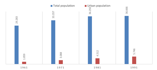
Figure 2
|
Figure 2 Graph Showing Urban
Population in Srebrenica 1961 – 1991. Source Statistical Yearbooks of
Bosnia and Herzegovina, Republic Institute of Statistics, 1991, Sarajevo,
Agency for Statistics of Bosnia and Herzegovina, 2016 |
On April
6, 1992, with the beginning of the siege of Sarajevo, the JNA and the Serbian paramilitary
units of the neighbouring state of Serbia and Montenegro (Federal Yugoslavia)
carried out aggression against sovereign Bosnia and Herzegovina, and from 1993,
Croatian HVO paramilitary units joined the aggression. Everything experienced
under fascist occupation was repeated between 1992 and 1995, on a much larger
and more horrific scale. The events of the war caused the displacement of the
population, both due to the war and ethnic differences. This marked the
beginning of the Srebrenica exile crisis. The population left the territory in
various ways in exile, forced displacement, and deportation. In this way,
Srebrenica was exposed to losses, both killings and evictions/emigrations.
2. Materials and Methods
The paper explains the causes and consequences of the existing state of settlements in the municipality of Srebrenica, after the aggression and the problems faced by the population of this area today. The studied municipal area includes 81 cadastral municipalities with 410 inhabited places, which spatially and administratively belong to 19 local communities: Brežani, Crvica, Gostilj, Kostolomci, Krnići, Luka, Orahovica, Osatica, Podravanje, Potočari,Radoševići, Ratkovići, Sase, Skelani, Srebrenica, Skenderovići, Sućeska, Toplica and Viogor. The valley of the Križevica River was an area with intense population concentration and it offered the possibility of more intensive employment in economic enterprises.As a result of the aggression in April 1992, a large number of residents left the area. This started the exile crisis of the population of Srebrenica. The events of the war caused displacement of the population, both because of the war and because of ethnic differences. During the aggression, there was the strongest migration of the population of this area. The methodology is primarily based on analysis and synthesis, induction and deduction, then on detailed field research of the municipality of Srebrenica. In the preparation of the paper, in addition to literature and planning documentation, indicators obtained from municipal departments for social activities were used, as well as statistical indicators of the Agency for Statistics from the population and household census.
3. Results and Discussions
The war
imposed on Bosnia and Herzegovina by the Serbian aggression significantly
changed the demographic picture of the municipality. The Serbian aggressor
captured the town of Srebrenica on July 11, 1995, and expelled the Bosniak and
Croat populations from Srebrenica. The town experienced terrible destruction
and great human suffering. Genocide was committed against the non-Serb
population by killing 8,372 people. It was the largest crime since World War II
in modern European history Documents
on the Srebrenica Crimes Committed in July (1995).
One of the basic elements of the genocide against the non-Serb
population was the forcible expulsion and killing of the Bosniak population
from certain territories that the aggressors considered to be their ethnic
territory. The war in Bosnia and Herzegovina ended with a peace agreement
initiated on November 21, 1995, in Dayton, Ohio, on December 14, 1995 formally signed in Paris. The Dayton Agreement
acknowledged Bosnia and Herzegovina as an independent and sovereign state in
the European Union of States Nezirović (2022). It was not until 2000 that
minority returns to settlements in the Srebrenica area began. The first wave
encountered 3,687 people having been returned to their pre-war settlements in
2004 Urban
Planning Service, (2020). The post-war period passed with
the gradual return of a part of the population, and it is characterized by a
relatively slow reconstruction of housing, roads, and ore-industrial complexes.
The
population is constantly declining, and the emigration of the population has
increased, which results in negative rates of natural change. The reduced
population is the most obvious problem. Settlements with a very small
population predominate. Most of them fall into the category of 1-100
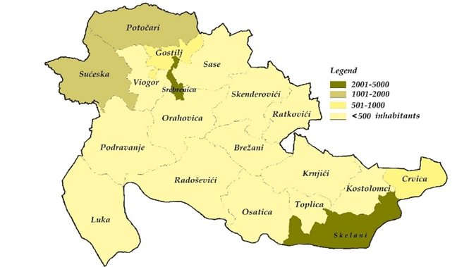
inhabitants (44) in which only 2,260 inhabitants live today. In the settlements
of 101-500 inhabitants (31) there are a total of 5,605 inhabitants. There are 5
settlements with 501-1000 inhabitants and 3,134 inhabitants. There is only one
settlement with more than 2000 inhabitants Urban
Planning Service, (2020) Table 3.
Table 3
|
Table 3 Classification of the Settlement of Srebrenica |
||||||
|
Size |
1971 |
1991 |
2013 |
|||
|
Number
of settlement |
Population |
Number
of settlement |
Population |
Number
of settlement |
Population |
|
|
5,001-10,000 |
0 |
1 |
5,746 |
0 |
- |
|
|
2,001-5,000 |
1 |
3,088 |
0 |
- |
1 |
2,410 |
|
1,001-2,000 |
1 |
1,410 |
2 |
2,270 |
0 |
0 |
|
501-1,000 |
16 |
10,541 |
18 |
11,358 |
5 |
3,134 |
|
101-500 |
61 |
18,251 |
56 |
17,093 |
31 |
5,605 |
|
1-100 |
1 |
67 |
3 |
199 |
44 |
2,260 |
|
Uninhabited |
0 |
- |
1 |
0 |
0 |
- |
|
Total |
80 |
33,357 |
81 |
36,666 |
81 |
13,409 |
|
Source according to Agency for Statistics of Bosnia and
Herzegovina 2016, Statistical Yearbooks of Bosnia and Herzegovina, Republic
Institute of Statistics, 1991, Sarajevo. |
||||||
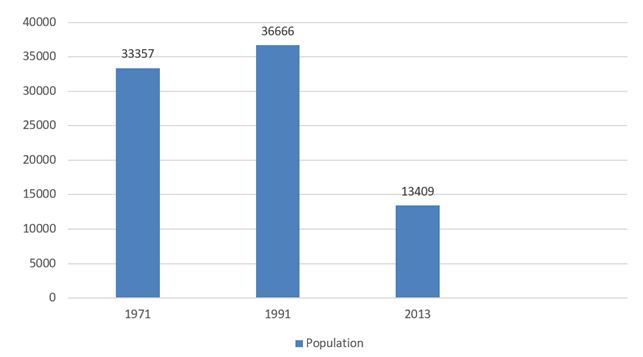
Figure 3
|
Figure 3 Graph of the Population
of Srebrenica in the Period 1971-2013 Source according to Agency for Statistics of Bosnia and Herzegovina 2016, Statistical Yearbooks of
Bosnia and Herzegovina, Republic Institute of Statistics, 1991, Sarajevo. |
The
aggression stopped the growth of the population and the development of the
settlements. According to most demographers, the municipality of Srebrenica had
the highest fertility among several municipalities in Bosnia and Herzegovina.
Due to the slow socio-economic development in the post-Dayton period, the
population rate decreased, which is a consequence of the decrease in
population. Today there are 13,409 inhabitants, which is 23,257 people or 61%
less than in 1991. The average population density is 14 people per km². All
settlements in 18 local communities had a population decline: Brežani -856,
Gostilj -400, Kostolomci -644, Krnići -1,318, Luka -658 Podravanje -545,
Potočari -2,568, Radoševići -1,617, Ratkovići -594, Sase -906, Skelani
-1,965, Srebrenica -3,336, Orahovica -794, Osatica -2,922, Skenderović
i-1,347, Sućeska -1,541, Toplica -824 i Viogor -641 Table 4.
Table 4
|
Table 4 Population Characteristics in the Settlements in 18 Local Communities 1991-2013 |
||||
|
Local
communities |
1991 |
2013 |
+/- |
|
|
1 |
Brežani |
1,224 |
368 |
-856 |
|
2 |
Crvica |
609 |
828 |
219 |
|
3 |
Gostilj |
1,197 |
797 |
-400 |
|
4 |
Kostolomci |
1,061 |
417 |
-644 |
|
5 |
Krnići |
1,674 |
356 |
-1.318 |
|
6 |
Luka |
1,007 |
349 |
-658 |
|
7 |
Podravno |
774 |
229 |
-545 |
|
8 |
Potočari |
4,373 |
1,805 |
-2.568 |
|
9 |
Radoševići |
1,967 |
350 |
-1.617 |
|
10 |
Ratkovići |
788 |
194 |
-594 |
|
11 |
Sase |
1,128 |
222 |
-906 |
|
12 |
Skelani |
4,283 |
2,318 |
-1.965 |
|
13 |
Skenderovići |
1,522 |
175 |
-1.347 |
|
14 |
Srebrenica |
5,746 |
2,410 |
-3.336 |
|
15 |
Orahovica |
1,112 |
318 |
-794 |
|
16 |
Osatica |
3,392 |
470 |
-2.922 |
|
17 |
Sućeska |
2,930 |
1,389 |
-1.541 |
|
18 |
Toplica |
1,120 |
296 |
-824 |
|
19 |
Viogor |
759 |
118 |
-641 |
|
Total |
36,666 |
13,409 |
-23,257 |
|
|
Source Agency for Statistics of Bosnia and Herzegovina,
2016. |
||||
Only in
two settlements in the local community Crvica had the population increase by
209 inhabitants and only 1 inhabitant returned to Palež. The return of the
population to Srebrenica should be the foundation of political, social,
demographic, economic, and national interests. The return not only removes the
tragic consequences of ethnic cleansing but also creates conditions for the
renewal and revival of the Srebrenica population, which have experienced the
most horrific genocide since World War II (Srebrenica
Potočari Foundation Memorial and Cemetery, Srebrenica). Due to the
war, the mass killing, expelling, and the forcible relocation of the
population, the spatial picture of the population changed, as shown in Fig. 2
and Fig. 3.
The
returnee population is the elderly population. The average number of households
has decreased to two members, with the age composition of the population being
less favourable, because the mortality of spouses rarefies them and transforms
them into singles. Negative changes have occurred in the age-sex structure of
the population, and are manifested by a lower share of
the younger population, and an increase in older age groups.
The cause
of this situation is the high war mortality rate of the population, which
results in an unfavourable age structure, i.e. the demographic uncertainty of
Srebrenica. Demographically, Srebrenica is one of the most war-affected areas
of Bosnia and Herzegovina. Unfortunately, living conditions in Srebrenica are
very poor and the support of the authorities is urgently needed.
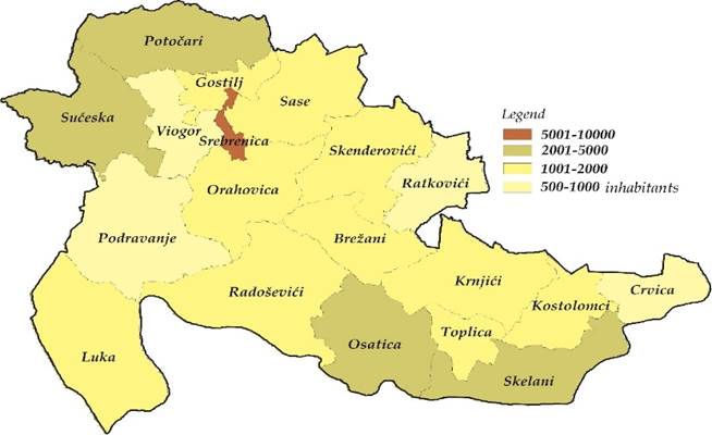
Figure 4
|
Figure 4 Inhabited Areas According
to Local Communities of the Municipality of Srebrenica in 1991 Source According to Institute for
Statistics of Federation of Bosnia and Herzegovina 1998 |
Figure 5
|
Figure 5 Inhabited Areas According to Local
Communities of the Municipality of Srebrenica in 2013 Source According to Agency for Statistics of Bosnia
and Herzegovina 2016 |
3.1. Businesses in Srebrenica after the war
The
dominant role in the economic structure in the pre-war period was played by
industrial production (The Statistical Yearbook, 1991). In 1991, 2,405 or 31.3%
worked in industrial enterprises and mines, and 1,240 or 16.1% in construction Archive
of Surveyed Business Enterprises of the Srebrenica Municipality, (2005). There were 1,119 workers in
forestry or 14.8% of the total number of employees Drina Forest Company, (2004). After the war, the reconstruction
of enterprises in Srebrenica had begun. Thus, by 2017, 936 companies were
restored. Bad economic conditions caused many businesses to close, so only 359
remained active. Information Service, Srebrenica Mayor's Office, (2019)
Table 5
|
Table 5 Employed Population of the Municipality of Srebrenica 1991-2006-2019 |
|||||
|
Company
name |
Activities |
Number
of employees |
|||
|
1 |
JSC
Lead and zinc mine "Sase" |
Production
of lead and zinc ore concentrate |
1524 |
357 |
497 |
|
2 |
JSC
Bauxite mine Srebrenica |
Mining
of bauxite ore |
169 |
41 |
43 |
|
3 |
JSC Feros |
Production
of brake systems |
250 |
Liquidation |
- |
|
5 |
JSC 11
Mart Srebrenica |
Refinement
of non-ferrous metals |
110 |
22 |
22 |
|
6 |
JSC
Veterinarska stanica |
Veterinary
services |
4 |
6 |
2 |
|
7 |
JSC
Zeleni Jadar |
Wood
processing |
703 |
4 |
- |
|
8 |
JSC
Guber Srebrenica |
Health
tourism and medical rehabilitation |
55 |
22 |
- |
|
9 |
JSC
Radnik Srebrenica |
Construction
activity |
736 |
- |
- |
|
10 |
JSC
Prevoz Srebrenica |
Transportation
of passengers and goods |
503 |
43 |
- |
|
11 |
JSC
Vezionica Srebrenica |
Production
of clothing |
200 |
- |
- |
|
12 |
JSC
Grad Srebrenica |
Tourism
and hospitality activities |
53 |
5 |
- |
|
13 |
JSC
Izbor Srebrenica |
Wholesale
and retail trade |
271 |
- |
- |
|
14 |
JSC
Limko Skelani |
Production
of tin packaging |
150 |
- |
- |
|
15 |
JSC
Napredak Skelani |
Wood
processing |
- |
5 |
- |
|
16 |
JSC As
Potočari |
Production
of accumulators and primary batteries |
575 |
Liquidation |
- |
|
17 |
Drina
Srebrenica |
Cultivation,
protection and exploitation of forests |
617 |
63 |
70 |
|
18 |
Polet Srebrenica |
Utilities |
109 |
30 |
63 |
|
19 |
Dom
kulture Srebrenica |
Culture,
education, information |
56 |
9 |
10 |
|
20 |
Auto-moto
company Srebrenica |
Repair
and servicing |
17 |
6 |
- |
|
21 |
LLC
Makljen Srebrenica |
Exploitation
and primary processing of wood |
- |
16 |
- |
|
22 |
LLC
Fabrika za pocinčavanje |
Metal
processing and coating |
230 |
45 |
100 |
|
23 |
LLC
Tehno Srebrenica |
Construction
activity and trade in building materials |
- |
24 |
- |
|
24 |
LLC
Stil Company Srebrenica |
Furniture
manufacturing |
- |
4 |
4 |
|
25 |
LLC
Svjetlost Srebrenica |
Trade |
- |
5 |
- |
|
26 |
LLC Z. Kojić |
Trade |
- |
5 |
5 |
|
27 |
LLC
Agapos Skelani |
Freight
transport (cutting and wood processing) |
- |
3 |
- |
|
28 |
LLC
Kaliman Srebrenica |
Furniture
manufacturing |
- |
4 |
- |
|
29 |
LLC
Cimos Srebrenica |
parts
for the automotive industry |
- |
61 |
90 |
|
30 |
LLC Boss
agro food Sarajevo |
Purchase,
processing and freezing of berries |
16 |
70 |
|
|
31 |
LLC
Tehnograd Srebrenica |
Construction,
transport and services |
- |
8 |
- |
|
32 |
LLC
Neimar Srebrenica |
Construction
activity |
- |
4 |
- |
|
33 |
LCC
Gusto esapore Srebrenica |
Cake
and ice cream production |
29 |
30 |
|
|
34 |
LLC
Osat |
Construction
activity |
5 |
5 |
|
|
35 |
LLC
Auto Moto Trade Srebrenica |
Technical
inspection of vehicles and catering activities |
18 |
- |
|
|
36 |
LLC
Bogol Srebrenica |
Wood
processing |
- |
2 |
- |
|
37 |
LLC
Feroles |
Joint
activity in forestry |
- |
12 |
- |
|
38 |
LLC
Pant trade |
Wholesale
and retail of paints and varnishes |
- |
2 |
- |
|
39 |
Public
Institution Pharmacy |
Drug
trafficking |
5 |
2 |
- |
|
40 |
Public
Institution Health Centre |
Primary
health care services |
156 |
44 |
50 |
|
41 |
Centre
for Social Work |
Social protection |
15 |
8 |
6 |
|
42 |
ZZ .
Srebrenica, Srebrenica |
Production
of planting material, land cultivation |
15 |
7 |
1 |
|
43 |
ZZ
Zadruga Srebrebica-Skelani |
Agricultural
activity |
- |
7 |
2 |
|
44 |
ZZ Osat |
Cultivation
and sale of fish |
- |
3 |
- |
|
45 |
JSC
Kamen Srebrenica |
Stone processing
and installation |
35 |
Liquidation |
- |
|
46 |
ZZ Potočari |
Mixed
farming |
- |
2 |
1 |
|
47 |
Youth
cooperative Crni Guber |
Mediation
in employment |
- |
3 |
- |
|
48 |
Privatni
poduzetnici |
SZR,
SUGR, STR |
483 |
655 |
|
|
49 |
LLC
Alma Ras |
Underwear
and sleepwear |
77 |
||
|
50 |
LLC
Klas |
Production
of products of rahatlokum |
10 |
||
|
51 |
EKO.M
pellet production |
Production
of pellets and briquettes |
- |
- |
25 |
|
52 |
“Ekonomik
Group” |
Production
of construction containers |
40 |
||
|
Total |
6.561 |
1.432 |
1.893 |
||
|
Source
tabular overview compiled by the author based on archival sources of economic
enterprises in the municipality of Srebrenica |
|||||
In addition to the mentioned shortcomings in the economic development of the municipality of Srebrenica, an additional problem is the outflow of the young population, especially in the last decade. The municipal authorities must work as soon as possible to create a favorable environment for the survival of the current young population, and strategically plan the launch of economic capacities and the attraction of the population to Srebrenica.Analysing the structure of settlements and the population of the municipality of Srebrenica, we can state that today the image of the pre-war Srebrenica has completely changed, both in terms of population and populated places. Even after twenty-seven years, the refugee crisis in Srebrenica is not over. The big question is whether the exiled citizens of Srebrenica will be able to return to their homes and whether they will stay and live in them after their return, or whether they will leave this area for economic and other reasons.
4. Conclusions
In Bosnia
and Herzegovina, the decline in birth and fertility rates will continue.
Decreasing birth rates and increasing mortality will result in high natural
population decline and a drastic reduction in the total population of Bosnia
and Herzegovina. The emigration of the working and fertile population, the
emptying of rural areas, and the departure to urban centres that will not be
able to meet expectations will continue. Due to accelerated aging, the current
average life expectancy could exceed the average of 50 years. This does not
mean that some trends in the demographic transition of society cannot be slowed
down and provide preconditions for a more positive and stable birth rate. All
this indicates the need for urgent mitigation and improvement of the situation
with appropriate and effective measures of population and social policy as part
of the overall development policy of the country. We should also insist on the
return of displaced persons and create preconditions for solving the housing
problem for young people, and before that provide employment.
The
natural potentials offered by Srebrenica are still unused. Therefore, the
cooperation of all entities in the municipality is necessary to accelerate the
program development of the economy. The construction of tourist facilities
would enable the further opening of this area and its natural resources
according to tourist flows and their valorisation in all forms of tourist
business. The basis for the post-war reconstruction and economic development of
Srebrenica is the launch of the production of non-ferrous and heavy metals,
sawn timber, plywood and hardboard, wood and tin packaging, and stone slabs. A
sustainable level of industrial production is possible through investment and
procurement of new equipment. It is necessary to provide wider sources of financial
resources for the reconstruction of about 300 km of roads. Special attention
should certainly be paid to the construction and maintenance of the local road
network, especially in the area of the
hydroaccumulation of Lake Peručac. Agriculture is one of the main
activities of the rural population, and at the same time, it is the main factor
in maintaining balance and environmental protection. Financial assistance and
education of agricultural producers are necessary to use natural resources and
reduce poverty in rural areas.
Livestock breeding, development of fisheries,
beekeeping, medicinal plants, and berries, can increase the use of natural
resources by increasing production and thus better market placement. The
efficiency of the business in the war and market problems are influenced by
numerous factors, which further complicate the privatization process, the
unresolved ownership structure of existing and the reconstruction of
Srebrenica's businesses. A positive example is certainly the economic -
cultural and sports event of Srebrenica, which has more and more participants
every year and acquires the character of an international event.
Srebrenica
with its natural resources, cultural wealth, and quality management, with the
help of municipal and regional government structures, can achieve economic
development. It is a big job for the municipal authorities and services, which
need to invest a lot of effort in order to attract
people willing to invest and rebuild the infrastructure and business
enterprises of Srebrenica. Despite all the financial resources that have flowed
into Srebrenica, economic development is still slow. Poor infrastructure, lack
of professional staff to work in Srebrenica, and insufficient conditions for
promoting Srebrenica as a place favourable for the development of economic
activities, are just some of the obstacles to successfully attracting foreign
and domestic investors.
CONFLICT OF INTERESTS
None.
ACKNOWLEDGMENTS
I would like to thank the Municipality of Srebrenica, for allowing me to see its documentation and contributing to the writing of this research paper, also, the Department for Economic Activity of the Municipality of Srebrenica, for accessing and using their documentation.
REFERENCES
Agency for statistics of Bosnia and
Herzegovina (2016). Census of Population,
Households and Dwellings in Bosnia and Herzegovina, 2013. Sarajevo.
Archive of Srebrenica
Municipality, (2017).
Archive of Surveyed Business
Enterprises of the Srebrenica Municipality, (2005).
Archives of Srebrenica
Companies (1981-1991).
Archives of Srebrenica
companies, (2020).
Basic Geological Map (1977). R: 1:100 000, List Ljubovija, Belgrade,
1-39.
Belgrade (1986). Basic Geological Map. R: 1: 100.000,Višegrad
Sheet, K- 34-3, Institute for Geology Ilidža and Geological Institute Belgrade
1970-1980.
Documents on the Srebrenica
Crimes Committed in July 1995, Institute for Research of Crimes Against
Humanity and International Law (1997).
Drina Forest Company, (2004). Srebrenica.
Information Service, Srebrenica
Mayor's Office, (2019).
Institute for statistics of
Federation of Bosnia and Herzegovina (1998), Census
of the Population, Households, Housing and Agricultural Holdings 1991.
Sarajevo.
Jovanović, Ž. (1981). Srebrenica kroz vijekove, Srebreničke novine br. 31. Srebrenica.
Kulenović, S. (1995). Etnologija sjeveroistične Bosne, knjiga II. Tuzla,183-256.
Map of the Settlement of Srebrenica
(1981). KO of the municipality of Srebrenica
Nezirović, S. (2008). Tourist Potentials of Srebrenica, Srebrenica Municipality.
Nezirović, S. (2018). Turistički Resursi Regije Sjeveroistočna Bosna:Univerzitetska
Naučna Monografija.
Nezirović, S. (2018). "Climatic Tourism Motives and their Role in Spatial Organization and Tourism Development of the
Northeastern Region of Bosnia". Internacional Journal of
Research-Granthaalayah India, 6(7), 52-64.
https://doi.org/10.29121/granthaalayah.v6.i7.2018.1283
Nezirović, S. (2022). Regionalna Geografija Bosne i Hercegovine II:
Univerzitetski Udžbenik.
Official Gazette, (1981). Spatial plan for the areas of Srebrenica. SO 4/81. Srebrenica.1-26
Ramović, M. (1984). Stari Rudnici, Sarajevo, 1-97.
Republic Institute of Statistics,
(1991). Statistical Yearbook of Bosnia and
Herzegovina.
Srebrenica Municipality
(2004). Property and Legal Affairs Office,
Srebrenica Municipality.
Srebrenica Municipality (2005).
Economic Development Plan of the Municipality.
Srebrenica
Municipality (2017). Development Strategies 2018-2022.
Srebrenica Municipality
(2020). Department of Economic Development,
Srebrenica.
Srebrenica Municipality
(2020). Geodetic and Property Legal Affairs.
Srebrenica Potočari
Foundation Memorial and Cemetery (2005).
Srebrenica.
Topographic Map 47, 4 - 3.
Srebrenica, (1976). Military - Geographical
Institute, Belgrade.
Urban Planning Service, (1997). Regulatory Plan of the City of Srebrenica, 4-10
Urban Planning Service, (2020). Srebrenica Municipality.
[1] In the urban
area of Srebrenica, 1,342 workers commuted daily to workplaces located within a
15 km radius
 This work is licensed under a: Creative Commons Attribution 4.0 International License
© Granthaalayah 2014-2024. All Rights Reserved.