Impact of High Radio Frequency Satellite Oscillations on Initiating Earthquakes
Md Rahimullah Miah 1, 4![]()
![]() , Md
Mehedi Hasan 2
, Md
Mehedi Hasan 2![]()
![]() , Jorin
Tasnim Parisha 3
, Jorin
Tasnim Parisha 3![]()
![]() ,
Alexander Kiew Sayok 4
,
Alexander Kiew Sayok 4![]()
![]() ,
Mohammad Belal Uddin 5
,
Mohammad Belal Uddin 5![]() , Shahriar Hussain Chowdhury 6
, Shahriar Hussain Chowdhury 6![]() , Md Main Uddin Miah 7
, Md Main Uddin Miah 7![]()
![]()
1 Head,
Department of IT in Health, North East Medical College and Hospital, Affiliated
to Sylhet Medical University, Sylhet, Bangladesh. and PhD Awardee from the
IBEC, UNIMAS, Sarawak, Malaysia
2 Department
of Law, Green University of Bangladesh, Dhaka, Bangladesh
3 Government Satis Chandra Girls’ High School, Sunamganj Sadar, Sunamganj, Bangladesh
4 IBEC, Universiti Malaysia Sarawak (UNIMAS), Kota Samarahan,
Sarawak, Malaysia
5 Department of Forestry and Environmental Science, Shahjalal University of Science and Technology, Sylhet, Bangladesh
6 Department of Dermatology & Venereology, North East Medical
College and Hospital, Affiliated to Sylhet Medical University, Sylhet,
Bangladesh
7 Faculty of Forestry
and Environment, Bangabandhu Sheikh Mujibur Rahman
Agricultural University, Gazipur, Bangladesh
|
|
|
ABSTRACT |
|
|
Advanced satellite
technology is worse than all the disasters on Earth due to the lack of
dynamic security. The study of earthquakes is the most innovative research of
all man-made disasters - no doubt, but there are new horizons of wonder for
the thoughtful. Earthquakes are increasing unexpectedly in different
countries of the world. People of most countries are worried about sudden
earthquakes, but no one is able to reveal the main secret of these
earthquakes. Many are blaming nature for this earthquake. Through this survey
the exact origin of the matter has been presented to the whole world with
proper evidence. Research shows that climate criminals are misusing advanced
satellite technology to cause these earthquakes. According to research,
misuse of advanced satellite technology causes artificial earthquakes at
specific GPS locations on Earth, resulting in severe damage to humans,
animals, plants and other objects. The intensity of these earthquakes is so
intense that everyone is surprised. Studies have shown that the misuse of
satellite technology has caused massive damage in man-made technological
earthquake at a particular tectonic plate and other disasters. Due to these
sudden earthquake, human suffering increases, standing institutions are
demolished, road communication systems are ruptured, crop lands and
residential areas are destroyed, individuals lose their lives. The study
revealed that artificial earthquakes are caused by sudden radio-waves and
strong oscillations of variable magnitude anywhere on earth. The study also
showed the climate criminals use various fake messages and wireless tracking
to influence policy-makers, the public and the media, as can be doubted in
this study, All citizens and administrations should
be aware and vigilant to prevent the rise of earthquake terror. The research
shows that using advanced satellite technology, earthquakes can be created in
time on any tectonic plate on the Earth. Moreover, the question remains that
when technology was not invented, but earthquakes occurred - which were
natural. Humans now generate artificial oscillations at specific GPS
locations through earthquake simulation coding by multiplying the magnetosphere
of previous natural earthquakes. The study shows that the EMMAST (Earthquake
Mitigation and Management through Advanced Satellite Technology) model will
make disaster mitigation systems safer and more efficient, saving millions of
lives. The study on earthquakes is unique with world- class scientific
research, which will open many research gateways for future generations. |
|||
|
Received 29 April 2023 Accepted 30 May 2023 Published 21 June 2023 Corresponding Author Dr. Md
Rahimullah Miah, drmrmiah@gmail.com DOI 10.29121/granthaalayah.v11.i5.2023.5142 Copyright: © 2023 The
Author(s). This work is licensed under a Creative Commons
Attribution 4.0 International License. With the
license CC-BY, authors retain the copyright, allowing anyone to download,
reuse, re-print, modify, distribute, and/or copy their contribution. The work
must be properly attributed to its author.
|
|||
|
Keywords: Advanced Satellite Technology, GPS
Location, Oscillation, Man-Made Earthquake |
|||
1. INTRODUCTION
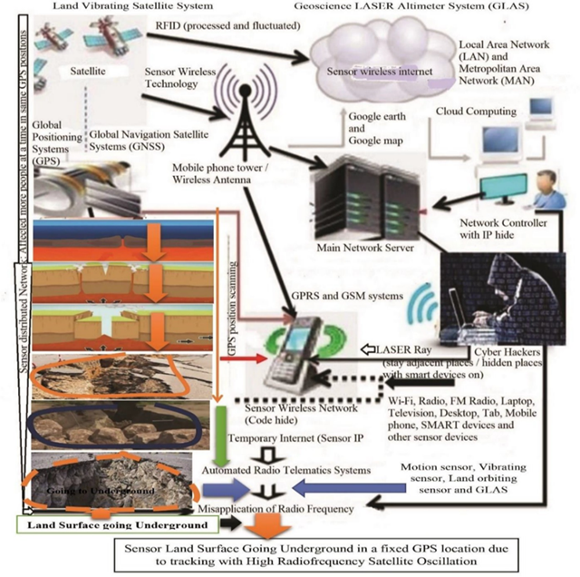
Earth is an ideal planet, habitable for all living things. Here all living beings live happily and rejoice. But suddenly the tremors of the earth spread sadness among everyone. Many people are surprised to ask the question - why is the world suddenly shaking today? What happened to this beautiful world? That's why nature or man is responsible? Miah et al. (2021h). Because people today are using advanced satellite technology, morning and evening are immersed in the ocean of this technology Al Jazeera (2021); Surampalli et al. (2021). But no one is fully aware of the misuse of this technology Miah et al. (2021f). Due to which, frequent earthquakes are happening in any selected place of the world, many lives and property are being lost, numerous bio-diversities are disappearing Miah et al. (2019); Miah et al. (2023i); Miah et al. (2022f); Miah et al. (2023d). So, because of the abuse of advanced technology, everyone in the world is afraid of earthquakes? Which will be known from this research. The sudden release of energy stored within the Earth to compress the rock to a selected GPS location causes the surface to momentarily shake, moving parts of the Earth's crust and striking an unknown phobia in life. This form of sudden unexpected and transient shaking is called earthquake. Earthquakes are caused by sudden radio-waves and strong oscillations of variable magnitude anywhere on earth. An earthquake is a sudden release of energy in the Earth's lithosphere that causes seismic waves through unexpected vibrations of the Earth's surface. The intensity of these earthquakes is so intense that everyone is surprised. They are so weak that they cannot be felt, violent enough to propel objects and people through the air, damage critical infrastructure, and wreak havoc across a fixed GPS location. Seismic activity in a given region due to high radio frequency tracking is the intensity, type and size of earthquakes experienced at a given time, which is a reminder for present and future generations. Earthquake is the average rate at which earthquake energy is released per unit volume at a given location on Earth. On Earth's surface, earthquakes manifest themselves by shaking and displacing or disrupting the ground. When the epicenter of a large earthquake is located offshore, the ocean floor can be displaced enough to cause a tsunami. Earthquakes can also cause landslides. In general terms, earthquakes are natural or man-made seismic events that are detected by advanced satellite technology— which generates seismic waves. Earthquakes are mostly caused by geological faults tracked with oscillating satellite technology. Cybercriminals misuse this advanced wireless technology to target volcanic activity, landslides, mine explosions and nuclear exploration Miah et al. (2021f). The primary rupture point of an earthquake is called the hypocenter or focus. The epicenter is the point at ground level directly above the hypocenter, imaged by advanced satellite technology.
The purpose of this research is to assess that earthquakes occur at specific GPS locations by exploiting advanced satellite technology.
2. Materials and Methods
The materials and methods included different study sites, multidata methodology, data sampling and oscillated design, global data collection, data compilation and data analysis for interpretation, which were followed by the methods listed below the uniform resource locators (URLs) in published papers.
1) Man-made Flash Flood:
https://doi.org/10.29121/granthaalayah.v11.i3.2023.5058
2) Man-made climate crisis:
http://article.sapub.org/10.5923.j.env.20211102.01.html
3) Digitally Killing Biodiversity:
http://article.sapub.org/10.5923.j.geo.20211101.02.html
4) Digital COVID-19 Disease:
https://ccsenet.org/journal/index.php/gjhs/article/view/0/46717
5) Digital Cardiac Disease- Cardiac Arrest:
http://article.sapub.org/10.5923.j.ijim.20221101.01.html
6) Digital ARDS:
http://article.sapub.org/10.5923.j.ajmms.20221206.05.html
7) Long term Digital Coronavirus:
https://un-pub.eu/ojs/index.php/wjer/article/view/5855
8) Digital Environmental Disease:
https://ccsenet.org/journal/index.php/jpl/article/view/0/47787
9) Digital Stomach Cancer:
http://article.sapub.org/10.5923.j.ajscr.20230501.02.html
10) Digital Loss of Biodiversity:
http://article.sapub.org/10.5923.j.ijbe.20220701.01.html
11) Discovery of Digital Coronavirus:
http://article.sapub.org/10.5923.j.scit.20211101.02.html
12) Man-made heatwaves:
http://article.sapub.org/10.5923.j.re.20221203.01.html
2.1. Study Site
UNIMAS stands for Universiti Malaysia Sarawak, a public university located in Kota Samarahan, Sarawak, Malaysia. Surrounded by green cover, the UNIMUS campus looks very attractive and beautiful, where the researcher's mind is always in deep concentration to research the niche area. The study was site mapped with tectonic coding. A campus lake at UNIMAS in Malaysia is the first test site in the niche area, where researchers applied ISNAPHO to study man-made earthquake risk factors, which as shown in Figure 1.
On the other hand, EMMAST was initially tested at the same location to ensure mitigation and management of artificial earthquakes. The study site was the adjacent lake of UNIMAS, Sarawak, Malaysia. A PhD research work was conducted at UNIMAS. The study was ISNAPHO (Impact of Sensor Networks towards Animals, Plants, Humans and Objects (Land Surface and Waterbody). UNIMAS in Sarawak is located in Borneo – the heart of the Malay Archipelago and an important dynamic campus for the scientific exploration of species. The UNIMAS educational ecosystem of world-renowned subject experts and scientists, innovative research - particularly environmental disasters, and state-of-the-art facilities are poised to mold tomorrow's leaders.
Figure 1
|
Figure 1 Study site on Map of UNIMAS, Sarawak, Malaysia |
2.2. ISNAPHO Design
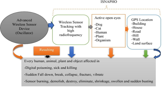
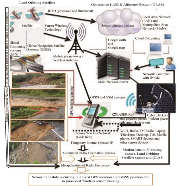
The study demonstrated the ISNAPHO design incorporates various research-related variables, which are outlined below: (i) area map coding study, (ii) Residential Area Mapping, (iii) coding of buildings or houses at a specific GPS location, (iv) Big tree coding for bench marks, (v) Human coding with retina scanning and fingerprinting, (vi) object coding with movable and immovable states, and (vii) Disease simulation coding in earthquake prone areas. The ISNAPHO experiment assesses the causes of human-caused earthquakes, flash floods, wildfires, landslides, tsunamis, cyclones, climate crises, including digital burn and sensor poison data in satellite tracking towards tectonic plate areas at a specific GPS location, as shown in Figure 2.
Figure 2
|
Figure 2 ISNAPHO Experiment (Miah et al., 2021f). |
2.3. Procedure of Man-made Earthquake
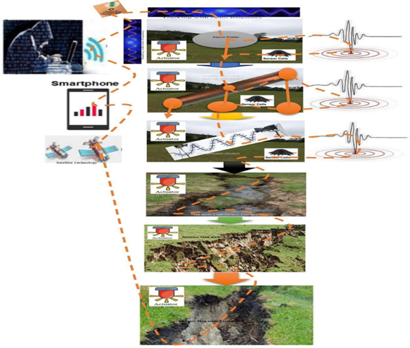
The study showed the procedures of man-made Earthquake, which as shown in Figure 3. The study also included Earthquake Simulation Code (ESC) of the particular tectonic plate for several times created artificial earthquakes with different magnitudes.
Figure 3
|
Figure 3 Procedure of Man-made Earthquake |
2.4. Tracking Procedures
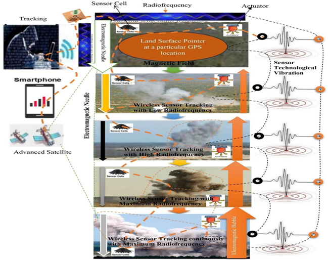
The study followed the ISNAPHO Experiment through wireless sensor tracking at a particular GPS location, which as shown in Figure 4. ISNAPHO implies Impact of Sensor Networks towards Animals, Plants, Human beings and Objects. The tracking procedures included in the following parameters, namely:
Wireless Sensor Tracking at a particular GPS Location======è Dog
Wireless Sensor Tracking at a particular GPS Location======è Cat
Wireless Sensor Tracking at a particular GPS Location======è Human
Human Wireless Sensor Tracking at a particular GPS Location======è Tree
Wireless Sensor Tracking at a particular GPS Location======è Land Surface
Wireless Sensor Tracking at a particular GPS Location======è Building or house
Wireless Sensor Tracking at a particular GPS Location======è Wall
Wireless Sensor Tracking at a particular GPS Location======è Bus
Wireless Sensor Tracking at a particular GPS Location======è Car
Wireless Sensor Tracking at a particular GPS Location======è Forest area or hill
Wireless Sensor Tracking at a particular GPS Location======è Water body (Lake/pond/river)
Figure 4
|
Figure 4 ISNAPHO Tracking Procedure |
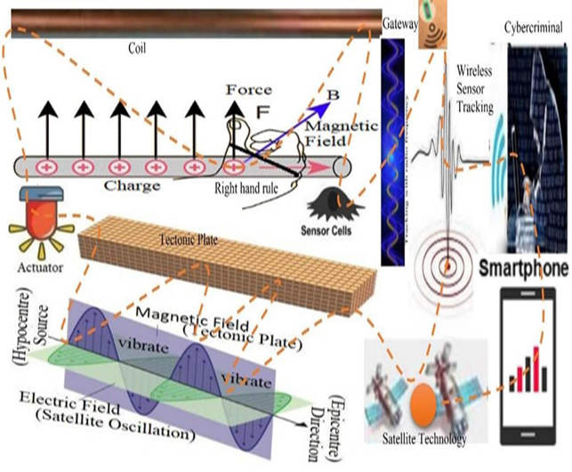
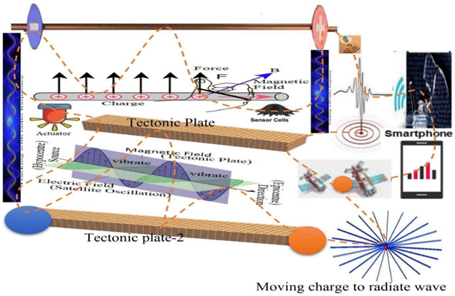
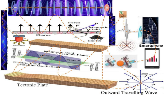
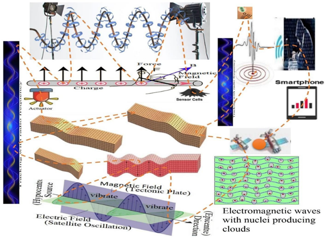
2.5. Application of Lorentz Methods
The study demonstrated the light waves are related to changing electric fields and magnetic fields Maxwell (1865), which reflects the Lorentz force. The application of the Lorentz method was demonstrated through satellite tracking of the magnetic field of a tectonic plate at a fixed GPS location at different oscillation stages Lorentz (1892); Heaviside (1889); Hirosige (1969); McCormmach (1970). When an object is tracked by a wireless sensor, electrons flow, because the conductor is made of non-magnetic copper. Electrons moving through the wire create a magnetic field at specific locations around the conductor, accompanied by a charged particle. As a result, more current flows through it in proportion to the magnetic field. Igneous rocks of tectonic plates contain magnetic minerals such as magnetite, whose grains are aligned with the Earth's magnetic field and become magnetized in that direction. Electrons moving through the wire create a magnetic field at specific locations around the conductor, accompanied by a charged particle. As a result, more vibration flows through it in proportion to the magnetic field. A tectonic zone is a type of magnetic field. Igneous rocks of tectonic plates contain magnetic minerals such as magnetite, whose grains are aligned with the Earth's magnetic field and become magnetized in that direction. Electrical impulses in tectonic plates direct a chain of single domain magnetic crystals that form an electromagnetic compass needle. The electromagnetic compass needle and magnetic field continue to generate vibrations while tracking selected tectonic plates. Electromagnetic compass needle connected coil secondary receptor. The electromagnetic compass needle always tries to rotate in alignment with the Earth's magnetic field, which acts at a 90° degree angle to its magnitude as it travels around the tectonic plates. Thus, weight or mass is not a factor in man-made earthquakes.
We have the Lorentz force,
Fm = qvB Sinθ, where θ is equal to 90 degrees between the velocity and the magnetic field. Or, Fm = qvB Sin90°
Or, Fm = qvB, [as Sin90°= 1], or, [Fm = qvB Sin0° = qvB x 0 = 0, as the charge is stopped]. Or, Fm = qvB x 1
Where, F = Lorentz force, q = charge, v = velocity, B = homogeneous magnetic field. So, Fm = qvB………………………………………. (1) Lorentz (1892).
Since the magnetic force is always perpendicular to the magnetic field (tectonic plate) with the component of the charge's velocity, it cannot change its motion. The force is maximum when the charge moves perpendicular to the tectonic plate (θ = 90°). Then the tectonic plates continue to vibrate. The force is zero if the velocity of the charge is in the same direction as the tectonic plate (θ = 0°). Thus, oscillations in selected tectonic plates have stopped.
Electric impulses or vibrations flying at a 90° angle to a uniform magnetic field, then researchers use mathematical formulas. For this reason, research has shown that the Lorentz force always acts at an angle of 90° to the direction of velocity. If the study doubles the strength of the magnetic field, the Lorentz force will also double. The electric field effect of an electromagnetic wave is tracked away from the epicenter and hypocenter (nucleus) by sensor cells (electrons) that vibrate an active cloud, which were shown in different steps (step 1 to 7).
Step-1: Coil Selection and setting-up at a particular GPS location to compare with tectonic plates in Figure 5.
Figure 5
|
Figure 5 Wireless Sensor Tracking Towards Coil to Compare with Tectonic Plate. |
Step-2: Coil setting-up charge direction at a particular GPS location to select the epicenter and hypocenter at tectonic plate in Figure 6.
Figure 6
|
Figure 6 Magnetic Field Oscillating Tectonic Plates Determined by Wireless Sensor Tracking Applied to the Lorentz Force (Moving Charge to Radiate Waves). |
Step-3: Coil wind at a particular GPS location with electric impulse to compare with tectonic plates in Figure 7.
Figure 7
|
Figure 7 Magnetic Field Oscillating Tectonic Plates Determined by Wireless Sensor Tracking Applied to the Lorentz Force (Moving Charge to Radiate Outward Travelling Waves). |
Step-4: Coil vibrates speedy at a particular GPS location with electric impulse in Figure 8.
Figure 8

|
Figure 8 Magnetic Fields Oscillating Tectonic Plates Determined by Wireless Sensor Tracking Applied to the Lorentz Force (The Electron Clouds Around the Nuclei are Symmetric and at Rest). |
Step-5: Coil vibrates high speedy at a particular GPS location with electric impulse in Figure 9.
Figure 9
|
Figure 9 Magnetic fields oscillating tectonic plates determined by wireless sensor tracking applied to the Lorentz force (the electromagnetic wave pushes the electron away from the nuclei producing clouds that are offset). |
Step-6: Coil observed changes ground direction with high speedy at a particular GPS location with electric impulse in Figure 10.
Figure 10
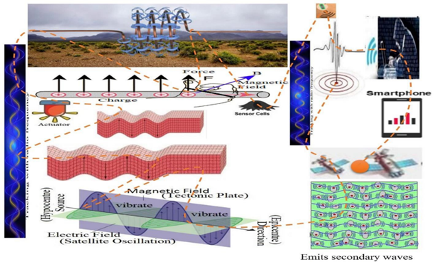
|
Figure 10 Magnetic Fields Oscillating Tectonic Plates Determined by Wireless Sensor Tracking Applied to the Lorentz Force (The Motion of the Charges Emits Secondary Waves that Interfere with the Applied Wave to Produce an Overall Slowing Effect on the Wave). |
Step-7: Coil vibrates at a particular GPS location with electric impulse to compare with tectonic plates in Figure 11.
Figure 11
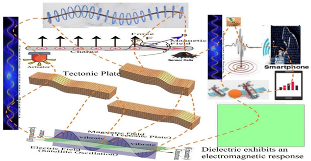
|
Figure 11 Magnetic Fields Oscillating Tectonic Plates Determined by Wireless Sensor Tracking Applied to the Lorentz Force for Stopping Vibration (A Dielectric Exhibits an Electromagnetic Response). |
2.6. Research Questionnaire
Research on man-made earthquakes and their effect on a particular tectonic plate surveyed respondents with a set of questionnaires. The questionnaire included respondent's name, age, gender, educational status, occupation, perception of man-made earthquakes, risk factors and impacts of earthquakes, EMMAST concepts, mitigation and management measures. Out of 100 respondents 55% are male and 45% are female. The respondents are all educated and students and teachers of educational institutions. Respondents' comments are detailed in the Results and Discussion section. Man-made disasters related cybercrime data were collected from different countries and scoring with pertinent parameters, namely (i) Minor cybercrime (ranking 0-20), (ii) Normal Cybercrime (21-40), (iii) Serious cybercrime (41-60), (iv) Major cybercrime (61-80), (v) Severe cybercrime (81-100). The score followed the parameters on man-made earthquake, climate crises, flash flood, landslide, tsunami, volcanic eruption, wildfire, heatwaves, extreme cold, building collapse, deforestation, desertification, digital burning, extrajudicial killing, digital killing, digital stealing, pandemics, bridge collapse, road fracture and land surface sensor blast. Each parameter valued 1- 5 ranking.
2.7. Data Analysis and Interpretation
Data are usually used in this study from single, multiple or different sources. Free earthquake data collected from various government and non-governmental organizations around the world. Qualitative and quantitative seismic events data related to man-made earthquake, flash flood, climate change, heatwaves, health care services were collected through field survey, laboratory tests, observations, interviews and informal communication with relevant stakeholders, while secondary data was obtained from diverse sources. Misuse of satellite technology makes risk assessment extremely challenging without considering important criteria and indicators that vary across studies on the location of tectonic plates. Data were compiled and analyzed for presentation and interpretation of results using standard data analysis software – MS Office Suite 2022, SPSS version 29 and R version 4.3.1 for Windows.
3. Results
3.1. Characteristics of Man-made Oscillated Earthquake
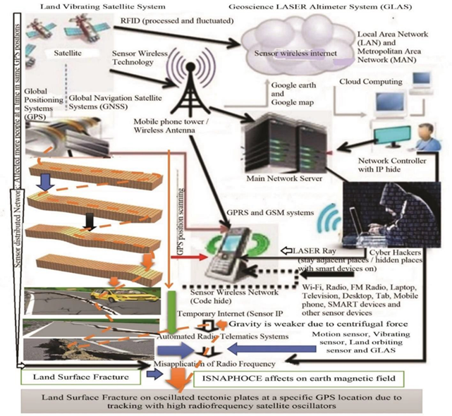
Studies have shown various effects of man-made onset earthquake including object oscillation, volcanic eruption, surface object demolition at specific GPS locations due to misuse of oscillated high radiofrequency satellite device. The study included different characteristics of onset earthquake, such as:
1) Surface object and living-beings suddenly oscillated,
2) Land surface fracturing,
3) Land edging rupture,
4) Man-made flash flooding,
5) Oscillated the particular GPS location,
6) Sensor landslides instantly,
7) Earthquake area digital poisoning,
8) Sensor electric loadshedding and barrier communication,
9) Sudden falling down and demolished of all tracking buildings and settlement,
10) Objects on the ground suddenly fall down and immediately collapsed
11) Invisible digital terrorist at a particular GPS location,
12) Sensor Thunder Storm, cyclone, tornedo at particular GPS location, and
13) Digital killing at the selected GPS area, etc.
The study showed that wireless sensor tracking towards trees and buildings affected in every sphere at the atmospheric environment, which as shown in Figure 12.
Wireless Sensor Tracking towards Tree and Building: (a) Leaf flashing and digital burning were occurred from standing tree due to wireless sensor tracking, (b) Buildings were falling, inclined, demolished, cracked, fractured and digital burning due to wireless sensor tracking with diverse radiofrequencies. Depending range of radiofrequency tracking, the building happened in unexpected giant crack, middle crack and small crack.
Figure 12
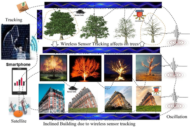
|
Figure 12 Tracking Towards Tree and Building with Advanced Wireless Sensor Technology |
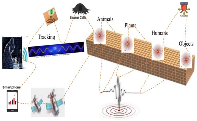
Studies have identified several effects due to tracking on plants, animals, people and objects, as shown in Figure 13. Every person, animal, plant and object can be eliminated, burned, poisoned, collapsed, destroyed, broken, obstructed, blocked, fractured and vibrated by wireless sensor tracking. Studies also show that sudden illness can lead to the death of survivors due to tracking to living beings. It is worth noting that wireless sensors are so dangerous through tracking, which poses a serious risk to everyone.
Figure 13
|
Figure 13 Impact of ISNAPHO |
3.2. Land Surface Collapsed
Figure 14
|
Figure 14 Land Surface Collapsed Due to Tracking with Advanced Satellite Technology. |
Research has shown that tracking with advanced wireless sensor technology at a specific GPS location result in sudden cracks in the ground surface, as shown in Figure 14. The study shows the application of the Lorentz force connecting ISNAPHO to the Earth's surface. Research has shown that tracking with ISNAPHO can cause any land surface to suddenly erupt violently. As tracking increases in the radio frequency range, the ground surface will crack instantaneously at greater depths. Moreover, due to tracking, the electromagnetic needle inoculates below the ground surface at a certain depth, so that active sensor cells, actuators and gateways can detect cracks distributed in different parts of the surface, causing a crisis in the climate. Cybercriminals create artificial earthquakes by tracking these tectonic plates to particular GPS locations.
3.3. Man-made earthquake areas
The study showed that Man-made earthquakes are controlled by cybercriminals in a specific simulation coding area. Due to their increasing magnitude, they have destroyed a lot of resources in earthquake prone areas. Research shows that modern residential areas are more affected by artificial earthquakes Table 1, such as selected areas or tectonic plates of cybercriminals, where they create artificial earthquakes by tracking satellites. Research shows that cybercriminals commonly track satellites to cause earthquakes in the following top ten areas including earthquake areas, code and its impacts. The study reveals that earthquake terrorists use the earthquake codes for vibrated several times with varied magnitudes in the same tectonic areas.
Table 1
|
Table 1 Top-Ten Tectonic Areas To Occur Man-Made Earthquake |
||||
|
Ranks |
Top-ten Areas occurred earthquakes |
Code |
Purpose |
Impact |
|
Top-ten |
Modern residential areas |
Mra0000 |
Retracking for vibration with diverse magnitude in the plate |
Severe |
|
Top-nine |
Large industrial areas |
Lia0000 |
Severe |
|
|
Top-eight |
Areas dominated by religious groups |
Rga0000 |
Severe |
|
|
Top-seven |
Historic areas and
multiple institutions |
Hia0000 |
Severe |
|
|
Top-six |
Production and processing areas |
Ppa0000 |
Major |
|
|
Top-five |
Social and cultural densely populated areas |
Dpa0000 |
Major |
|
|
Top-four |
Export and Import
Trade Zones |
Eiz0000 |
Major |
|
|
Top-three |
National and geo-political regions |
Ngr0000 |
Major |
|
|
Top-two |
Coordinated Economic Zones |
Cez0000 |
As usual |
|
|
Top-one |
Multipurpose contact and hygiene areas |
Mha0000 |
Minor |
|
3.4. Land Surface Sensor Blasting
The study shows the ISNAPHO experiment on land surface sensor blasting at a particular GPS location, which as shown in Figure 15. The study shows that cybercriminals use satellite tracking to suddenly detonate digital sensors at specific GPS locations on the land surface along the border of two countries. As a result, panic has spread between the two countries, policy makers spread different opinions in the media, but no one knows - what is the real secret of sudden digital blasting? High-ranking officials of the two countries continue to accuse and threaten each other. During this time, cybercriminals are sending bouncing messages, fake voice calls and video calls to social media and policy makers to create tension between the two countries. But due to lack of knowledge of advanced sensor technology among policy makers no one is able to verify its authenticity. In this tense environment, cybercriminals generate fake voice calls of Presidents/Prime Ministers of two countries with the help of artificial intelligence and the said voice calls are forwarded by cybercriminals to army chiefs and without verifying the authenticity of the voice calls, the army chiefs implement the forwarded voice calls. Thus, cybercriminals continuously misuse advanced satellite technology towards two more countries. As a result, communication and trade between the two countries was prohibited and at one point war broke out between them. Such wars cost enormous resources, cost millions of lives, and put the entire world into turmoil. During such disasters, cybercriminals increasingly misuse wireless sensor technology to conduct digital plots and subsequently create new pandemics and artificial earthquakes.
Figure 15
|
Figure 15 Land Surface Blasting due to Tracking with Advanced Satellite Technology at a Particular GPS Location. |
Furthermore, cybercriminals detonate wireless sensors on the banks of rivers or seas to break dams, causing flash floods and other disasters in the area. Similarly, sensor blasting on a large bridge led to a sudden loss of communication and blaming each other, eventually leading to conflict and war. Again, cybercriminals detonated sensors on crowds at political rallies and national special events in specific areas, resulting in many deaths and political crises. Finally, due to the lack of secure wireless sensor technology, cybercriminals are committing these crimes worldwide. The study pointed out that speedy prosecution of cybercriminals along with proper enforcement of laws by higher authorities is imperative for use of secure wireless sensor technology for all. The study also revealed that sudden sensor explosions due to wireless sensor tracking are often mistaken for bomb blasts. But their assumption is wrong, because bomb blast and sensor blasting are not the same, there are differences in waveform and GPS location between the two. Moreover, where sensor blasting has occurred, they are remote or border areas, and human access is time- consuming, but satellite networks are adequate.
3.5. Man-made Earthquake Procedure
Figure 16
|
Figure 16 Man-Made Earthquake Procedure with ISNAPHO Experiment |
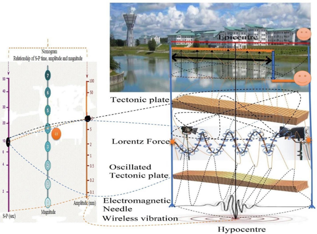
The study showed that the Man-made earthquake procedure was set-up adjacent the Lake of UNIMAS, Sarawak, Malaysia on January 21, 2017 at 2:00 am to 3:00 am. The experiment was ISNAPHO towards the UNIMAS Lake Plate, which as shown in Figure 16. The study observed the oscillation status within the time period of 10 seconds (2:30:50 am to 2:31:00 am) with light MMI Scale after switched on high radiofrequency device. The study was risk in tectonic location at UNIMAS and was confidential to avoid the misuse at the public place. The study was found the UNIMAS plate was vibrated due to wireless tracking in normal radiofrequency range at a particular GPS location. The location followed as the Rift-River (Lake)- Rupture. Two waves applied in this study. The tracking P-wave travelled quickly as pulse of energy through the tectonic plate. The primary wave was forced the ground to move backwards and forwards as it was compressed and expanded. The secondary wave (S-wave) followed the UNIMAS plate more slowly with a swaying rolling motion that shakes the ground back and forth perpendicular to the direction of the wave. There was an eerie sound and noise, which caused the object to change its GPS position. The study shows the relationship of S-P time (10 sec), amplitude (10mm) and magnitude (4.0 scale) at Nomogram. The study recorded only 4.0 magnitude scale due to confidential findings and unique research at UNIMAS, Malaysia.
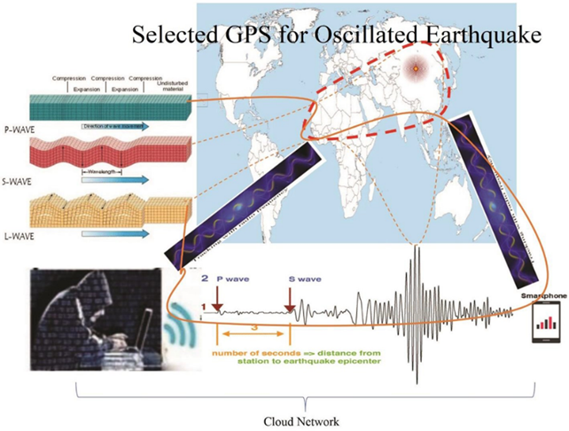
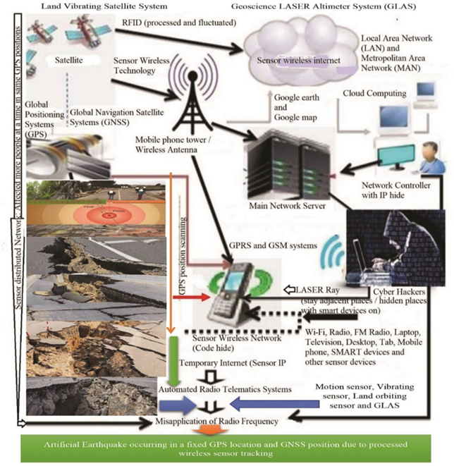
3.6. Selection of Particular GPS Map
The study illustrated the particular map selection in the selected GPS location for oscillated man-made technological earthquake, which as shown in Figure 17. The study showed the artificial earthquake map to oscillate through tracking with advanced satellite technology.
Figure 17
|
Figure 17 GPS Map Selection for creating Oscillated Technological Earthquake |
3.7. How to create Technological Earthquake?
The study shows the technological earthquakes at a particular tectonic plate, which as shown in Figure 18. Tectonic plates are selected along the Earth's length-width to create technological earthquakes. First, the study identified a selected point at a GPS location along a specific tectonic plate at a convergent boundary or divergent boundary. An epicenter was placed at a specific point on this 200 km long tectonic plate with a magnetic sensor field. An electromagnetic needle is inoculated with sensor cells at the transform boundary up to 10 m deep from the epicenter. A hypocenter was setup at the tip of the electromagnetic needle. Then the epicenter and hypocenter collide together as a vibrating beam of tectonic plate particles due to satellite tracking. The transition beam particle was constantly oscillating due to re-tracking with advanced satellite devices. The active cloud network continuously vibrates the beam particles at 90-degree angles across the tectonic plates. Thus, the mass or weight of the tectonic plates does not matter during the vibrations generated, but created fault. These vibrations are converted into earthquakes on certain fault of tectonic plates, whose magnitude is measured on the Richter scale. In this way, man-made earthquakes of various magnitudes can be created through the vibration of different tectonic plates of the earth by tracking with the help of satellite technology.
Figure 18
|
Figure 18 Distributed Man-Made Technological Earthquake with Tectonic Activities |
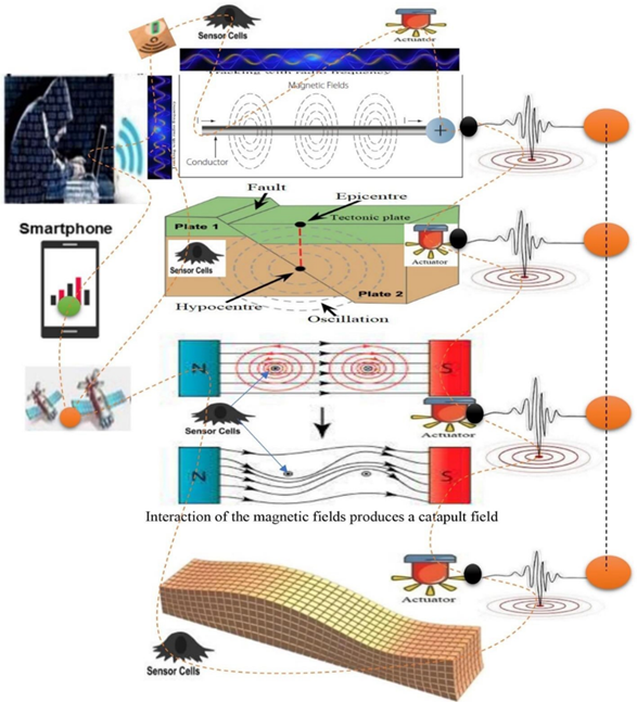
3.8. Interaction of Tectonic Plate
The study showed that oscillated technological earthquakes are caused by advanced satellite tracking processed at a particular GPS location, which as shown in Figure 19. The epicenters pointed at the border of the earth surface due to tracking the magnetic needle at lower portion of selective electromagnetic field. Before the high radiofrequency triggered the artificial earthquake, there was a sudden horrible sound and noise and the objects moved quickly. Due to the misuse of innovative advanced satellite technology, the results reflect on the sensed oscillation with stipulated timeframe magnitude. The study depicts artificial earthquakes, which occur on the land surface, riparian zones and other residential areas, through a sophisticated wireless cloud network system.
Figure 19
|
Figure 19 Interaction of Tectonic Plate (Magnetic Field) Generates Vibration at a Particular GPS Location (Oscillated Field) |
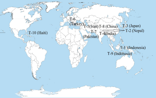
3.9. Top-ten deadliest in earthquakes
The study shows the top-ten deadliest in man-made earthquakes across the earth from 2001 to 2023 (till February), which as shown in Table 2. The highest dead in earthquake was 316000 in Haiti on 2010, where lowest dead 4340 in Indonesia on 2018. The ranks of top-ten countries showed in the map in Figure 20. The study illustrates the trend that recent major earthquakes between 2003 and 2023 have affected large populations in Haiti, Indonesia, China and Pakistan. The study also depicts significant changes in outcomes such as digital attacks, property damage, morbidity and mortality.
Table 2
|
Table 2 Top-Ten Deadliest in Earthquakes Across the Globe
from 2001 to 2023. |
||||
|
Top-ten ranks |
Country |
Year |
Deadliest |
Effect |
|
Top-ten |
Haiti |
2010 |
316000 |
Massive |
|
Top-nine |
Indonesia |
2004 |
227898 |
Massive |
|
Top-eight |
China |
2008 |
87587 |
Massive |
|
Top-seven |
Pakistan |
2005 |
87351 |
Massive |
|
Top-six |
Turkey-Syria |
2023 |
59259 |
Major |
|
Top-five |
Iran |
2003 |
34000 |
Major |
|
Top-four |
India |
2001 |
20085 |
Major |
|
Top-three |
Japan |
2011 |
19759 |
Major |
|
Top-two |
Nepal |
2015 |
8964 |
Major |
|
Top-one |
Indonesia |
2018 |
4340 |
Minor |
Figure 20
|
Figure 20 Top-Ten Severe Deadliest in Earthquakes Around the World |
3.10. Severe Top-ten Earthquake Magnitudes
The study shows the severe top-ten earthquake magnitudes across the globe from 2001 to 2023 (till June), which as shown in Figure 21. The highest severe magnitude was 9.1 in Indonesia in 2004 and less severe magnitude 6.6 in Iran in 2003.
Figure 21
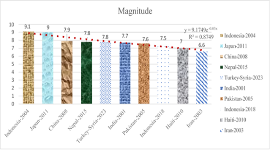
|
Figure 21 Top-Ten Earthquake Magnitudes |
3.11. Man-made disasters
The study shows that all the disasters happening in the world today are man-made technological disasters. These are earthquakes, tsunamis, heat waves, volcanoes, wildfires, flash floods, cyclones, tornadoes, extreme cold, landslides, droughts and desertification, which as shown in Figure 22. An earthquake is a sudden release of energy in the Earth's lithosphere that causes seismic waves through unexpected vibrations of the Earth's surface. Normal earthquake is on the earth is certainly a learning for mankind but when unexpected earthquake occurs with human controlled technology, it is adversity for all. The study shows that climate criminal groups use high radiofrequency satellite technology in cloud networks to trigger earthquake by tracking with high radiofrequency satellite device to specific GPS locations in the globe. The study shows that the weather department and chief executive can control earthquake from forecast signals before the earthquake oscillates. If higher authorities completely shut down all cloud networks including satellite networks, mobile phone networks, and GPS location wireless networks with 5 minutes through a specific network control unit, cybercriminals will not continue to control the technological earthquake in the particular area. Man-made satellite Oscillation, electromagnetic eruption, apocentric bubbles, wildfire, sensor demolition, landslides and sinkholes do not occur at specific GPS locations because the cloud network temporarily closes earthquake-prone areas, thereby saving many lives.
Top-ten man-made disaster across the globe, namely:
1) Man-made artificial earthquake at a particular tectonic plate.
2) Man-made environmental disaster across the globe.
3) Technological Tsunami at a particular sea/river or waterbody.
4) Man-made wildfire at a selected forest zone.
5) Man-made landslide at a particular hill area.
6) Technological Volcanic eruption at a particular barren zone.
7) Man-made flash floods at national, regional and global levels.
8) Man-made heatwaves across the globe.
9) Man-made extremely cold at the earth surface.
10) Man-made deforestation and desertification due to satellite tracking.
Figure 22
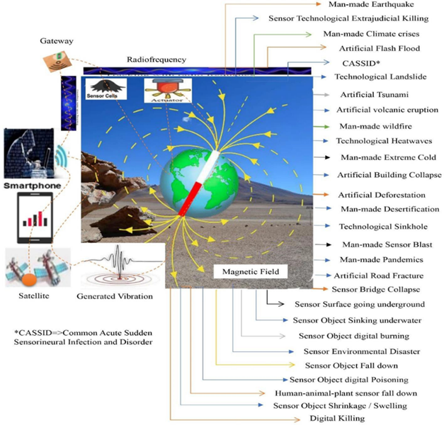
|
Figure 22 Man-Made Disasters Occurring Across the Earth |
3.12. Artificial earthquake night
The study shows that 45 earthquakes of various magnitudes occurred from January to March 2023 at specific GPS locations around the world through satellite tracking by earthquake terrorists Table 3, Table 4, Table 5.
Table 3
|
Table 3
Man-Made
Earthquakes Occurring in January 2023 |
|||||
|
Month |
Location of the Earthquake |
MMIS* |
Magnitude |
Death |
Root cause |
|
January 1, 2023 |
Jayapura, Indonesia |
Very Strong |
5.5 |
0 |
Man-made Earthquake at a
particular tectonic plate within January 2023 |
|
January 1, 2023 |
California, United States |
Very Strong |
5.4 |
0 |
|
|
January 3, 2023 |
Waikato, New Zealand |
Strong |
5.0 |
0 |
|
|
January 4, 2023 |
Central Greece, Greece |
Strong |
4.4 |
0 |
|
|
January 5, 2023 |
Badakhshan, Afghanistan |
Light |
6.0 |
0 |
|
|
January 8, 2023 |
Sanma,
Vanuatu |
Very Strong |
7.0 |
0 |
|
|
January 9, 2023 |
Maluku, Indonesia |
Strong |
7.6 |
0 |
|
|
January 10, 2023 |
Canakkale, Turkey |
Weak |
4.9 |
0 |
|
|
January 12, 2023 |
Moravian-Silesian, Czech
Republic |
Weak |
2.8 |
1 |
|
|
January 14, 2023 |
Ayacucho, Peru |
Moderate |
4.4 |
0 |
|
|
January 15, 2023 |
Eastern Visayas, Philippines |
Moderate |
4.8 |
0 |
|
|
January 15, 2023 |
Tirana, Albania |
Light |
4.7 |
0 |
|
|
January 15, 2023 |
Aceh, Indonesia |
Moderate |
6.1 |
0 |
|
|
January 15, 2023 |
Ahuachapan, El Salvador |
Very Strong |
5.2 |
0 |
|
|
January 16, 2023 |
Bonin
Islands, Japan |
Weak |
6.3 |
0 |
|
|
January 17, 2023 |
Mazandaran, Iran |
Light |
4.5 |
0 |
|
|
January 18, 2023 |
North Maluku, Indonesia |
Moderate |
7.0 |
0 |
|
|
January 18, 2023 |
West Azerbaijan, Iran |
Strong |
5.7 |
0 |
|
|
January 18, 2023 |
Gorontalo, Indonesia |
Light |
6.0 |
0 |
|
|
January 20, 2023 |
Guadeloupe, France |
Light |
6.1 |
0 |
|
|
January 20, 2023 |
Santiago del Estero, Argentina |
Weak |
6.8 |
0 |
|
|
January 23, 2023 |
West
Java, Indonesia |
Weak |
6.8 |
0 |
|
|
January 24, 2023 |
Sudurpashchim, Nepal |
Moderate |
5.4 |
4 |
|
|
January 24, 2023 |
Santiago del Estero,
Argentina |
Weak |
6.4 |
0 |
|
|
January 25, 2023 |
Sichuan, China |
Strong |
5.4 |
0 |
|
|
January 26, 2023 |
Kermadec Islands, New Zealand |
Light |
6.0 |
0 |
|
|
January 27, 2023 |
West
Java, Indonesia |
Weak |
4.2 |
0 |
|
|
January 28, 2023 |
West Azerbaijan, Iran |
Very Strong |
5.9 |
0 |
|
|
January 30, 2023 |
Puntarenas, Costa Rica |
Light |
4.5 |
0 |
|
|
*MMIS=> Modified Mercalli Intensity Scale |
|||||
From Table 3, the study shows that about 29 earthquakes occurred in different countries of the world in January 2023, with an average magnitude of 5.54 and a total death of 5. Research has revealed that cybercriminals have converted specific tectonic plates, such as West Java in Indonesia and West Azerbaijan in Iran, into earthquake simulation code, retracking the code to create artificial oscillating earthquakes in the same GPS location but at a different magnitude and in real time.
Table 4
|
Table 4 Man-Made Earthquakes Occurring in February 2023 |
|||||
|
Month |
Location of the Earthquake |
MMIS |
Magnitude |
Death |
Root cause |
|
February 01, 2023 |
Davao, Philippines |
Very Strong |
6.0 |
0 |
Man-made Earthquake at a particular tectonic plate within
February 2023 |
|
February 01, 2023 |
West
Java, Indonesia |
Weak |
4.5 |
0 |
|
|
February 04, 2023 |
Kermanshah, Iran |
Moderate |
4.7 |
0 |
|
|
February 06, 2023 |
Kahramanmaras, Turkey |
Extreme |
7.8 |
59,259 |
|
|
February 06, 2023 |
Kahramanmaras (Ekinözü),
Turkey |
Extreme |
7.5 |
||
|
February 06, 2023 |
Gaziantep, Turkey |
Severe |
6.7 |
||
|
February 06, 2023 |
Kahramanmaras (Göksun), Turkey |
Severe |
6.0 |
0 |
|
|
February 06, 2023 |
Kahramanmaras, Turkey |
Very Strong |
6.0 |
0 |
|
|
February 06, 2023 |
Malatya, Turkey |
Very Strong |
6.0 |
0 |
|
|
February 07, 2023 |
West
Java, Indonesia |
Light |
5.4 |
0 |
|
|
February 07, 2023 |
Bicol,
Philippines |
Light |
4.8 |
0 |
|
|
February 08, 2023 |
Huancavelica, Peru |
Not Felt |
3.4 |
0 |
|
|
February 08, 2023 |
Baalbek-Hermel,
Lebanon |
Weak |
4.1 |
0 |
|
|
February 09, 2023 |
Papua,
Indonesia |
Moderate |
5.1 |
0 |
|
|
February 13, 2023 |
Kermadec Islands, New Zealand |
Weak |
6.1 |
0 |
|
|
February 14, 2023 |
Gorj,
Romania, |
Very Strong |
5.6 |
0 |
|
|
February 15, 2023 |
Bicol,
Philippines |
Very Strong |
6.1 |
0 |
|
|
February 16, 2023 |
Badakhshan, Afghanistan |
Weak |
4.6 |
0 |
|
|
February 20, 2023 |
Hatay, Turkey |
Violent |
6.3 |
11 |
|
|
February 22, 2023 |
Sudurpashchim, Nepal |
Light |
4.8 |
0 |
|
|
February 23, 2023 |
Gorno-Badakhshan, Tajikistan |
Very Strong |
6.9 |
0 |
|
|
February 23, 2023 |
Adana,
Turkey |
Not Felt |
3.5 |
0 |
|
|
February 23, 2023 |
North Maluku, Indonesia |
Moderate |
6.3 |
0 |
|
|
February 25, 2023 |
Niğde, Turkey |
Very Strong |
5.2 |
0 |
|
|
February 25, 2023 |
Hokkaido, Japan |
Moderate |
6.0 |
0 |
|
|
February 25, 2023 |
West
New Britain, Papua
N. Guinea |
Strong |
6.2 |
0 |
|
|
February 27, 2023 |
Malatya, Turkey |
Very Strong |
5.2 |
0 |
|
|
February 28, 2023 |
West
Java, Indonesia |
Not Felt |
4.0 |
0 |
|
From Table 4, the study shows that about 28 earthquakes occurred in different countries of the world in February 2023, with an average magnitude of 5.53 and a total death of 59,270. Research has revealed that cybercriminals have converted specific tectonic plates, such as Kahramanmaras and Malatya in Turkey, West Java in Indonesia and Bicol in Philippines, into earthquake simulation code, retracking the code to create artificial oscillating earthquakes in the same GPS location but at a different magnitude and in real time.
Table 5
|
Table 5 Man-Made
Earthquakes Occurring in March 2023 |
|||||
|
Month |
Location of the Earthquake |
MMIS |
Magnitude |
Death |
Root cause |
|
March 1, 2023 |
West New Britain, Papua New Guinea |
Weak |
6.6 |
- |
Man- made Earthqu ake at a particul
ar tectonic plate within March 2023 |
|
March 2, 2023 |
Strong |
6.5 |
- |
||
|
March 2, 2023 |
Andhra Pradesh, India, |
Not Felt |
3.8 |
- |
|
|
March 4, 2023 |
Kermadec Islands offshore, New Zealand, |
Moderate |
6.9 |
- |
|
|
March 5, 2023 |
Davao, Philippines, |
Strong |
5.4 |
- |
|
|
March 7, 2023 |
Davao, Philippines, |
Very Strong |
5.9 |
- |
|
|
March 9, 2023 |
Umbria, Italy, |
Light |
4.3 |
- |
|
|
March 9, 2023 |
Umbria, Italy, |
Very Strong |
4.5 |
- |
|
|
March 10, 2023 |
Santander Colombia |
Light |
5.4 |
- |
|
|
March 14, 2023 |
Madang offshore, Papua
New Guinea, |
Light |
6.3 |
- |
|
|
March 16, 2023 |
Kermadec Islands offshore, New Zealand |
Light |
7.0 |
- |
|
|
March 16, 2023 |
West Azerbaijan, Iran, |
Strong |
5.2 |
- |
|
|
March 18, 2023 |
Guayas offshore,
Ecuador |
Very Strong |
6.8 |
18 |
|
|
March 21, 2023 |
Badakhshan, Afghanistan |
Moderate |
6.5 |
21 |
|
|
March 22, 2023 |
Jujuy, Argentina |
Light |
6.4 |
- |
|
|
March 22, 2023 |
Sughd, Tajikistan |
Very Strong |
5.8 |
- |
|
|
March 24, 2023 |
West Azerbaijan, Iran |
Very Strong |
5.6 |
- |
|
|
March 27, 2023 |
Isabel offshore, Solomon Islands |
Moderate |
6.2 |
- |
|
|
March 28, 2023 |
Hokkaido offshore, Japan |
Light |
6.1 |
- |
|
|
March 29, 2023 |
West Java,
Indonesia |
Light |
4.0 |
- |
|
|
March 30, 2023 |
Maule offshore,
Chile |
Moderate |
6.3 |
- |
|
|
March 31, 2023 |
Balochistan, Pakistan |
Moderate |
3.4 |
3 |
|
From Table 5, the study shows that about 22 earthquakes occurred in different countries of the world in March 2023, with an average magnitude of 5.68 and a total death of 42. Research has revealed that cybercriminals have converted specific tectonic plates, such as Davao in Philippines, Umbria in Italy, Kermadec Islands in New Zealand and West Azerbaijan in Iran, into earthquake simulation code, retracking the code to create artificial oscillating earthquakes in the same GPS location but at a different magnitude and in real time. From January 1, 2023 to March 31, 2023, about 79 earthquakes occurred worldwide, with an average magnitude of 5.58 and a total of 59,275 deaths, as shown in Table 6.
Table 6
|
Table
6 Status of Occurring
Earthquakes from January 2023 to March 2023 |
||||
|
Parameters |
2023 |
Status |
||
|
January |
February |
March |
||
|
Earthquakes |
29 |
28 |
22 |
Artificial earthquakes were maximum in January. |
|
Avg. Magnitude |
5.54 |
5.53 |
5.68 |
Highest magnitude showed in March |
|
Total death |
5 |
59270 |
0 |
Highest death occurred in February |
All of the people and animals panicked when this earthquake happened suddenly and they became more depressed when their houses were destroyed by the earthquake. Victims spend the night under the open sky this is when artificial flash floods are triggered by cybercriminals in earthquake-prone areas. The cruel irony of the victim's fate begins - hour of disaster, darkness all around, no electric light - dark night of new moon, with wild animals and theft of victim's property by cybercriminals. This is the brutality of artificial earthquake night.
3.13. Worldwide Oscillated Earthquake
The study shows the status of global earthquakes from 2013 to 2022 as shown in Figure 23. Other ranges of dimensions are also shown in different sections:
1) A maximum of 2046 earthquakes in 2021 and a minimum of 1315 in 2020, with a magnitude range of 5.0–5.9,
2) A maximum of 143 earthquakes in 2014 and a minimum of 104 in 2017, with a magnitude range of 6.0–6.9,
3) Maximum 18 earthquakes in 2015 and minimum 6 in 2017, with magnitude range 7.0-7.9,
4) No earthquakes with relevant magnitude occurred in 2016, 2020 and 2022.
Figure 23
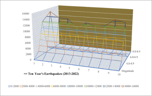
|
Figure 23 Worldwide Oscillated Earthquake Status from the year of 2013 to 2022. |
3.14. Man-made Oscillated Earthquake
The study shows man-made earthquakes caused by cybercriminals at a specific GPS location through satellite oscillations, as shown in Figure 24. Research shows that tracking with satellite technology towards certain tectonic plates increases the number of man-made earthquakes around the world. The research included wireless sensor cells and actuators to enhance electromagnetic needles and electromagnetic bubbles. The study created a large noise from an electromagnetic bubble above the land surface to create a "fault" via satellite tracking. In the study, the point as epicenter was chosen as the fault center of the tectonic area. Two electromagnetic needles are inoculated underground through the epicenter to establish the hypocenter. These two centres created a transition beam to automatically generate vibrations from hypocenter to epicenter. As the gravity sensor is activated, the beam vibrates at a certain distance from the tectonic plate. This generated vibration continues to depend on the high radio frequency range. RFID devices measure the fluctuations of radiofrequency linking with magnitude and a Modified Mercalli Intensity scale.
Figure 24
|
Figure 24 Man-made Oscillated Earthquake at particular GPS Location |
3.15. Artificial Landslide
The study showed that artificial landslides occurred at specific GPS locations and GNSS locations due to processed satellite device tracking, which is shown in Figure 25. The results reflect the climate crisis due to misuse of advanced satellite technology. The study provided images of landslides, which occurred in hilly areas, roads, highways and riparian zones, riparian areas and other climatic zones through advanced satellite cloud tracking systems. Suddenly there is a terrible sound and noise before the landslide starts.
Figure 25
|
Figure 25 Man-Made Landslide at Particular GPS Location |
3.16. Sensor Road Surface Fracture
Research has shown that tracking a specific GPS location with advanced wireless sensor technology results in sudden cracks in the road surface, as shown in Figure 26. Studies have shown that the application of the Lorentz force connecting ISNAPHO to the road surface. The study also found that tracking with ISNAPHO can cause any road surface to suddenly collapse or erupt violently. As tracking increases in the radio frequency range, the road surface will crack to a greater depth. Furthermore, due to tracking, the electromagnetic needle is drawn to a certain depth below the road surface, so that the active sensor cells, actuators and gateways can collectively cause cracks in different parts of the road, which will cause a dangerous accident on the active road. Cybercriminals create artificial earthquakes by tracking the path of tectonic plates at specific GPS locations. This is a misuse of advanced satellite technology to remind present and future generations—technology's detriment to human well-being.
Figure 26
|
Figure 26 Sensor Road Surface Fracture at a Particular GPS Location Due to Tracking with High Radiofrequency Satellite Oscillators. |
3.17. Sensor Building Collapse
Research has shown that tracking a specific GPS location with advanced wireless sensor technology can cause standing buildings to suddenly collapse, as shown in Figure 27. Studies have shown that ISNAPHO can be associated falling with residential buildings in certain areas due to Lorentz forces. The study also found that tracking with ISNAPHO can cause buildings in any residential area to suddenly collapse one after the other or explode violently. As tracking increases in the radio frequency range, cracks in large buildings and walls along with standing buildings will also damage. In addition, due to tracking, the electromagnetic needle is inserted to a certain depth under the residential area, so that the active sensor cells, actuators and gateways can collectively cause cracks in different parts of the building or sink underground and cause many casualties, which is a dangerous situation in the residential area. Cybercriminals in cloud networks can create artificial earthquakes by tracking the path of tectonic plates in specific residential areas. Misuse of Advanced Satellite Technology to Remind Generations of Logical Destruction - Unsafe Technology Harmful to Human Welfare.
Figure 27
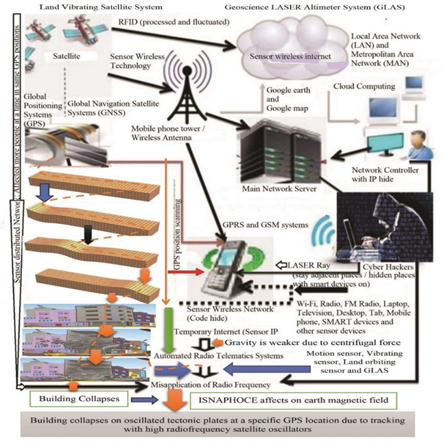
|
Figure 27 Sensor Building Collapse at a Particular GPS Location Due to Tracking with High Radiofrequency Satellite Oscillators. |
The study also shows that any building at a specific GPS location can instantly collapse, destroy, damage, burn, or tilt due to wireless sensor tracking whether or not an earthquake occurs immediately.
3.18. Sensor Bridge Collapse
The study has shown that tracking a specific GPS location with advanced wireless sensor technology can cause the connecting bridge to suddenly collapse, as shown in Figure 28. Studies have shown that ISNAPHO can be damaging to bridges connecting certain roads or areas due to Lorentz forces. The study also found that tracking with ISNAPHO could cause any road / highway bridge to suddenly collapse one after the other or explode violently. Cracks in major bridges and culverts as well as busy highways will be affected as tracking increases in the radio frequency range. In addition, due to tracking, the electromagnetic needle is inserted to a certain depth under the bridge areas, so that the active sensor cells, actuators and gateways can collectively cause cracks in different parts of the bridge or fall down and cause many casualties, which is a dangerous situation on the highway. Cybercriminals in cloud networks can create artificial earthquakes by tracking the path of tectonic plates in certain bridge areas. Misuse of Advanced Satellite Technology to Remind Generations of Unwanted Fallout - Unsafe Technology Harmful to Human Well-Being.
Figure 28
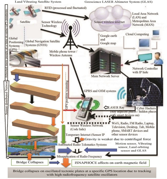
|
Figure 28 Sensor Bridge Collapse at a Particular GPS Location Due to Tracking with High Radiofrequency Satellite Oscillators. |
3.19. Sensor Land Surface Going Underground
The study shows that specific land surface is submerging due to wireless sensor tracking at specific GPS locations, which is shown in Figure 29. Research has shown that centrifugal pressure is applied by tracking gravity sensors through satellite technology with specific focus pointers towards specific land surfaces in selected surroundings. Area studies included wireless sensor cells with actuators due to applications with electromagnetic needles and electromagnetic bubbles. The study made a big noise from an electromagnetic bubble above the Earth's surface creating "undulations" through satellite surface tracking. In the study, the undulation surface was chosen and virtualized as the subsurface of the tectonic area. Two electromagnetic needles are inoculated through the focus pointer into the subsurface to fluctuate the surface area. This surface field automatically creates undulations with electromagnetic bubbles to generate subterranean vibrations from the focus pointer, creating subterranean voids. As the gravity sensor is activated, a certain distance from the tectonic area vibrates and the area slowly moves underground. These generated ground undulations depend on the high radio frequency range. RFID devices activate high radio frequency ranges, underground passageways cause sudden cracks in the ground surface due to high radio frequency fluctuations, as the cloud network activates, the cracks gradually enlarge to form tunnels. Thus, the land surface is driven underground by satellite tracking. But many think it is a natural change. The study reveals that their idea is wrong. This study is instructive for all.
Figure 29
|
Figure 29 Sensor Land Surface Going Underground at a Particular GPS Location Due to Tracking with High Radiofrequency Satellite Oscillators. |
3.20. Object Sinking under water
The study has shown that a small boat with a cat was floating in UNIMAS Lake at a specific GPS location. While tracking the boat with an atom-based gravity sensor as it floats for a while, the boat tilts and sinks into the lake water, causing the cat to quickly sink as shown in Figure 30.
Figure 30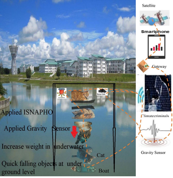
|
Figure 30 Applied ISNAPHO with Gravity Sensor to Sink Cat and Boat Under Water at a Particular GPS Location. |
The cat's retina was scanned earlier, so the cat quickly moved underwater as the sensor applied gravity. No matter how underwater the cat goes, it can be controlled via satellite-based voice coding and retina scanning code in a cloud network. Thus, any object exposed to water can be submerged by gravity sensor tracking. It is time sensitive to oxygen and water depth. Studies show that when a moving submarine sinks into the water, tracking with wireless sensors blocks the submarine's vehicle identification number, rendering the engine fan useless. And through the magnetic receptors, the entire submarine in the water is deactivated and all the people inside it are also immobilized through the sensor receptors. Because, inside the submarine, all the people's eyes were open, their voices were active, mobile phones were on, sensor cameras or devices were active - so that the tracking position of the passengers could be determined and as a result of this tracking, everyone was paralyzed or numb. In this case, the passengers knew how to swim but were unable to swim as each of their limbs was paralyzed by wireless sensor tracking. The sensor then applies a gravitational force to the idling submarine - causing the submarine to gain weight, i.e., increase density and decrease buoyancy. Therefore, the pressure in the submarine is greater than that of the water. Through wireless sensor tracking in deep water, the submarine's air cooler shuts off and the internal temperature suddenly rises. This causes the submarine to become dull and lose its rigidity. After that, when the sensor exerts centrifugal force, the submarine sinks deeper underwater. Applying massive pressure to an inactive submarine connected to the cloud network instantly causes the submarine to implode, dispersing all the people inside. As a result, the internal pressure of the sinking submarine increases rapidly through retracking. A burst of pressurized air instantly plunged the submarine into deep water. All of them could not move or swim as their whole-body including arms and legs were paralyzed. Within moments, all people drowning in deep water die from lack of oxygen. Thus, wireless sensor tracking on ships, other submarines, boats, launches, steamers and speed boards causes immediate accidents, property damage and loss of lives.
3.21. Risk Factors of Man-made Earthquake
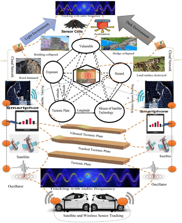
The study shows the risk of man-made earthquakes on certain tectonic plates due to tracking with advanced satellite technology. These tectonic areas are located on the campus of UNIMAS, Malaysia, which have been examined through ISNAPHO. Buildings are vulnerable for several reasons due to tracking with high radio frequency sensor devices. Risks include man-made earthquakes, flash floods, wildfires, digital pollution sensor, artificial landslides, social hazards, sudden heatwaves, loss of biodiversity through wireless tracking, spread of environmental diseases, technological pandemics and health vulnerabilities, etc. Nevertheless, for educational, economic, social, communication, environmental, technological and service reasons, UNIMAS campus settlements are developed without residential or private network area control units and artificial earthquake mitigation systems. The challenges of the tectonic zone in this area have led to the unexpected growth and unplanned expansion of unsafe satellite technology in the absence of effective security measures. Rehabilitating these areas and reducing their potential hazards by ensuring advanced satellite technology for safe, risk-free and earthquake mitigation dynamic and eco-friendly users. The UNIMAS campus is mostly built according to traditional engineering concepts without following the standards of Campus Area Network Control Unit or Student Residential Area Network Control Unit. Still there is a risk of man-made earthquakes in the studied area. The study shows the risk factors of man-made earthquakes including insecure tectonic plate, misuse of satellite technology, hazards, exposure and vulnerability, which as shown in Figure 31. The study reveals that on hazards as risk factors including (i) man-made hazards, (ii) natural hazards, (iii) biological hazards, (iv) environmental hazards, (v) socio- natural hazards, and (vi) technological hazards in man-made earthquake. The study also demonstrated diverse risk factors from man-made earthquakes, namely: (a) Instant digital killing through wireless sensor tracking, (b) Persons with physical disability at earthquake areas, (c) Misuse of advanced satellite technology, (d) Easy access to insecure particular GPS location, (e) Insecure tectonic plate, (f) Young children and old aged persons during oscillated tectonic plate, (g) Women in pregnancy, (h) Serious patient in palliative care, (i) Sudden man-made earthquakes pose a serious risk to narcolepsy patients with cataplexy.
Figure 31
|
Figure 31 Risk Factors in Man-Made Earthquake |
3.22. Who are Earthquake Terrorists?
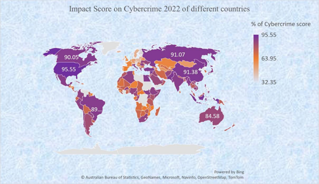
The study showed that earthquake terrorists involved in cybercrime around the world. Research has shown that earthquake terrorists are involved in cybercrimes across the Earth. The study also revealed that almost every country was affected by cybercriminals in 2022, but the worst impact was in the United States (impact score 95.55%) and the least impact was in Norway (impact score 32.35) as shown in Figure 32. Research has shown that earthquake terrorists are a group of cybercriminals located on Earth with cloud networks. Research has shown that Md Hatem Ali, Md Jashim Uddin and Md Nizamuddin were the chief executives of this cybercriminal group. Their collaborative cyber team is stationed at various GPS locations to track man-made earthquake sequences for a particular country. The research involved retinal scanning of the individual, voice coding, active wireless sensor devices and tracking of a specific GPS location. Multi- layered neural networks and multi-operating systems also help identify cybercriminals at a specific location.
Figure 32
|
Figure 32 Impact Score on Cybercrime 2022 of Different Countries |
The top-ten worst cybercrime affected countries, which as shown in Table 7. These countries are affected severely by man-made disasters including earthquakes, flash flood, tsunamis, landslides, wildfires and pandemics.
Table 7
|
Table 7 Name of the Top Ten Worst Cybercrime Affected
Countries |
|||
|
Name of country |
Score of Cybercrimes |
Ranks |
Affected |
|
United States |
95.55 |
Severe Cybercrime |
Severe affected by man-made
disasters including earthquake, tsunami, flash flood, landslide, climate
crises, environmental diseases, wildfire, pandemics, digital stealing and
extrajudicially digital killing |
|
Indonesia |
93.16 |
|
|
|
China |
91.38 |
|
|
|
Pakistan |
91.34 |
|
|
|
Russia |
91.07 |
|
|
|
Greece |
90.81 |
|
|
|
Turkey |
90.40 |
|
|
|
Syrian Arab Republic |
90.37 |
|
|
|
Canada |
90.05 |
|
|
|
Brazil |
89.85 |
|
|
Research shows that earthquake criminals are located in high numbers in the top ten worst cybercrime countries. These criminals can cause earthquakes or other disasters in pandemic form in these countries at any time, as happened in the Turkey-Syria earthquake on February 6, 2023. Because, cybercriminals have developed Earthquake Simulation Code (ESC) of many countries around the world by coding into satellite devices, just waiting for the satellite to track to a specific GPS position on the specified tectonic plate and magnitude scale. Administration, policy makers and experts can play an important mitigating role in this regard.
3.23. Earthquake Perception
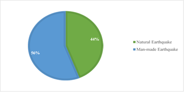
Studies have shown that sudden and frequent earthquakes are a cause of concern for living in today's world. Many respondents say that if this earthquake is not mitigated immediately, there will be a catastrophic disaster. Currently, all the earthquakes happening in the world are man-made, that is, earthquake terrorists are misusing advanced satellite technology to cause these disasters. The survey also shows that 56% of the respondents think that the current earthquakes are artificial or man-made, and 44% of the respondents think that they are natural, as shown in Figure 33. The survey also revealed that very few respondents were convinced of natural earthquakes. Some of them say that earthquakes are the revenge of nature - the result of human misdeeds. Again, another respondent group says, if the misuse of satellite technology is not controlled, soon the entire world will be subjected to digital torture of humans, animals and plants by earthquake criminals through artificial earthquakes, which will be so terrible that everything on Earth will be destroyed. Land surface will be inverted by satellite tracking. And the habitable earth will turn into a hole. Although some respondents are still not fully convinced of artificial earthquakes, the day it will be revealed the horrors of man-made disasters, this study will be the best witness to all.
Figure 33
|
Figure 33 Respondents Perception on Man-made Earthquake and Natural Earthquake |
3.24. Risks in Seismic Zone
Bangladesh is divided into three seismic zones. Some places in North-Eastern and South-Eastern regions such as: Sylhet, Rangamati, Bandarban, Cox's Bazar are the most vulnerable zones. Bangladesh map shows areas marked in red as more vulnerable. Dhaka and Chittagong medium risk - Areas marked in pink on the map of Bangladesh are shown as medium risk. Again, the West and South-West regions are identified as the least vulnerable – areas marked in yellow on the map of Bangladesh are shown to be least vulnerable in Figure 34.
A sudden earthquake in Turkey and Syria on February 6, 2023, considered one of the worst in recent times, had a magnitude of 7.8. Scientists say that this terrible earthquake occurred when the Arabian plate under the ground of the area moved northwards and pushed against the Anatolian plate. But research says that this statement of scientists about earthquakes is completely false, as cybercriminals misuse human-made satellite technology to cause these earthquakes. It took six days for the Creator to create this world - a creation so perfect and wonderful that no human society could be harmed by hitting it directly on a plate. It involves human error, which is known in research. The Earth's surface is made up of separate bits, or tectonic plates, that float on top of the soft material below. There are seven major such plates and numerous smaller sub-plates all over the Earth. There are several countries and regions of the world that are located around large plates or sub plates. Bangladesh is one such country. Burma plate and India plate are located near Bangladesh. As a result of the change in the position of these plates, experts fear that earthquakes of more than eight magnitude may occur in this region. Research shows that Bangladesh is unlikely to experience earthquakes, although some experts are predicting high-magnitude earthquakes in the region - either experts are wrong or cybercriminals are inciting falsehoods to spread fear among the public, according to the study.
Figure 34
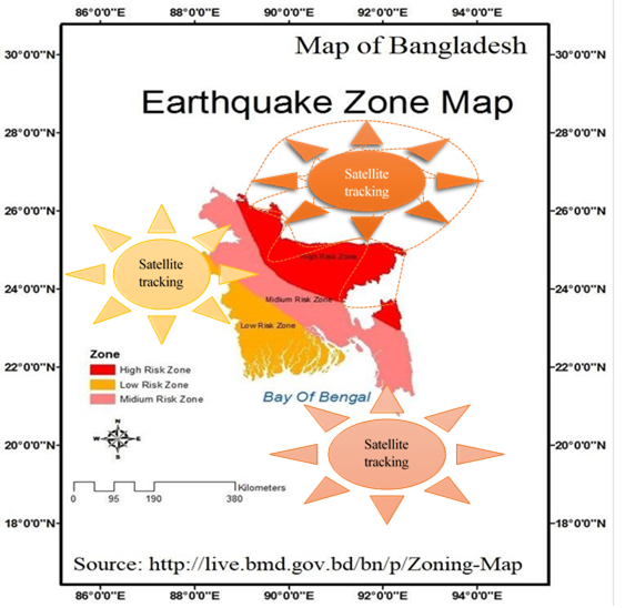
|
Figure 34 Seismic Zones in Bangladesh |
The researchers think that this innovative study will open the eyes of all conscious people, they will understand the main cause of excessive earthquakes, flash flood Miah et al. (2023h), landslides and relevant man-made disasters around the world. The research shows that using advanced satellite technology, earthquakes can be created in time on any tectonic plate on Earth. This is highly innovative research - no doubt about it. However, the question remains that when technology was not invented, but earthquakes occurred - which were natural. Humans now generate artificial oscillations at specific GPS locations through earthquake simulation code by multiplying the magnetosphere of previous earthquakes’ magnitude.
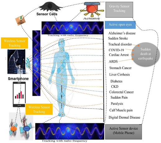
3.25. Digital Killing in Seismic Areas
The study shows ISNAPHO testing digital kills in earthquake-prone areas. Due to tracking with an advanced wireless sensor device to the individual at a specific GPS location, he is suffering from CASSID (Common Acute Sensorineural Sudden Infection and Disorder), especially Alzheimer's disease, sudden stroke, tracheal disorder, COVID-19, cardiac arrest, ARDS. (Acute respiratory distress syndrome), stomach cancer (other cancers also), liver cirrhosis, diabetes, CKD (chronic kidney disease), colorectal cancer, sudden pain (back pain, lumbago, shoulder pain, hip pain), paralysis (numbness, facial palsy), calf muscle pain, and digital skin diseases (eczema, dermatitis), as shown in Figure 35. Studies show that respiratory disorders, covid-19, cardiac arrest and ARDS occur in sudden death in seismic zones. Studies have shown that earthquake criminals are extra judicially killing famous people or activists by tracking wireless sensors to a specific GPS location in earthquake-prone areas.
Figure 35
|
Figure 35 Digital Killing Diseases Due to Wireless Sensor Tracking at Seismic areasq1 |
3.25. Inference
3.25.1. Formula for Artificial Earthquake
From the above results, the study developed a formula for artificial earthquakes:
Due to the active satellite network, each object on the tectonic plate or part of the tectonic plate generates artificial earthquakes through high radio frequency tracking at a specific GPS location.
From the formula, the study illustrates all the earthquakes in the world today are man-made, which is proved scientifically, justified methodologically and applied ecologically. Since a tectonic plate accompanies an electric impulse due to cloud satellite tracking at a particular GPS location moving charge to radiate spontaneously the greater wave and the greater the tectonic plate.
3.25.2. Main Facts in Artificial Earthquake
Studies have shown that artificial earthquakes are among the deadliest man-made disasters. Earthquake terrorists set specific dates, times and satellite networks to strike specific urban areas with earthquakes. Before triggering an earthquake, earthquake terrorists hide in various locations in nearby cities with specific GPS locations through cloud networks. Cyber terrorists sign a deal with the main political leader as the ruling government of a particular country to get satellite network connections on the condition that the cyber terrorists will win the contracted political party in the next national election and the elected government will keep all their crimes secret. When the Chief Political leader of the Ruling Party elected as government in general election with the help of cybercriminals, then cybercriminals have been occurring continuously artificial earthquakes and other man-made disasters across the globe.
4. Discussion
The study shows that man-made earthquakes are vulnerable in densely populated areas due to faults and fractures at a specific GPS location. Studies have also shown that the existing fault is at high risk of a major earthquake resulting from strong tremors in densely populated and industrialized areas Field et al. (2009); Hole (2011); Olsen et al. (2006); Weldon et al. (2005). The study reveals that artificial earthquake fracture zones are a linear feature of the tectonic floor – often hundreds, even thousands of kilometers long – that result from satellite tracking of the activity of offset mid-tectonic ridge axis segments. The impacts of man- made earthquakes are detailed with various parameters.
4.1. Impact of Man-made Earthquake
Earthquakes are one of the major disasters caused by sudden movements of tectonic plates within the Earth's crust Zafar and Afzaal (2017). So, the impact of man-made earthquake is dangerous due to its magnitude Ellidokuz et al. (2005). Studies have shown that the impact of man-made earthquakes is so severe that it is difficult to express in words Miah et al. (2021f). People will panic if they know this dire effect without safety and security of life in earthquake prone areas, particularly building collapsed in sudden earthquakes, details in video: https://www.youtube.com/watch?v=buLMbZhp5rI. As the radiofrequency level increases 0during satellite tracking, the damage increases. On tectonic plates where earthquakes occur, high radiofrequencies can be used to instantly destroy everything or even overturn the area. As a result, no existence of people, animals, plants, buildings and other resources can be thought of in that area. But the lesson for the thoughtful is that the impact of a man-made earthquake like Turkey could be devastating, taking the world by surprise, more details in this video: https://www.youtube.com/watch?v=IiDvo-xTinY.
The primary cause of earthquake-related deaths was trauma due to building collapse and digital tracking, and the very young and elderly were at increased risk of death Doocy et al. (2013). Moreovcer, man-made effects of earthquakes include ground shaking, surface faults, ground failure, landslides, tsunamis, liquefaction, sudden injuries and deaths, loss of biodiversity Miah et al. (2018); Miah et al. (2023c); Miah et al. (2023d); Miah et al. (2023i); Miah et al. (2022c); Miah et al. (2021f); Miah et al. (2021h); Miah et al. (2019); Miah (2013); Miah et al. (2018); Miah et al. (2023j), widespread house destruction, disruption of transport and communication links, rupture of water and gas pipes, electrical load shedding, disruption of Mobile networks, contaminated water supplies, flash floods Miah et al. (2023h), outbreaks of pandemics Miah et al. (2023), resettlement of people, overnight stays in their own cars or vehicles, sometimes sleeping rough in refugee camps or temporary shelters. Poverty increases the risk of injury and damage caused by sudden artificial earthquakes. For this reason, man-made earthquake risk assessment is essential in disaster management.
4.2. Why Man-made Earthquakes occur
Earthquakes are generally natural - everyone admits that. But research shows that humans can use advanced satellite technology to trigger earthquakes on stationary tectonic plates Miah et al. (2021f). When there was no satellite technology, there were still a few earthquakes. The study found that 29 earthquakes occurred in January 2023, 28 in February including Turkey-Syria, details magnetic field to occur earthquake from the video of Global News: https://www.youtube.com/watch?v=Da6pa_KW1EM, and 22 in March, surprising the world on artificial earthquake. The Creator (Allah) does not wish to afflict mankind (slaves) with so many earthquakes as the best of creation, because, Allah says, "I am not oppressor to slaves" Surah Qaaf , Verse 29. So, so many earthquakes are caused by man-made disasters. The Creator also says - "Disaster has spread on land and water because of what people have done" Surah AR-Rum, Verse 41. Advanced satellite technology is expanding in the interests of science, and a class of cybercriminals is abusing this technology to create an artificial catastrophe - an invisible fear among all creatures on Earth. Through advanced technology, people can know the radiofrequency of previous earthquakes. They record the magnitude of tremors during these earthquakes. Meanwhile, many other technologies including GPS/GNSS digital exponential, Maxwell's law, Lorentz's law, gravity sensors and advanced satellite technologies including the High Frequency Active Aural Research Program (HAARP), fluxgate magnetometers and VHF-radar. These are integrated as built-in devices. Humans record radiofrequencies when natural earthquakes occur and programmatically multiply these radiofrequencies into earthquake simulation codes that are converted into earthquake-like peak vibration codes. Artificial seismographs produce high radiofrequency waves at the GPS locations of specific tectonic plates, resulting in satellite- induced man-made earthquakes, which cause extensive property damage and the deaths of millions of lives. Man-made earthquakes are a global technological enemy that will destroy everything on earth in future pandemics if not properly countered.
4.3. Digital Torture
During man-made earthquakes, cybercriminals carry out digital torture on people in certain areas. Due to this, women, men, children and other animals of the area are spending sleepless nights and their mental health is seriously affected. Cybercriminals active in cloud networks use electromagnetic needles and electromagnetic bubbles to digitally torture people, animals, plants and objects through wireless sensor tracking, causing physical harm and sleepless nights - some of them get sick, some die and some get digital burns Miah et al. (2023d). So, it is said that digital torture is more dangerous than police remand. Although it is invisible but connected to the cloud network at a specific GPS location, which cybercriminals digitally harass everyone in the vicinity. These tortures include digital poisoning, pain, burns, blocks, benign tumor, malignant tumor, sudden fever, chronic insomnia, narcolepsy, schizophrenia and mental depression with fluctuating body electron movement. This digital torture is the initial phase of CASSID (Common Acute Sudden Sensorineural Infection and Disorder). Cybercriminals' digital tyranny has forced many politicians to leave party politics and join other parties, while their digital tyranny has forced some presidents or prime ministers to retire from state power to sleep well because they suffer long periods of chronic insomnia due to wireless sensor tracking, for example, the resignation of New Zealand prime minister Jacinda Ardern on January 19, 2023 Oliver (2023). Research shows that even the nation's respected chief executives are vulnerable to cybercriminals due to misuse of wireless sensor technology.
4.4. Uniqueness in Research
The study shows innovative concepts and unique results of man-made earthquakes with dynamic potential in the global field. The study is a world-leading disaster research that can inform policy-makers for mitigation and management of man-made earthquakes Miah et al. (2021f). Most people in the world think that earthquakes are natural, but they are wrong. Due to advanced satellite technology tracking towards particular tectonic plates, artificial earthquakes occurred at a specific GPS location, in details from this video of TRT World: https://www.youtube.com/watch?v=9jIsdk8Ck-4. For this reason, the research is unique worldwide.
4.5. Political Earthquake
Research shows that cybercriminals want to collude with the government because it will use advanced wireless sensor technology to suppress the opposition, so that the government is long-term and no one can protest against the government's misdeeds and corruption. If the ruling government doesn't agree, cybercriminals make deals with the opposition on the condition that they abuse wireless sensor technology to oust the government and bring the opposition to power. If the opposition does not agree to their proposal, the cybercriminals try to compromise the country's army chief on the condition that, by abusing wireless sensor technology, they will remove the government from power and make the army chief the head of government and this power will be long-term. The study also shows that when the head of government, army chief and opposition leaders do not admit the misdeeds of cybercriminals, the cybercriminal chief gets angry with them and creates misdeeds and artificial disasters at various levels to question the upcoming national elections. In particular, it is causing severe earthquakes in the country Miah et al. (2021f), extrajudicial killing of top leaders in digital tracking Miah et al. (2021); Miah et al. (2023e), destroying the national economic system, causing severe inflation, increasing the prices of daily commodities, breaking the network system Miah et al. (2021a), causing wildfire and heatwaves Miah et al. (2022f) and causing outbreaks of pandemics Miah et al. (2022); Miah et al. (2022a) due to tracking with advanced wireless sensor technology. For example, earthquakes in Turkey are caused by the relative motion of the large Arabian, Eurasian and African tectonic plates and a smaller Anatolian tectonic block USGS. (2023a). Political impact from earthquake is in details from the video of euronews: https://www.youtube.com/watch?v=uEDlMMJ5f64
4.6. Digital traps in the revolutionary journey
A submersible vessel taking five tourists on a deep ocean journey to view the wreckage of the Titanic went missing on June 18, 2023. The tourists in Titan were Hamish Harding, Shahzada Dawood, Suleman Dawood, Paul-Henri Nargeolet and Stockton Rush. A perilous journey under the sea is observed through the disappearance of the Titan submarine to view the wreckage of the Titanic, more details in the video of MSNBC: https://www.youtube.com/watch?v=Vi3AE7PKnVY. Tourists' lives are at grave risk on this trip. Even after many searches at the bottom of the sea, no trace of them can be found. This risk is misuse of geographic positioning satellite technology. Cybercriminals have developed this sensor technology abuse to digitally hijack tourists. Because the tourists were traveling under the sea with their eyes open, mobile phones turned on, they were talking to specific GPS locations, and the Titan submarine was in a specific location, which followed the ISNAPHO effect. No Advanced GPS Area Network Control Unit in Titan, for this reason cybercriminals can attack the Titan with wireless digital poison. Similarly, another submarine tragedy occurred in Indonesia in 2021, where the same technology was misused.
Cybercriminals set up digital traps on water, land and air with the help of advanced satellite technology. Due to this, many rich people and talented scientists are held hostage in the digital trap in different countries of the world. The same thing happened to the five tourists on the Titan - digital murder via wireless sensor tracking. For this, cybercriminals disable the Titan's engine fans by tracking satellite sensors, thereby disabling the entire Titan. A downward centrifugal force is exerted by re-tracking the stationary Titan—so that the heavier Titan falls under the water according to the laws of gravity. Due to the idling of the engine's fans and wheels, the tourists' lack of oxygen under the water increases. By tracking again, the whole body of the tourists including hands and feet becomes paralyzed, as a result the tourists cannot move, within a while everyone starts having trouble breathing. Moreover, their lives are at risk as the entrance gate to Titan is closed from the outside. Tourists are tracked by wireless sensors as they speak with their eyes open and self-voice and become digitally ill with sudden respiratory distress, ARDS or cardiac arrest Miah et al. (2023d). Research shows that tourists digitally die inside Titan within 5-25 minutes when wireless tracking is turned on due to misuse of cloud satellite networks. Cybercriminals are then tracked to the Titan by a sensor bust, causing a catastrophic implosion and the Titan shattering into pieces underwater. Not only titan implodes, but also boats, launches, steamers or ferries can sink inside huge bodies of water due to wireless sensor tracking to a specific GPS location, more details from the video of South Korea Ferry Disaster: https://www.youtube.com/watch?v=5_A8dq2fA5o.
Similarly, wireless sensor tracking led to submarine accidents in Indonesia and digital deaths of crews. By misusing this technology, planes flying in the sky crash, accidents occur in moving buses or cars, derailments of moving train carriages occur, ferries floating in rivers sink, even people suddenly fall while walking or climbing hills, or walking on the stairs - such an incident happened during the visit of US President Joe Biden to Poland. The President Joe Biden stumbled in the steps of Air Force One due to wireless sensor tracking as he leaves Poland on February 22, 2023 after delivering a historic speech in the gardens of the Royal Castle in Warsaw Sky News (2023). The Titan crashes in different ways, like- the Titan has a Vehicle Identification Number (VIN) - which is displayed as the sensor scans, the passenger has a photoreceptor code - which detects body position with the sensor cell and the passenger has an active sensor device - which detects the IMEI code. To help tracking, Titan's touchscreen computer has MAC numbers for administrative real-time. Thus, the entire process is tracked by the built-in sensor device and the simulation coding is distributed through the cloud network. This code is misused to hide, sick, crack, burn, overturn or throw away people or objects at a specific location. Similarly, boats or ships floating in water are instantly sunk by wireless sensor tracking. The same happens when a person, pet or wild animal bathes or swims in a pond, river, lake or ocean, cybercriminals track the person's entire body including arms and legs to paralyze the person, causing the paralyzed body to fall under the water, or the body is submerged elsewhere in the stream. A drowning person's limbs are paralyzed, making it impossible for him to swim and he dies instantly from lack of oxygen. As tourists were under the control of cybercriminals from June 18, 2023 to June 22, 2023 with cloud network zone. Both the tourists and the Titan suffer due to wireless sensor re-tracking by cybercriminals – a pre-planned and technological death trap. An unfinished journey through this trap ends heartbreakingly. It is a historical tragedy - similar to the fate of the Titanic that befell the Titan submersible.
Another example of a plane crash missing from the study is noted, which occurred on 08 March 2014. Research has shown that, MH370, a scheduled passenger flight operated by Malaysia Airlines (MAS), disappeared 39 minutes after taking off from Kuala Lumpur to Beijing, with a total of 239 people on board, including 12 crew and 227 passengers. The aircraft operating the flight was a Boeing 777-200 ER, registered as 9M-MRO SIT. (2018). This is the misuse of gravitational force with advanced satellite technology.
On 24 April 2021, Indonesian authorities announced that the navy submarine Nangala-402, which went missing on 21 April while conducting a naval exercise, had sunk. Despite an intensive search and rescue operation involving the naval assets of Singapore, Australia, India, Malaysia and the United States, the submarine was never found. Its wreckage was later discovered on 25 April 800 meters below sea level. All 53 people on board died, including the Navy's submarine unit commander Nugroho and Marzuki (2021). This is also the misuse of gravitational force with advanced satellite technology.
Finally, cybercriminals have in the past set many such digital traps at specific GPS locations on Earth. A lot of damage to common people and valuable property has been caused by them. Although they were very powerful and tyrannical, but after a time when people came to know about their misdeeds, all cybercriminals were immediately caught and prosecuted. Today they all remember them with contempt and disdain. Studies have shown that digital traps have caused many fatal accidents involving ships, submarines, aircraft, helicopters and other vehicles around the world, and the root cause of these accidents remains a mystery due to the limited knowledge of some people, resulting in the misdeeds of cybercriminals not being easily uncovered, namely, the 1912 Titanic disaster, the root cause of AIDS, pandemic plague and the origin of the coronavirus are still unknown to many. According to Miahv et al. (2023), Miah et al. (2022), Miah et al. (2022a) cybercriminals caused these fatal accidents by tracking wireless sensors to specific GPS locations before or after an artificial earthquake. This study unmasks the cybercriminals - who are the main culprits of these accidents.
Figure 36
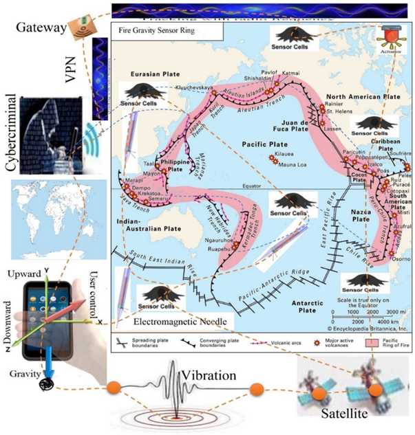
|
Figure 36 Fire Gravity Sensor Ring (Rushe and Heaton (2023). |
The Bermuda Triangle is a mysterious area, a crime zone created by cybercriminals with gravity sensors. This airspace is surrounded by sensor barricades and all vehicles are digitally hijacked. Ships, aircraft, submarines, launches, steamers and helicopters are instantly digitally stolen by gravity sensors and satellite tracking. The stolen vehicle is later destroyed by a sudden explosion on sensor tracking. It is a triangular archipelago, the boundaries of which are not universally recognized, but which instills fear in all before entering the region. Hence it is known as Terrible Zone. So far, more than 50 ships and 20 planes have mysteriously disappeared in the region Rushe and Heaton (2023). Research shows that cybercriminals have digitally hijacked these lost vehicles by tracking them to gravity sensors. Such mysterious zones can be created anywhere in the world at any moment through wireless sensor technology.
Pacific Ring of Fire is a seismic zone Britannica. (2023). Cybercriminals have used satellite technology to create a death trap called the Pacific Ring of Fire, also called as Fire Gravity Sensor Ring. The Ring of Fire consists of volcanic arcs and oceanic trenches that partially surround the Pacific Basin USGS. (2023). In this Ring of Fire region, cybercriminals frequently use satellite technology to trigger earthquakes, man- made disasters, and volcanic eruptions, as shown in Figure 36. Research shows that some people think these disasters are natural, but they are man-made. Cybercriminals control this ring of fire using advanced satellite technology to create sudden artificial earthquakes and tsunamis to destroy people, planes and ships or carry out digital hijacking.
4.7. Struggling life
Global man-made earthquakes are environmental hazards, and have abnormally increased the rate and severity of disasters Palinkas et al. (2020). These artificial earthquakes are causing extreme and rare weather events in certain areas, resulting in wildfires, hurricanes, droughts, flash floods, landslides, loss of vegetation and wildlife, and increased heatwaves, more details at this video: https://www.youtube.com/watch?v=q5nf6Wl5TVI. These earthquake-prone areas have permanently altered environments that can be uninhabitable for humans and biodiversity. The mental health effects of unexpected earthquakes on the growing population can be severe, deadly and devastating Dyregrov et al. (2018). By tracking wireless sensors in disaster areas, cybercriminals can spread CASSID diseases, especially covid-19, cardiac arrest Miah et al. (2023d), stroke, tracheal disorder, ARDS, chronic kidney disease, stomach cancer, liver cirrhosis, diarrhea, dengue, diabetes, fever, common cough cold, pneumonia, acute lymphoblastic leukemia and oral cancer. On the other hand, the reservoir is slowly compressed by gravity sensor tracking during artificial earthquakes and the bedrock is treated as a massless medium. Regular tracking with high radiofrequency devices causes the reservoir to dry up completely, causing dam failure to cause economic loss Miah et al. (2023); Miah et al. (2023c); Miah et al. (2023d); Miah et al. (2023e), environmental damage (Miah et al. (2018); Miah et al. (2022c); Miah et al. (2022e); Miah et al. (2022f); Miah et al. (2021f); Miah et al. (2021h)) loss of cultural resources or even loss of life (Hariri-Ardebili et al. (2013)). Moreover, the perspective of peace on earth, artificial earthquakes, pre-planned technological tsunamis, sensor volcano eruptions and man-made typhoons have positive effects despite the unexpected destruction, helping to regenerate water and land Miah et al. (2023h); Miah et al. (2023i); Miah et al. (2019); Miah et al. (2018); Miah (2013). What we need to do is create a model of peace for the present and future generations that will continue to coexist peacefully with the people living on earth, the dynamic technology and the magnificent beauty of nature, as long as there is blood in the struggling life.
4.8. Top Ten Tactics for Spotting Earthquake Terrorists
Security officials are using advanced magneto-optogenetics technology to detect earthquake terrorists through eyes or bio-cameras and voice detection. Security officers must wear personal area network control units and anti-radiation sunglasses when apprehending earthquake terrorists. Security officers follow the top ten rules, namely:
1) Using wireless sensors to encode personal recognition images by scanning the invisible flashes of open eyes of earthquake terrorists and identifying them by coordinating retinal scanning with them.
2) Police releases earthquake terrorists in the open through voice coding to track their GPS location to identify them.
3) Earthquake terrorists can be identified through location tracking by detecting switched-on electronic devices.
4) Amygdala coding of earthquake terrorists can be used to detect their crimes by analyzing daily audio-video report.
5) Retina visible distance of earthquake terrorists detectable by GPS and real time.
6) Pre-reports and post-reports of land surface movements of earthquake terrorists can be identified through satellite image analysis.
7) Contact and social networks of earthquake terrorists can be traced to their location.
8) Earthquake terrorists can be identified by fingerprinting their body movements and hands activities.
9) Atmospheric digital traps can be placed at a specific GPS location to detect five-sense sensors on the body of earthquake terrorists.
10) Earthquake terrorists can be identified by searching with the Aspiratory Ion Mobility Spectrometry (AIMS) and Digital Criminal Investigation Department (DCID) in four directions (North-East-West-South-Air-Land: NEWSAL).
Cybercriminals use DCID, which is an alternative system for investigation that uses wireless sensor technology to track, search, or monitor a suspect's retina and voice at a specific GPS location. A suspect is recognized at a specific GPS location with an RFID device through retinal scanning and voice coding. For this reason, the person is monitored 24 hours a day with the help of his eyes, speech, assistant sensors and electronic devices. In this manner, what is the suspect doing in 24 hours? what is he eating What is he saying? What is he thinking? What is he looking at? Where is he located? where is he sleeping? Who is he meeting? Is he involved in any terrorist activities? These answers will be monitored by cybercriminals. Moreover, the person's banking transactions, wireless communications and information exchange on social media etc. are also monitored and recorded. Also, cybercriminals can (1) hypnotize the person and control his movements, (2) make him suddenly ill with various CASSID diseases, (3) freeze his face in time through sensor tracking, (4) his eyesight can destroy, (5) shrink his skin structure or suffer from various skin diseases, (6) trap him in various digital traps in water, land and sky, (7) reduce his hearing or suffer from hearing diseases, (8) His decision-making powers are restricted and cybercriminals will send text messages from their smart mobile phones, he says so, (9) He is kept asleep or awake for long periods of time, (10) When he is traveled by a car, bus, boat , steamer, submarine or plane, cybercriminals may kill him in sensor accidents. So, to ensure a safe life for all, (a) no more fingerprints, (b) no more voice coding, (c) no more retina scanning, (d) no more long stay at a specific GPS location, (5) no more always switch-on sensor devices and electronic equipment except PANCU (Personal Area Network Control Unit).
4.9. Children Effect in Earthquake
The recent man-made earthquake is a devastating earthquake that puts women, men and children in dire straits. Thousands of children and families are at risk due to sudden earthquakes, more details from this video of Al Jazeera Report: https://www.youtube.com/watch?v=wfP6oaeXctg. Children's mental health deteriorates due to fear of earthquakes - memory loss, loss of appetite, inattention to studies, insomnia, restlessness, and fear of the invisible prevails in their minds. Children with disabilities are very vulnerable to earthquakes. During the earthquake, cybercriminals tracked wireless sensors to sexually harass girls and many of them were raped at various locations. To make small children helpless during earthquakes, their parents are tracked by cybercriminals and face various diseases, especially covid-19, cardiac arrest Miah et al. (2023d), diabetes, stroke, cancer, liver cirrhosis, acute respiratory distress syndrome (ARDS), dengue, chronic kidney disease, Respiratory disorders, fever and painful diseases. When their parents are re-tracked by cybercriminals with sensor devices, their parents fall ill and died in digital trap instantly, then these orphaned children are involved in various wrongdoings. Cybercriminals track children in earthquake-prone areas as they walk along riverbanks or ponds and drop them into water, re-track when they drown, paralyze the child's arms and legs, and finally apply gravity to the child through wireless sensor tracking. As a result, the affected child died instantly underwater. Again, cybercriminals track children on rooftops, trees, hills and high places, throw them to the ground and get sick and die instantly. Hundreds of children buried in the rubble and many missing in the earthquake - it's heartbreaking. Cybercriminals create earthquakes in residential areas while children and families are sleeping at home. After man-made earthquakes, sudden heavy blizzards, freezing rains, storms, total blackouts, load-shedding and disconnection of all communication systems, the calamity of the disaster came down in the area. Earthquake terrorists thus make the area more dangerous and the aftershock puts children at grave risk and complicates the wider humanitarian response. The recent earthquakes have damaged or destroyed residential building, schools, colleges, hospitals, religious institutions, roads & highway and other food, medical and educational facilities, which will further affect children. Governments, UNICEF and other organizations are assessing the impact of the earthquake and coordinating with partners to support the humanitarian response and mitigation measures. The study shows that the immediate priority is to quickly ensure that affected children and families receive much-needed assistance, otherwise the world's children will face one of the direst humanitarian situations in earthquake prone areas.
Cybercriminals in earthquake-prone areas infect children with Kawasaki disease by tracking wireless sensors to their eyes Reza et al. (2023). Again, due to wireless sensor tracking distributed from cloud network GPS location by cybercriminals, the prevalence of this disease increases and the disease spreads nationally, regionally and internationally in pandemic form.
4.10. Women Effect in Earthquake
Women in earthquake prone areas are severely affected. This effect resulted in many women becoming ill and subsequently dying from sensor tracking. Pregnant women are tracked down and killed by cybercriminals just after they give birth in earthquake-prone areas. Again, tracking female doctors before or after artificial earthquakes - some get sick and retracks and kills the sick Miah et al. (2022a). Tracking women in earthquake areas, sudden abdominal pain, stillbirth baby missing, obesity, calf muscle pain, back pain, neck pain and hair loss. Besides, miscarriage, difficulty getting up suddenly after sitting in a specific GPS location, digital itch, uterine cancer, breast cancer, colorectal cancer, etc. have drastically increased prevalence of 385 CASSID diseases due to wireless sensor tracking at a particular GPS location.
4.11. Challenging Infodemics
Advanced satellite technology is expanding so much that cybercriminals are misusing it to cause earthquakes and other disasters in specific locations. As the police and administration do not understand this misuse of technology, cybercriminals are evading higher authorities, tracking one by one, killing people and animals with sensor diseases, misusing technology to cause earthquakes, tsunamis, flash floods and landslides and spreading misinformation on social media. It is a difficult challenge to overcome Miah et al. (2022). That being said, the satellite technology currently in use is very good, which is a boon for human welfare. But some cybercriminals are misusing it indiscriminately and harming people, animals and things. This abuse is increasing at a geometric rate worldwide, which is worrying for everyone. So, policy-makers, geospatial experts, scientists, researchers must be informed about the power of decision-making through messaging, voice, video, audio, artificial intelligence to prevent its misuse, bring cybercriminals to justice. Otherwise, it is extremely challenging security everywhere for present and future generations.
4.12. Effect of CASSID
CASSID stands for Common Acute Sudden Sensorineural Infection and Disorder. The CASSID produces disease due to tracking towards individuals with advanced wireless sensor technology at a particular GPS location, for example- COVID-19, Cardiac arrest Miah et al. (2023d), acute respiratory distress syndrome Miah et al. (2022b), Stroke, Diabetes Miah et al. (2021e), Miah et al. (2020a)), Ophthalmic diseases Reza et al. (2023), chronic kidney disease (CKD), dengue (Miah et al. (2023g)), Stomach Cancer (Miah et al. (2023f)), digital dermal disease (Miah et al. (2023b)), numbness (Miah et al. (2021g)) and heatwaves (Miah et al. (2022f)) etc. The Covid-19 pandemic was considered a 'catastrophe' as well as post-traumatic stress disorder (PTSD) being worrisome (Kawashima et al. (2023)), which is spreading across the globe due to misuse of advanced wireless sensor technology (Miah et al. (2023)), (Miah (2023a)), (Miah et al. (2022)), (Miah et al. (2022a)), (Miah et al. (2021)), (Miah et al. (2021a)), (Miah et al. (2021b)), (Miah et al. (2021c)), (Miah et al. (2021d)) & Miah et al. (2020).
Research shows that by tracking the heart with a wireless sensor device, cardiac arrest can be detected in any human or animal at a specific GPS location. From the cloud network, cybercriminals track the heart of a particular person with the help of a wireless sensor device, causing the person to instantly suffer cardiac arrest. When the cybercriminals re-tracked the person's heart, blood flow to the aorta was cut off and he became fatally ill. This tracking switch is 'on' on the mobile phone of the cybercriminals and controls the high radio frequency through the cloud network. Cybercriminals track down the person's aorta and instantly die of cardiac arrest. Cybercriminals can track a person's heart by following their retinas, speech and active mobile phones during artificial earthquakes and cause instant digital death. Studies have shown that presidents, prime ministers, ministers, CEOs, politicians, businessmen, religious leaders, bankers, heads of institutions, rich people, industrialists, judges, researchers, scientists and other famous people are being tracked and killed by cybercriminals. It is to be noted that on 14th August 2023, cybercriminals conducted cardiac arrest by tracking Allama Delwar Hossain Saidi. After some time, the cybercriminals tracked him down again and cyber killers killed him digitally. This death is not normal, which is known through research as below-
The study shows the blood circulation speed fluctuates with infection due to misuse of prevaricated radio frequency within GPS locations due to active open-eyes, self-voice, over excess weight and nearby cellular phone. The findings reflect the significance in cardiac arrest through effective prevention and medication that the physicians provide Miah et al. (2023d).
and
The study also revealed that human and animal can be killed instantly even by digital sudden suffocation and airway closure at fixed GPS location on Earth by tracking wireless sensors Miah et al. (2022b).
Figure 37
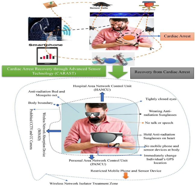
|
Figure 37 Cardiac Arrest Recovery through Advanced Sensor Technology (CARAST) |
Other famous people who died of man-made cardiac arrest include Mother Teresa (September 5, 1997), Safia Islam Sunamganji (May 6, 2019), Fabrice Muamba (March 17, 2012), Jordan Brister (January 8, 2023).), Pierre Nkurunziza (June 9, 2020), Dr. A.P.J. Abdul Kalam (July 27, 2015), Mohammad Mursi (June 17, 2019), DIG Md Sohrab Hussain (May 12, 2018), Chandan Ram Das (April 26, 2023), Tapas Pal (February 18, 2020), John Ritter (September 11, 2003), Christopher Reeve (October 9, 2004), Brittany Murphy (December 20, 2009), Singer Ayub Bachchu (October 18, 2018), and Michael Jackson (June 25, 2009). The recovery system shows in Figure 37.
These digital killers are spreading lies on social media that the patient's death is normal. When the relatives of the deceased protested and sought justice. Three cybercriminals Md Hatem Ali, Md Jashim Uddin and Md Nizamuddin biased the administration by tracking, and arresting many protesters by the police. Before Saidi's death, cybercriminals had created artificial earthquakes of magnitude 5.5 in various areas to create fear among people Mahmud (2023). Cybercriminals are committing numerous cybercrimes from the underworld, especially artificial earthquakes, sensor pandemics, vehicle accidents, flash floods, tsunamis, landslides, sinking steamers, instigating wars between two countries, shutting down gas pipelines, and stealing bank currency digitally. Again, cybercriminals use technology to win ineligible candidates in national elections on some illegal terms with political parties—which misuse wireless sensor technology to obstruct fair elections.
4.13. Earthquakes like Pandemics
An artificial earthquake is a violent and sudden shaking of the ground caused by the movement of tectonic plates along a fault line in the Earth's crust, produced by tracking satellite technology. Man-made earthquakes through technology are affected by the sudden generated vibration towards people, animals and objects on the ground and in the underground, as well as soil liquefaction, landslides, cracks, ground deformation, soil subsidence, avalanches, man-made pandemics and famines, fires, wildfires, deforestation, desertification, volcanic eruptions and tsunamis, resulting in extensive property damage and loss of life, more details from the video of WSJ: https://www.youtube.com/watch?v=Hd4xCmuwiBw. Moreover, a disaster is an unexpected accident such as an earthquake or plane crash or train accident especially where a large number of people are injured or killed due to misuse of wireless sensor technology. Similarly, the coronavirus is a pandemic caused by the misuse of sensor technology in certain GPS location, causing many people to fall ill and many to die. So, it can be said that in both disasters’ life safety is uncertain but accidents Silva et al. (2021) are certain with short term, medium term and long-term effects. Moreover, Health- related hazards, vulnerabilities, exposures, misuse of technology, and impacts of artificial earthquakes are alarmingly increasing worldwide Van et al. (2022).
4.14. Myth About Earthquake
It is difficult to say where the myth about the earthquake will end. Earthquakes are increasing day by day, which is not natural but artificial, it is like a myth, everyone is interested to know. The study finds these earthquakes similar to misuse of advanced technology by cybercriminals. Advanced technology has accelerated human well-being, but lack of dynamic security has taken away the passion of technology from human society. However, thanks to this, the entire world is at hand today. With the proper use of advanced technology, people are rising to the golden peak of progress from world to universe. On the other hand, by misusing that technology, a group of cybercriminals are betraying the world by creating artificial earthquakes, damaging valuable resources and killing millions of lives. These cybercriminals are lying to the general public about artificial earthquakes and using sensor technology to spread lies on social media. Research shows that cybercriminals are misusing this technology to create artificial earthquakes on any of the Earth's tectonic plates to cause severe damage, while blaming nature for the disaster. Again, cybercriminals are saying in the media that Japan is the epicenter of the earthquake. Research shows that satellite tracking can create artificial earthquakes in any tectonic area on Earth. Therefore, not only Japan, but any country in the world can become an earthquake-prone country by cybercriminals. Many people think that all earthquakes in the world are natural - this is also wrong. Because the most frequent earthquakes in the world are man-made earthquakes, for example, from last January 2023 to March 2023 there were a total of 79 earthquakes in the world - all of them were man-made earthquakes. Thus, myths about earthquakes still exist among people. These myths are not scientific. Myths about artificial earthquakes on Earth will be unmasked - but that day is not far off. Research shows that humans will mitigate artificial earthquakes with safe technology, that earthquake terrorists will be prosecuted in high courts Miah et al. (2023); Miah et al. (2023h); Miah et al. (2022); Miah et al., 2022a), that an earthquake-free world will be peaceful - this is universal truth.
4.15. Religious Perspectives on Earthquake
Earthquake is a manifestation of Almighty God's infinite power. Because of disobedience He has completely destroyed many nations in the past by earthquakes. On the day when the life of the universe will run out, Allah Ta'ala will destroy the entire creation through a terrible earthquake. Almighty Allah warns people through His various signs, remind them of the consequences of disobedience and urge them to return to the righteous path. Allah Ta'ala says, "I send signs to warn." (Surah Bani Isra, 17:59). Earthquake is one such sign. Allah also says, 'Say, Allah is able to send punishment from above you or from under your feet' (Surah An'am, 6:65). In the past, Allah Ta'ala has completely destroyed some nations through earthquakes as a punishment for disobedience. Salih's tribe of Thamud, Shuaib's tribe of Mayyan and Lut's tribe of Lut were destroyed by earthquake. Allah Ta'ala said, 'I buried some of them under the ground.' (Surah Ankabut, 29:40). However, due to the special supplications of the Holy Prophet (PBUH), Allah Ta'ala has promised not to destroy His Ummah completely.
Due to the limitations of advanced satellite technical knowledge, some Muslim leaders may disagree about the source of the earthquake, because- “The creation of the heavens and the earth is certainly greater than the re-creation of humankind, but most people do not know” (Surah Mu’min, Verse 57). When there is a sudden earthquake somewhere in the world, most of the people think that it is a miracle of nature or Allah’s (God's) punishment. But the study shows that cybercriminals created man-made earthquakes across the earth due to misuse of satellite technology. In this disaster, many people lost everything and became depressed, broke down, maybe many people got sick. Research shows that sudden earthquakes are man-made satellite tremors. Earthquake criminals at specific GPS locations cause tremors through satellite cloud networks, causing damage to humans and animals and populated areas. Allah says- “Have they not travelled throughout the land to see what was the end of those who were ˹destroyed˺ before them? They were far superior in might and ˹richer in˺ monuments throughout the land, but their ˹worldly˺ gains were of no benefit to them (Surah Mu’min, Verse 82)”.
The Dead Sea is one of the most unique places on earth with its high mineral and salt content. The Dead Sea is an important historical site, an endorheic lake located in the Jordan Rift Valley. Its left lateral-moving transform fault is located along the tectonic plate boundary between the African plate and the Arabian plate and runs between the eastern Anatolian fault zone in Turkey and the northern edge of the Red Sea rift in southern Sinai. Moreover, the Dead Sea is the site of the ancient city of Sodom, the home of Prophet Lut (A.S.), who preached the word of Allah (God) endlessly, but to no avail, because his wife was an unbeliever in her own family. During the time of Prophet Lut (A.S.), at the behest of Allah, the angel Gabriel used invisible energy (radio frequency) to overturn and destroy the cities (Jordan River), later known as the Dead Sea. At sunrise, with the help of waves, there was a loud noise via radio frequency at a specific GPS location before the angel destroyed the area. Focusing on the source of the sound, the angel overturns the designated area with the sound (wave), destroying everything in the area - a historical witness for all to this day, so that people receive proper education and awareness. Allah says, “Then at sunrise they were seized by a loud sound. I turned the town upside down. And I showered upon them a heavy shower of pebbles. Surely in it there is guidance for a thinking nation” (Surah Hijr, 15:73-75).
ISNAPHO tests show that earthquakes can be triggered anywhere in the world, at any time, at a GPS location determined by satellite technology. A class of humanoid earthquake terrorists create these artificial earthquakes by abusing advanced technology. Many countries of the world have been causing a lot of damage by creating artificial earthquakes for a long time, which are invisible to the common people. Again, earthquake criminals spread false news on social media that it is the punishment of the creator. But the creator did not inflict severe punishment by killing people and animals and destroying settlements by causing so many earthquakes in the world. Because, Allah says - " I am not oppressor to slaves " (Surah Qaaf, Verse 29). Again, the Prophet (PBUH) prayed to Allah for the protection of his Ummah - "May the harsh punishment that was inflicted on the Ummah of the previous Prophet-Messenger, not be inflicted on his Ummah". Send the last and greatest Prophet and Messenger, Hazrat Muhammad (pbuh) to the earth for the ultimate perfection of mankind. Lord, he is sent for world peace, for the welfare of world humanity. Allah says, "We have sent you ˹O Prophet˺ only as a mercy for the whole world" (Surah Ambiya, Verse 107). Allah also says - We have sent you ˹O Prophet˺ only as a deliverer of good news and a warner to all of humanity, but most people do not know.' (Surah Saba, Verse 28). The Prophet (PBUH) was sent as a guide for all mankind. In the hadith narrated from Hazrat Abdullah Ibn Amr Ibn As (RA) in the Faith chapter of Sahih Muslim Sharif, it is in Qudsi: O Allah! Do not completely destroy my Ummah for the sake of other Ummahs. Allah has accepted this prayer. Man-made disasters have spread on land and water. Allah wants them to taste the punishment of their deeds, so that they return (Surah AR-Rum, 30:41). The calamities that befall you are the result of your deeds and He forgives many of your sins (Surah Ash-Shura, Verse 30). Cybercriminals are killing people of different religions by creating earthquakes in different countries of the world with advanced technology. But killing people and creating terror is against any religion, ideology and civilization. Allah (God) said- “And whoever kills a believer intentionally, their reward will be Hell—where they will stay indefinitely. Allah will be displeased with them, condemn them, and will prepare for them a tremendous punishment” (Surah An-Nisa, Verse 93). Allah’s Messenger (ﷺ) said “I begged my Lord that my Ummah should not be destroyed by drowning (by deluge) and He granted me this” Sahih Muslim (n.d.). So, the wrongdoer activities are responsible of cybercriminals, Allah says- Whoever does good, it is to their own benefit. And whoever does evil, it is to their own loss. Your Lord is never unjust to ˹His˺ creation Surah Hamim Sajda, Verse 46. So, Earthquakes around the world today are not natural but man-made due to advanced satellite tracking technology.
4.16. Digital Theft in Earthquake prone Areas
Cybercriminals are not only responsible for earthquakes, but have also been convicted of massive thefts in the area. Looting incidents by cybercriminals have increased in various cities after the devastating earthquake caused massive damage and loss of life. Cybercriminals stole goods and furniture from buildings and shops that collapsed in the earthquake. This theft occurs because many residents and owners of collapsed buildings or shops are unable to move their belongings to a safe place in time Kucukgocmen (2023). For example, people affected by the earthquake in Antakya, the capital of Hatay province in Turkey, were seen removing goods from shops and houses, more details from the video of Gurdian News: https://www.youtube.com/watch?v=6qkNwj5-uzg. They are taking this measure as goods have been looted from many shops and houses in that city. Cybercriminals have looted homes, shops and collapsed houses in the last February 6, 2023, the worst earthquake in memory hit neighboring Türkiye and Syria International Desk. (2023). Many people displaced by the earthquake are spending days inside their cars or in tents. As no one was home, various valuables including gold were stolen from their house International Desk. (2023). Research shows that cyberhackers are the main earthquake criminals. As the front was secured, the robbers entered the store from the back. Cybercriminals rob supermarkets, pharmacies, jewelry, shoe stores, and a variety of businesses. Cybercriminals use special types of mobile networks to create artificial lightning strikes while stealing. The administration is aware of this and the police are determined to crack down on looters in earthquake-prone areas. A state of emergency has been declared in earthquake-hit areas besides extending the term of punishment for the looters. About 60 people have been arrested for looting in Turkey's earthquake-hit areas TASS. (2023).
4.17. Mysterious Sense in Technology
The impact of the sense of technology on the human body is a wonder in the world. Although the use of advanced wireless sensor technology is unprecedented, many are concerned about its sudden effects on the human body. It should be noted that due to lack of proper security, misuse of this technology is increasing day by day at an alarming rate. Note that what people are saying, what they are imagining, what they are seeing—these things are being transferred to another server in an invisible connection with audio-video records. Not only this, human/animal body tracking with this sensor technology produces sound or flatus and instant shivering and fever. Again, tracking the tectonic plates with this sensor technology causes loud cracks and high radiofrequency induced artificial earthquakes at fault locations, more details regarding issues from the video of CNBC: https://www.youtube.com/watch?v=qjAy68PR87Q. With the help of this technology, various stimuli are created in the human body. When people talk in a certain environment, their GPS location is instantly detected. Magnetoreceptor and photoreceptors allow conversation, communication or information exchange between two or more people and animals without a mobile phone connection. Even what a person decides or gives can be changed and controlled through this technology. Through the sensor technology, CASSID tracks the spread of disease in human/animal body, especially the spread of diseases such as Covid-19, Monkeypox, Cardiac arrest Miah et al. (2023d), CKD, Liver cirrhosis, Stroke, Respiratory disorders, Skin diseases, Cancer, Diabetes, ARDS, Paralysis and Tumors. On the other hand, earthquakes, landslides, tsunamis, volcanic eruptions and land ruptures are tracked on the surface using this sensor technology. If you track trees, buildings, and standing objects, they instantly fall, burn, swell, and shrink. This sensor technology is so dangerous that it tracks in the atmosphere causing extreme heat/heat flux, extreme cold, cyclones and tornadoes. With this technology, sudden flash floods are triggered when clouds are tracked through satellite technology. Buses plying on highways, planes and helicopters flying in the open air can be tracked by wireless sensors and turn into dangerous accidents in no time. Tracking this sensor technology leads to electrical load shedding, gas and fuel shortages. This sensor technology controls the atmospheric pressure, temperature and humidity on Earth to the detriment of human society. Because of the tracking, this technology not only creates artificial earthquakes, but also creates or destroys many things at a given GPS location—proving that the impact of technology's senses on the human body, whether a blessing or a curse, is too close to reckon.
4.18. Risks of Global Economic Earthquakes
Earthquakes can occur in any location at any time USGS. (2023). Earthquake is becoming so terrible day by day that it is causing serious damage to many lives and property, more details regarding earthquake from the video of CBC News: https://www.youtube.com/watch?v=Zxbhh-njA5A. Earthquakes cost hundreds of billions of dollars, but there is still no proper way to mitigate them. The study shows that the total number of deaths from earthquakes worldwide from 2001 to 2023 (through February) was 745,773 and an average of 32,425 per year. Moreover, annual long-term damage caused by earthquakes in the United States alone is estimated at $14.7 billion per year, and this number appears to be increasing rapidly Turner (2023). The spatial significance of risk on man-made earthquake is expressed as economic risk when risk probability is combined with vulnerability. Accelerating the process of decarbonizing the global economy to reduce the number of human deaths from artificial earthquakes requires strong action at the public, corporate, and private levels in developing safe technologies Rissman et al. (2020).
4.19. Policy Implication
Humans, animals, plants, soil, air and objects around the world are in danger due to misuse of satellite technology. The threat of earthquakes by digital criminals in every country, the risk of an artificial climate crisis ignited by sudden digital heatwaves, the public survival made difficult by technological floods, the terrible pandemic of environmental diseases in wireless tracking, the disconnection of neighboring countries and the severe recession of the national, regional and global economy Aulady and Fujimi (2019)- all these are seismic criminal operations. Hence, governments and policy makers can formulate and implement effective law and policy actions to mitigate man-made earthquakes and prosecute earthquake criminals. To increase public awareness in the media about the use and misuse of satellite technology in daily life, so that the administration can take swift action against earthquake criminals involved in its misuse. The study shows that outcome-based goals relate to the impact of appropriate mitigation interactions on reducing potential consequences of man-made earthquakes and outcomes across systems of interest Abrams et al. (2002).
The study reveals that mobile companies can define user-safe health outcomes in terms of wireless network coverage risk. Similarly, national or global insurance companies define acceptable consequences in terms of financial risk, road-water-air transport networks define acceptable consequences in terms of their impact on national economic flows, and national/local governments, including owners of large building stock and residential areas, may define acceptable consequences of business disruption or land property destruction. Thus, different levels of perspective can determine safe technically acceptable outcomes for man-made earthquake mitigation according to the policy implications.
4.20. Mitigation
There exists much work on disaster mitigation and management around the world (Tran and Saito (2016); Solmaz and Turgut (2017); Erdelj et al. (2017). Artificial earthquake mitigation and management is an extremely important area of research because earthquake resistance on Earth is largely beyond human control. Although only a few countries in the world have earthquake warning systems, which use science and technology for monitoring systems to warn machines and people. However, these systems cannot completely prevent artificial earthquakes. Moreover, it is possible for only seconds to minutes to control and alert sensor networks used in artificial earthquakes to take appropriate action for mitigation.
Studies show that every US$1 spent on earthquake mitigation saves $10 during a disaster strike Wyss (2017). The study proposes effective solutions for national policy on man-made earthquake mitigation based on advanced science and technology. Earthquake mitigation is possible by ensuring safe advanced satellite technology as part of policy-making and legislation to control tectonic plates in countries around the world through network gateway isolation. This gateway isolated satellite signal actually ensures technological security in residential areas, strengthening communication systems, safe cultivation of agricultural land and sustainable biodiversity conservation in forest areas just before the onset of earthquakes.
For artificial earthquake mitigation and management, seven types of sensors are employed Rahman et al. (2016), namely: (1) human sensors, (2) animal sensors, (3) plant sensors, (4) water sensors, (5) radon sensors, (6) Atmospheric Air sensor, and (7) advanced wireless sensors. Animal sensors are placed on the body of animals to measure their body temperature and detect their behavior. It is assumed that an animal sensor becomes active when an animal's current body temperature is lower or higher than normal body temperature, otherwise, the sensor mode is in sleep state. Water pressure sensors are placed in underground wells and water channels and in various places underground where the flow of groundwater is constant. It is assumed that a water pressure sensor becomes active when it detects that the current water pressure exceeds its threshold limit, otherwise, it remains in sleeping mode. Radon sensors are placed in rock, soil, and groundwater to detect radon emissions. It is assumed that a radon sensor becomes active if it detects radon emissions while in sleeping mode Zafar and Afzaal (2017). In this way, other object can deploy sensor and detect to alarm the cause of earthquake from its behavior.
The study Illustrates the mitigation model of man-made earthquake with diverse tools of EMMAST Figure 38. The EMMAST implies Earthquake Mitigation and Management through Advanced Satellite Technology. The study proposes those who implement public awareness and mitigation measures following this research will be successful, otherwise they will face repeated man-made disasters and suffer severe losses. In many countries of the world, secure communication and infrastructure facilities are being increased along with advanced satellite technology to deal with such emergent situations. It is hoped that this research will make disaster mitigation systems safer and more efficient, saving millions of lives. This is highly motivated pioneer study about earthquake with world-class scientific research through advanced satellite technology. This research on earthquake is unique, which will open many research doors for rationalized generations.
Figure 38
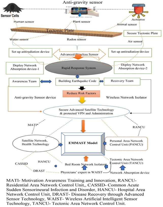
|
Figure 38 Earthquake Mitigation and Management Through Advanced Satellite Technology (EMMAST) Model. |
By adopting the earthquake risk reduction program for earthquake mitigation, the concerned parties should be proactive in bringing its harmful effects to a bearable level and quickly meeting the overall damage. Conducting subsequent recovery and rehabilitation programs in earthquake-prone areas more efficiently and ensuring alternative information-technology and communication systems, more details alternative facility from the video of TRT World: https://www.youtube.com/watch?v=c_ir_Dnv5Q8. National and international development agencies and wealthy individuals need to come forward to provide urgent humanitarian assistance to the distressed population. It would be great to form an Intensive Monitoring Team to coordinate, target and strengthen the activities of concerned government, development agencies and non-governmental organizations in coordinated task forces to address basic needs in earthquake- affected areas. Although humans are the main drivers of misuse of technology and creation of artificial earthquakes at specific GPS locations, ensuring proper human leadership and use of safe technologies is an effective solution to earthquake mitigation. Research shows that it is possible for humans to mitigate all types of disasters, including earthquakes, through advanced technology. Humans are the best creatures in creation and they have created the best modern technology – ensuring fair and safe systems for all. To this end, each Member State will establish a Rapid Action Team for Earthquake Mitigation and Management (RATEMM) under the leadership of the United Nations including Intergovernmental Panel on Climate Change (IPCC), Seismology and Earthquake Engineering Research Infrastructure Alliance for Europe (SERA), United Nations Environmental Programme (UNEP), International Seismological Centre (ISC), National Earthquake Information Center (NEIC), Disaster Prevention Research Institute (DPRI) of Kyoto University, Kandili Observatory and Earthquake Research Institute in Turkey and World Meteorological Organization (WMO). The RATEMM team will be operated in cooperation with the United States Geological Survey (USGS) and under the supervision of INTERPOL. The sooner secure wireless technology is made available to everyone and climate criminals are brought to justice with the help of RATEMM, the sooner there will be no barriers through alternative policy actions Porter & Rossini (1987) to building a peaceful earthquake-free world.
4.21. Digital Exponential Revolutionary
Advanced sensor technology enables a new future in the world with effective protection of digitalization for social welfare and inclusion ECLAC (2022). Digital exponentially revolutionized sensor technology, putting everything within human reach and accelerating instant communication. But due to the misuse of this technology by cybercriminals, the world is facing unexpected health pandemics Miah et al. (2023), environmental problems (Parisha et al. (2022)), climate crisis Miah et al. (2021f), data misinformation and digital corruption. Man-made earthquakes, flash floods (Miah et al. (2023h)) and the coronavirus pandemic (Miah et al. (2022)) due to misuse of wireless sensor technology have caused unprecedented economic, social and religious impacts around the world. Digital technologies have grown rapidly and their use among abusers in unsecured cloud networks has become a national, regional and global perspective Miah et al. (2022a). Human beings, animals, plants, land surfaces and other objects are being seriously harmed by the brutal digital abuse of cybercriminals. Acceleration of sensor technological progress in the digital field is using sensor devices and actuator applications via cloud networks, decision-making capability systems or artificial intelligence routines. The wireless sensor technological revolution has combined with a change in long-term strategy of climate criminals with the foremost organizational commitment to abuse advanced satellite technology to massively destroy the tracking role on global platforms, resulting in extreme earthquakes, heatwaves, wildfires, climate change, sudden desertification, deforestation at a specific GPS location and unexpected floods somewhere else (Miah et al. (2023h)). Ensuring the use of safe technologies, planning long-term strategies and active participation of stakeholders is crucial to protect against these harmful effects.
4.22. Universal Concern
Building a safe, risk-free and peaceful society is the common expectation of all the people of the world. Ignoring all obstacles and disasters with this hope, people struggle and move forward. If there are hundreds of blows, scornful countermeasures and advanced digital killer technology, still never stop moving towards the destination, which is not alarming to all. But our world is not what it was fifty years ago due to the misuse of wireless sensor technology. But technological crime challenges innovation and innovators due to lack of proper security. Climate criminals extrajudicially killed the inventor who through his research discovered advanced technology for human welfare. Climate criminals sought to increase climate terror on Earth by silencing scientific discoveries and humanity, but they failed. Because, another scientist has invented ISNAPHO, which will act as a deadly missile against cybercriminals. Cybercriminals will be unmasked through this ISNAPHO and global climate will be peaceful through EMMAST. The study is specialized research, which is conducted through advanced satellite technology. When one reads or tries to study this research after it is published, the reader will face many obstacles, especially the one who tries to understand this research, cybercriminals will try to keep him busy in various ways, so that he does not study this research. Thoroughly on the other hand, policymakers and others read it, cybercriminals will track the reader's brain with false messages and create confusion. Then the wireless sensor tracks the reader and his family/relatives will be sick, especially fever, cold, cough, sneezing, sudden headache, dysentery, shortness of breath, irritated itching (Miah et al. (2023b)), dengue (Miah et al. (2023g)), diabetes (Miah et al. (2021e); Miah et al. (2020a), kidney disease, stomach disease (Miah et al. (2023f)), sudden body tremors, stroke, numbness (Miah et al. (2021g)), facial palsy, eye diseases (Reza et al. (2023)), cardiac arrest (Miah et al. (2023d)) , sudden heavy sleep, frequent urination, loose stools, loss of appetite, long sleepless nights, restlessness due to piercing the body with electromagnetic needles, sudden stress in the office. Cybercriminals track in the amygdala causing a sudden loss of decision-making ability (Miah et al. (2022a)). Many times, this research reader is surrounded by man-made storms, tornadoes, flash rains (Miah et al. (2023h)), heatwaves (Miah et al. (2022f)), extreme heat, electrical loadshedding, internet disconnections, download problems and lost urgent files are the misdeeds of cybercriminals. Sometimes cybercriminals track the wireless sensor and create a fight between the reader's wife or office colleagues. The study warns that if you read the research carefully, you will realize how dire the digital abuse of cybercriminals is. Again, cybercriminals will publicly humiliate this research reader by making him a fake corruptor in political corruption and jail-fine. On the other hand, cybercriminals track female readers with wireless sensors to suddenly increase sexual arousal, and cybercriminals misuse sensor technology to rape innocent women. And if someone wants to evaluate this research and give international awards to the researcher, still that person or institution may face the above problem. Moreover, if you are brave and tactful, you will win in all cases, otherwise you will have to be trapped in the web of conspiracy of cybercriminals for the rest of your life. This is a universal concern.
4.23. Future Direction
Once an earthquake occurs on a particular tectonic plate, the seismic coder detects it through seismic coding. Later earthquake criminals activate the same coding and earthquakes occur again on that plate - thus earthquake criminals create multiple earthquakes on the same tectonic plate. The EMMAST method should be followed to avoid future earthquakes on any tectonic plate. Therefore, for future safety, all types of seismic coding should be removed. The wireless sensor network control units and satellite gateway control units should be installed in each seismic area, and regular intensive monitoring should be carried out. As a result, whenever a tectonic plate vibrates, the EMMAST device absorbs it through electromagnetic waves, i.e., stops the vibrations. Thus, the plan to place mitigation devices on all the Earth's tectonic plates will free present and future earthquakes. Information from this innovative research will play an important role in future work on comprehensive earthquake mitigation and management (Di Giacomo and Storchak, (2023)). Cybercriminals are currently misusing satellite technology to create unimaginably artificial earthquakes. All in all, safer satellite technology is needed to control these unusual earthquakes. Otherwise, if these artificial earthquakes gradually become widespread, they will get out of control in the future, destroying many houses and causing death millions of lives.
4.24. Long Road Ahead
The best life in this world - we are all humans. We are all supportive and peaceful to each other. Gifting a peaceful world to present and future generations depend on the collective efforts of all of us. While the path forward for earthquake mitigation may be challenging and uncertain, sensor technology can only improve (Miah et al. (2022a)), disasters may become more intense (Miah et al. (2023h)), so none of us will sit by, or even fear them. Together we will be determined to build an earthquake-free world if we adopt a long-term plan to develop earthquake mitigation systems (Miah et al. (2021f)). But we are all confident in the possibilities of disaster mitigation and survival of the fittest - a long road ahead and if more disasters may come in the future, let us not forget the way forward - let us stand united. The day is not far when humans will research artificial earthquake mitigation and management through advanced control technology and save millions of lives.
5. Conclusion
The study illustrated the findings with man-made technological earthquake, landslide, sensor tsunami, building collapse, bridge breaking, river erosion etc.at a particular GPS location. The findings include the postulate regarding fluctuated satellite technology and climate crisis at a fixed GPS location. For each person, animal, object, environment, or climate of the existing area dies, damages, burns, oscillates or melts due to misuse of processed satellite technology with the fixed GPS locations and distributed satellite positions at a sensor real-time. Man-made disasters are not only the main obstacle to a peaceful society, but also the continuous advancement of safe technologies to reach the ultimate destination.
Data Availability
The data being used to support the findings of this research work are available from the corresponding author upon request.
Funding
This research work is a part of PhD Thesis, which was funded by the Zamalah Postgraduate Scholarship of UNIMAS, Malaysia and also sponsored by the Information and Communication Technology Division, Ministry of Posts, Telecommunications and Information Technology, Government of People’s Republic of Bangladesh. The funders had no role in the design of the research, in data collection, analyses or final interpretation of data, in the writings of the manuscript, or in the decision to publish the findings.
CONFLICT OF INTERESTS
None.
ACKNOWLEDGMENTS
The authors acknowledged the authority of Universiti of Malaysia Sarawak (UNIMAS), Malaysia for providing the Zamalah Postgraduate Scholarship for the completion of PhD degree. The authors are also grateful to the authority of the Information and Communication Technology Division, Ministry of Posts, Telecommunications and Information Technology, Government of People’s Republic of Bangladesh, for PhD Fellowship during the higher study in Malaysia. The authors acknowledged the UNIMAS Malaysia's Bantuan Police for providing security during the night as the ISNAPHO test was conducted at the lake. The authors acknowledged the authority of North East Medical College & Hospital (NEMCH), affiliated to Sylhet Medical University at Sylhet in Bangladesh for kind support. The authors also acknowledged the higher authority of International Conference on Innovation and Transformation for Development (ITD-2021) at Green University of Bangladesh, Dhaka, Bangladesh for oral presentation.
REFERENCES
Abrams, D. P., Elnashai, A. S. & Beavers, J. E. (2002). A New Engineering Paradigm : Consequence-based Engineering, working paper, Mid-America Earthquake Center, University of Illinois, Urbana-Champaign.
Al Jazeera. (2021, October21). No Country Will be Spared’ Impact of Climate Change : US Govt.
Aulady, M.F.N. & Fujimi, T. (2019). Policy Implication for Economic Losses Reduction due to Earthquake Disaster in Bantul City, Indonesia. IOP Conference Series: Material Science and Engineering, 462, 012051. https://doi.org/10.1088/1757-899x/4620/1/012051
Britannica. (2023). Ring of Fire. The Editors of Encyclopaedia, Encyclopedia Britannica, Invalid Date.
Di Giacomo, D. and Storchak, D.A. (2023). Digitization of BCIS Bulletins and the ISC Quest to Verify Pre- Digital Earthquakes. Comptes Rendus. Géoscience, 355, 23-34. https://doi.org/10.5802/crgeos.185
Doocy S, Daniels A, Packer C, Dick A, Kirsch TD. (2013). The Human Impact of Earthquakes : A Historical Review of Events 1980-2009 and Systematic Literature Review. PLoS Currents, Apr. https://doi.org/10.1371/currents.dis.67bd14fe457f1db0b5433a8ee20fb833
Dyregrov, A., Yule, W. & Olff M. (2018). Children and Natural Disasters, European Journal of Psychotraumatology, 9, Sup2, https://doi.org/10.1080/20008198.2018.1500823
ECLAC (2022). Digital Technologies for a New Future. Economic Commission for Latin America and the Caribbean (ECLAC), United Nations. 1-95.
Ellidokuz H, Ucku R, Aydin UY & Ellidokuz E. (2005). Risk Factors for Death and Injuries in Earthquake: Cross-Sectional Study from Afyon, Turkey. Croatian Medical Journal, 46(4), 613-8.
Erdelj, M., Król, M. & Natalizio, E. (2017). Wireless Sensor Networks and Multi-UAV Systems for Natural Disaster Management. Comput Netw, 124, 72–76.
Field, E. H., Dawson, T. E., Felzer, K. R., Frankel, A. D., Gupta, V., Jordan, T. H., ... & Wills, C. J. (2009). Uniform California Earthquake Rupture Forecast, Version 2 (UCERF 2). Bulletin of the Seismological Society of America, 99(4), 2053-2107.
Hariri-Ardebili, M.A., Mirzabozorg, H. & Kianoush, M.R. (2013).
Seismic Analysis of High Arch Dams Considering Contraction-Peripheral Joints
Coupled Effects. Central European Journal of Engineering, 3(3), 549–564. https://doi.org/10.2478/s13531-013-0111-z
Heaviside, O. (1889). On the
Electromagnetic Effects due to the Motion of Electrification Through a
Dielectric. Phil. Mag. 27, 324.
Hirosige, T. (1969). Origins of Lorentz’
Theory of Electrons and the Concept of the Electromagnetic Field. Hist. Stud.
Phys. Sci. 1, 151.
Hole, J. (2011). Rivers, Rifts and Ruptures. Nature Geoscience, 4, 428–429. https://doi.org/10.1038/ngeo1198
International Desk. (2023, February 13). Houses and shops
destroyed by the earthquake were looted. International News, ID-173546, Dhaka
Post, Dhaka, Bangladesh.
Kawashima, M., Murakami, M., Kobayashi, T., Takebayashi, Y.,
Tsubokura, M., Yasutaka, T. & Tamaki, T. (2023). Post-Traumatic
Growth Caused by the Great East Japan Earthquake and Response to Coronavirus
Disease 2019. International Journal of Disaster Risk Reduction, 95, 103917. https://doi.org/10.1016/j.ijdrr.2023.103917
Kucukgocmen, A. (2023, February 13). Antakya Businesses Empty their Shops to Avoid Looters. Middle East News, Reuters, UK.
Lorentz, H.A. (1892). La Th´eorie
´Electromagn´etique de Maxwell et son Application Aux Corps Mouvants, Arch.
Ne´erl. 25, 363.
Mahmud, I. (2023, August 16). Earthquake: Bangladesh Witnesses Highest Magnitude Tremor in 20yrs (Rewritten in English by Ashish Basu). The Prothom Alo (Daily News), Dhaka, Bangladesh.
Maxwell, J.C. (1865). A Dynamical Theory of the Electromagnetic Field. Philosophical Transactions of the Royal Society of London, 155, 459–512.
McCormmach, R. (1970). H. A. Lorentz and the Electromagnetic View of Nature. Isis, 61(4), 459–497.
Miah,
M. R. (2018). Assessment of Environmental Policy Instruments Along with
Information Systems for Biodiversity Conservation in Bangladesh (Doctoral
dissertation), PhD Thesis. IBEC, UNIMAS, Malaysia. 1-480.
Miah, M. R., Hasan, M. M., Parisa, J. T., Alam, M. S. E., Shahriar, C.
S., Akhtar, F., Begum, M., Sayok, A.K., Abdullah, F., Shamsuddin, M.A.S.,
Rahman, A.A.M.S., Alam, M.S., Tabassum, T., Chowdhury, S.H., Sharif, M.A.,
Rahman, M.S., Uddin, M.B., Tamim, M.A.K., Nazim, A.Y.M., Hannan, M.A., Uddin,
M.J., Uddin, MB., Ghani, M.A., Nipa, N.S., Khan, M.S., Ahmed, G., Hossain,
M.S., Rashid, M.M., Beg, M.O., Samdany, A.A., Hossain, S.A.M.I., Selim, M.A.,
Uddin, M.F., Nazrin, M.S., Azad, M.K.H., Malik, S.U.F., Hossain, M.K. &
Chowdhury, M.A.K. .(2022d). Impact of Oscillated Wireless Sensor
Networks to Initiate Cardiac Arrest. International Journal of Internal
Medicine, 11(1), 1-17. https://doi.org/10.5923/j.ijim.20221101.01
Miah, M. R., Hasan, M. M., Parisha, J. T., Huda,
M. B., Sher-E-Alam, M., Kiew Sayok, A., Rahman, M. S., Sharif, M. A., Uddin, M.
B., Chowdhury, S. H., & Bhuiyan, M. A. (2023h). Misuse of Advanced
Satellite Technology to Accelerate Man-made Flash Floods. International Journal
of Research -GRANTHAALAYAH, 11(3), 160–171.
https://doi.org/10.29121/granthaalayah.v11.i3.2023.5058
Miah, M. R., Hasan, M. M., Parisha, J. T.,
Chowdhury, S. H., Sayok, A. K., & Uddin, M. B. (2023). A Unique
Revolutionary Journey across the Globe to Discover the Novel Coronavirus.
International Journal of Research - GRANTHAALAYAH, 11(4), 84–100. https://doi.org/10.29121/granthaalayah.v11.i4.2023.5137
Miah, M.R. (2023a). Discovery of Coronavirus (book). Scientific and Academic Publishing, California, USA. 1-345 [in press]. url:
Miah, M.R., Chowdhury, S.H., Parisha, J.T., Rashid, M.M., Hassan, M.M. & Sayok, A.K. (2023b). Impact of Radiofrequency Tracking on Body Surfaces for Acute Exacerbations of Skin Disease. American Journal of Dermatology and Venereology, 12 (1), 1-9.
Miah, M.R., Hasan, M.M., Miah, M.M.U., Parisha,
J.T., Alam, M.S., Sayok, A.K., Rahman, M.S., Sharif, M.A. & Uddin, M.B. (2023c).
Innovative Policy to Enable Sustained Conserving of Forest Biodiversity.
International Journal of Agriculture and Forestry, 13(1), 1-22.
Miah, M.R., Hasan, M.M., Parisha, J.T. &
Sayok, A.K. (2023d). A Framework on Biodiversity Conservation Related
Policy Analysis. American Journal of Environmental Engineering, 13(1), 1-12.
Miah, M.R., Hasan, M.M., Parisha, J.T.,
Chowdhury, S.H. & Sayok, A.K. (2023e). Misuse of Technology to
Exacerbate Democracy in Crisis. American Journal of Sociological Research,
13(1), 12-23.
Miah, M.R., Uddin, M.M., Parisha, J.T., Shahriar, C.S., Alam, M.S., Chowdhury, S.H., Nazim, A.Y.M., Hannan, M.A., Uddin, M.J., Uddin, M.B., Nipa, N.S., Khan, M.S., Ahmed, G., Hossain, M.S., Rashid, M.M., Samdany, A.A., Hossain, S.A.M.I., Selim, M.A., Uddin, M.F., Nazrin, M.S., Azad, MKH., Malik, SUF., Hossain, M.M., Chowdhury, M.A.K., Tanjil, Y., Talukdar, MTH., Rahman, AAMS., Sayok, A.K., Sharif, M., A., Rahman, MS., Hasan, M.M., Alam, M.S., Uddin, M.B., Patowary, D., Bhuiyan, MRA. & Chowdhury, MTR. (2023f). Uncontrolled Advanced Wireless Sensor Technology to Enable Early Growth of Stomach Cancer. American Journal of Stem Cell Research, 5(1), 8-39.
Miah, M.R., Hasan, M.M., Parisha, J.T.,
Shahriar, C.S., Sayok, A.K., Selim, M.A. & Chowdhury, S.H. (2023g).
A Scientific Innovative Approach to Recovery from Dengue Fever. Public Health
Research, 13(1), 1-14.
Miah, M.R., Hasan, M.M., Hannan, M.A., Parisa, J.T., Uddin, M.J., Uddin, M.B., Rahman, A.A.M.S., Hossain, S.A.M.I., Sharif, M.A., Akhtar, F., Shamsuddin, M.A.S., Alam, M.S.E., Alam, M.S., Abdullah, F., Rahman, M.S., Uddin, M.Be., Shahriar, C.S., Sayok, A.K., Begum, M., Hossain, M.M., Khan, M.S., Ahmed, G., Malik, S.U.F., Samdany, A.A., Ghani, M.A., Hossain, M.S., Nazrin, M.S., Tamim, M.A.K., Selim, M.A., Talukdar, M.T.H., Chowdhury, F.T., Rashid, T.U., Nazim, A.Y.M., Rashid, M., Chowdhury, S.H. (2022). Myths about Coronavirus: A Research Defense. Global Journal of Health Science, 14(2), 63–112.
Miah, M.R., Hasan, M.M., Parisha, J.T. & Chowdhury, S.H. (2022a). Socioeconomic Impact of the Coronavirus Pandemic with Multiple Factors on Global Healthcare Policy. Journal of Politics and Law, 15(4), 242.
Miah, M.R., Hasan, M.M., Parisha, J.T., Shahriar, C.S., Sayok, A.K. & Chowdhury, S.H (2022b). Towards the Misuse of Advanced Wireless Sensor Technology to Enable the Sudden Onset of ARDS. American Journal of Medicine and Medical Sciences, 12(6), 616-638.
Miah, M.R., Alam, M.S., Hasan, M.M., Parisha, J.T., Sayok, A.K., Rahman, M.S., Sharif, M.A. & Uddin, M.B. (2022c). Scientific Environmental Governance to Accelerate Sustainable Biodiversity Management. Advances in Life Sciences, 11(1), 1-16. url:
Miah, M.R., Hasan, M.M., Parisha, J.T., Sayok, A.K., Alam, M.S. & Chowdhury, S.H. (2022e). Issues and Challenges in Medical Jurisprudence Due to Misuse of Wireless Sensor Technology. American Journal of Medicine and Medical Sciences, 12(12), 1277-1291.
Miah, M.R., Hasan, M.M., Parisha, J.T., Shahriar, C.S., Sayok, A.K., Chowdhury, S.H. (2022f). Adverse Global Health Impacts Due to the Proliferation of Man-Made Technological Heatwaves. Resources and Environment, 12(3), 67-75.
Miah, M.R., Hasan, MM., Parisa, J.T., Alam, MSE, Hossain, MM., Akhtar, F., Begum, M., Sayok, AK., Abdullah, F., Shamsuddin, MAS., Rahman, AAMS., Alam, MS., Chowdhury, SH. (2021). Coronavirus: A Terrible Global Democracy. International Journal of Applied Sociology, 11(2), 46-82.
Miah, M.R., Rahman, A.A.M.S., Khan, M.S., Hannan, M.A., Hossain, M.S., Shahriar, C.S., Hossain, S.A.M.I., Talukdar, M.T.H., Samdany, A.A., Alam, M.S., Uddin, M.B., Sayok, A.K., and Chowdhury, S.H. (2021a). Effect of Corona Virus Worldwide through Misusing of Wireless Sensor Networks. American Journal of Bioinformatics Research, 11(1), 1- 31
Miah, M.R., Rahman, A.A.M.S., Parisa, J.T., Hannan, M.A., Khan, M.S., Samdany, A.A., Sayok, A.K. and Chowdhury, S.H. (2021b). Discovery of Coronavirus with Innovative Technology. Science and Technology, 11(1), 7-29.
Miah, M.R., Rahman, A.A.M.S., Samdany, A.A.,
& Chowdhury, S.H. (2021c). A Dynamic Scientific Model for Recovery
of Corona Disease. Frontiers in Science, 11(1), 1-17.
Miah, M.R., Rahman, A.A.M.S., Sayok, A.K., Samdany, A.A., and Hannan, M.A. (2021d). How to Fight the COVID-19 Global Crisis? World Journal of Environmental Research, 11(2), 31-38. doi: https://doi.org/10.18844/wjer.v11i2.5855
Miah, M.R., Hannan, M.A., Rahman, AAMS., Khan, M.S., Hossain, M.M., Rahman, I.T., Hossain, M.S., Shahriar, C.S., Uddin, M.B., Talukdar, M.T.H., Alam, M.S., Hossain, S.A.M.I., Samdany, A.A., Chowdhury, S.H., Sayok, A.K. (2021e). Processed Radio Frequency Towards Pancreas Enhancing the Deadly Diabetes Worldwide. Journal of Endocrinology Research, 3(1), 1-20.
Miah, M.R., Hasan, M.M., Parisa, J.T., Alam, M.S., Akhtar, F., Begum, M., Shahriar, C.S., Sayok, A.K., M.B. and Chowdhury, S.H. (2021f). Unexpected Effects of Advanced Wireless Sensor Technology on Climate Change. World Environment, 11(2), 41-82.
Miah, M.R., Rahman, AAMS., Hasan, M.M., Parisa, J.T., Hannan, M.A., Hossain, M.M., Alam, M.S., Alam, M.S.E., Akhtar, F., Ghani, M.A., Khan, M.S., Shahriar, C.S., Sayok, A.K., Begum, M., Malik, S.U.F., Samdany, A.A., Ahmed, G. and Chowdhury, S.H. (2021g). Adverse Effects of Wireless Sensor Technology to Debilitating in Numbness. International Journal of Virology and Molecular Biology, 10(1), 12-25.
Miah, M.R., Sayok, A.K., Rahman, AAMS, Samdany, A.A., Akhtar, F., Azad, A.K., Hasan, MM, Khan, M.S., Alam, S.E., Alam, MS., Uddin, M.B., Abdullah, F., Shahriar, C.S., Shamsuddin, MAS., Uddin, M.B., Sarok, A., Rahman, IT., Chowdhury, SC., Begum, M. (2021h). Impact of Sensor Networks on Aquatic Biodiversity in Wetland: An Innovative Approach. Geosciences, 11(1), 10-42.
Miah, M.R., Rahman, A.A.M.S., Khan, M.S., Samdany, A.A., Hannan, M.A., Chowdhury, S.H., Sayok, A.K. (2020). Impact of Sensor Technology Enhancing Corona Disease. American Journal of Biomedical Engineering, 10 (1), 1-11.
Miah, M.R., Khan, M.S., Rahman, A.A.M.S., Samdany, A.A., Hannan, M.A., Chowdhury, S.H., and Sayok, A.K. (2020a). Impact of Sensor Networks Towards Individuals Augmenting Causes of Diabetes. International Journal of Diabetes Research, 9(2),1-10.
Miah, M.R., et al. (2019). Towards Stimulating Tools for Advancement of Environmental Conservation through Promoting of Psychological Instruments. Journal of Sustainable Development, 12(4), 196-224. https://doi.org/10.5539/jsd.v12n4p196
Miah,
M. R. (2013). Enhancing Food Security through Acclimatized Species
Domestication in the Haor Region. ABC Journal of Advanced Research, 2(1),
49–65. https://doi.org/10.18034/abcjar.v2i1.19
Miah, M.R., Sayok, A.K., Sarok, A., Uddin, M.B. (2018). Applications of Biological Diversity Information Systems towards Conservation at Lawachara National Park in Bangladesh. Malaysian Journal of Medical and Biological Research, 5(2), 93-104. https://doi.org/10.18034/mjmbr.v5i2.457
Miah, M.R., Hasan, M.M., Parisha, J.T., Sayok, A.K., Sarok, A., Uddin, M.B., Alam, M.S., Rahman, M.S., Miah, M.M.U., Sharif, M.A. & Hossain, M.A. (2023i). Biodiversity Information Systems in Geospatial Applications for Protected Area Management. American Journal of Geographic Information System, 12(1), 1-27. https://doi.org/10.5923/j.ajgis.20231201.01
Miah, M.R., Hasan, M.M., Parisha, J.T., Alam, M.S., Sayok, A.K., Rahman, M.S., Sharif, M.A., Uddin, M.B. & Chowdhury, S.H. (2023j). Innovative Policy Approach to Environmental Resource Management Through Green Banking Activities. American Journal of Economics, 13(2), 35–51.
Nugroho, S.S. & Marzuki, K. (2021, June 30). Urgent Lessons from Indonesia’s Submarine Disaster.
Oliver, D. (2023, January 19). New Zealand Prime Minister Jacinda Ardern Resigned. What that Says About Privilege, Burnout. Life, USA Today.
Olsen, K. B., Day, S. M., Minster, J. B., Cui, Y., Chourasia, A., Faerman, M., ... & Jordan, T. (2006). Strong Shaking in Los Angeles Expected from Southern San Andreas Earthquake. Geophysical Research Letters, 33(7).
Palinkas, L. A., O’Donnell, M. L., Lau, W., & Wong, M. (2020). Strategies for Delivering Mental Health Services in Response to Global Climate Change: A Narrative Review. International Journal of Environmental Research and Public Health, 17(22), 8562.
Parisha, J.T., Miah, M.R., Hasan, M.M., &
Begum, M. (2022). Impact of Environmental Pollution Along with
Technology for Conserving of Biodiversity. International Journal of Ecosystem,
12(1), 20-30.
Porter, A. L. & Rossini, F.A. (1987). Reducing Earthquake Risk: Alternative Policy Processes. Project Appraisal, 2(4), 210-220. https://doi.org/10.1080/02688867.1987.9726634
Rahman, M., Rahman, S., Mansoor, S., Deep, V. & Aashkaar, M. (2016). Implementation of ICT and Wireless Sensor Networks for Earthquake Alert and Disaster Management in Earthquake Prone Areas. Procedia Computer Science, 85, 92-99.
Reza, M.S., Miah, M.R., Chowdhury, F.T. &
Chowdhury, M.A.K. (2023). Common Disease Profiles of Outpatients in
Ophthalmology Department of Tertiary Care Hospital. International Journal of
Optics and Applications, 9(1), 22-30.
Rissman, J., Bataille, C., Masanet, E., Aden, N., Morrow, W.R., Zhou, N., Elliott, N., Dell, R., Heeren, N., Huckestein, B., Cresko, J., Miller, S.A., Roy, J., Fennell, P., Cremmins, B., Blank, T.K., Hone, D., Williams, E.D., de la Rue du Can, S., Sisson, B., Williams, M., Katzenberger, J., Burtraw, D., Sethi, G., Ping, H., Danielson, D., Lu, H., Lorber, T., Dinkel, J. & Helseth, J. (2020). Technologies and Policies to Decarbonize Global Industry: Review and Assessment of Mitigation Drivers Through 2070. Applied Energy, 266, 114848. https://doi.org/10.1016/j.apenergy.2020.114848
Rushe, G.J. and Heaton, P. (2023, August 26). Bermuda Triangle. Encyclopedia Britannica, Invalid Date.
Sahih
Muslim (n.d.). 2890a: Imam Muslim ibn al-Hajjaj
al-Naysaburi (Rahimahullah). The Book of Tribulations and Portents of the Last
Hour. Sahih Muslim 2890a. Book 54, Hadith 26., The Translation Provided Here is
by Abdul Hamid Siddiqui.
SIT. (2018, July 18). Safety Investigation
Report. Malaysia Airlines Boeing B777-200ER (9M-MRO) 08 March 2014, The
Malaysian ICAO Annex 13 Safety Investigation Team (SIT) for MH370. Issued on 02
July 2018 MH370/01/2018. 1-495.
Sky News (2023, February 22). US President
Joe Biden Stumbles on Steps of Air Force One as he leaves Poland.
Silva, V., EERI, M., & Paul, N. (2021). Potential Impact of Earthquakes During the 2020 COVID-19 Pandemic. Earthquake Spectra, 37(1), 73–94. https://doi.org/10.1177/8755293020950328
Solmaz, G. & Turgut, D. (2017). Tracking Pedestrians and Emergent Events in Disaster Areas. J Netw Comput, Appl 84, 55–67.
Surah Ambiya (n.d.). Verse 107, Chapter 21., from the Holy Quran.
Surah An-Nisa (n.d.). Verse 93, Chapter 4, retrieved from the Holy Quran.
Surah AR-Rum (n.d.). Verse 41, Chapter 30. from the Holy Quran.
Surah Ash-Shura (n.d.). Verse 30, Chapter 42. from the Holy Quran.
Surah
Hamim Sajda (n.d.). Verse 46, Chapter 41. from
the Holy Quran.
Surah Mu’min (n.d.). Verse 57, Chapter 40. from the Holy Quran.
Surah Mu’min (n.d.). Verse 82, Chapter 40. from the Holy Quran.
Surah Qaaf (n.d.). Verse 29, Chapter 50. from the Holy Quran.
Surah
Saba (n.d.). Verse 28, Chapter 34. from
the Holy Quran.
Surampalli, R.Y., Zhang, T.C., Ojha, C.S.P., Gurjar, B., Tyagi, R.D. and Kao, C.M. (2021). Chapter 1. Climate Change Modeling, Mitigation, and Adaptation. 1-7.
TASS. (2023, February 12). Nearly 60 Arrested in Turkey on Charges of Looting After Earthquake. Earthquakes in Turkey and Syria. Ankara Office, Russian News Agency.
Tran, P.N. & Saito, H. (2016). Enhancing Physical Network Robustness Against Earthquake Disasters with Additional Links. J Lightwave Technol., 34(22), 5226–5238.
Turner, A.R. (2023, June 8). Earthquake Damages
Likely to Cost U.S. Billions More Per Year Than Expected. UNDRR, Prevention
Web,
USGS. (2023). Earthquake Facts & Earthquake Fantasy. Earthquake Hazards Program.
USGS. (2023a, March 27). The 2023
Kahramanmaraş, Turkey, Earthquake Sequence. Tectonic Setting. United
States Geological Survey (USGS), United States of America.
Van Daalen, K.R., Romanello, M., Rocklöv, J., Semenza, J., Tonne, C., Markandya, A., Dasandi, N., Jankin, S., Achebak, H., Ballester, J., Bechara, H., Callaghan, M.W., Chambers, J., Dasgupta, S., Drummond, P., Farooq, Z., Gasparyan, O., Gonzalez-Reviriego, N., Hamilton, I., Hänninen, R., Kazmierczak, A., Kendrovski, V., Kennard, H., Kiesewetter, G., Lloyd, S.J., Batista, M.L., Martinez-Urtaza, J., Milà, C., Minx, J.C., Nieuwenhuijsen, M., Palamarchuk, J., Quijal-Zamorano, M., Robinson, E.J.Z., Scamman, D., Schmoll, O., Sewe, M.O., Sjödin, H., Sofiev, M., Solaraju-Murali, B., Springmann, M., Triñanes, J., Anto, J.M., Nilsson, M.& Lowe, R. (2022). The 2022 Europe Report of the Lancet Countdown on Health and Climate Change: Towards A Climate Resilient Future. Lancet Public Health, 7, E942–65. https://Doi.Org/10.1016/S2468-%202667(22)00197-9
Weldon, R. J., Fumal, T. E., Biasi, G. P., & Scharer, K. M. (2005). Past and Future Earthquakes on the San Andreas Fault. Science, 308(5724), 966-967.
Wyss, M. (2017). Report Estimated Quake Death Tolls to Save Lives. Nature, 545, 151–153. https://doi.org/10.1038/545151a
Zafar, N.A. & Afzaal, H. (2017). Formal Model of Earthquake
Disaster Mitigation and Management System. Complex Adapt Syst Model 5, 10,
1-29. https://doi.org/10.1186/s40294-017-0049-8
 This work is licensed under a: Creative Commons Attribution 4.0 International License
© Granthaalayah 2014-2023. All Rights Reserved.