
|
|
|
|
FLUVIO-DELTAIC DEPOSITIONAL COMPLEX OF THE CAMPANO-MAASTRICHTIAN GOMBE FORMATION OF THE GONGOLA SUB-BASIN, NORTHERN BENUE TROUGH, N.E. NIGERIABukar Shettima *1
|
|
|
|


Article Type: Research Article
Article Citation: A Bukar Shettima, Mohammed Bukar, and Fatimoh Dupe
Adams. (2020). FLUVIO-DELTAIC DEPOSITIONAL COMPLEX OF THE CAMPANO-MAASTRICHTIAN
GOMBE FORMATION OF THE GONGOLA SUB-BASIN, NORTHERN BENUE TROUGH, N.E. NIGERIA. International
Journal of Research -GRANTHAALAYAH, 8(9), 96-106. https://doi.org/10.29121/granthaalayah.v8.i9.2020.1320
Received Date: 26 August 2020
Accepted Date: 26 September 2020
Keywords:
Delta
Gombe Formation
Facies
Depositional Environment
Gongola Sub-Basin
Benue Trough
ABSTRACT
Evaluation of the stratigraphic architecture of the Gombe Formation of the Gongola Sub-basin in the Northern Benue Trough indicated a build-up from six facies assemblage that consist of trough crossbedded sandstone, planar crossbedded sandstone, massive bedded sandstone, ripple laminated sandstone, parallel laminated sandstone and mudstones. These units were packaged into three facies association that constitutes of bedded sandstone facies association (FAgI), interbedded sandstone and mudstone facies association (FAgII) and amalgamated trough crossbedded sandstone facies association (FAgIII). These reflects mouth-bars, pro-delta and delta slope deposits and upper delta plain respectively. This deltaic prism is characterized by unidirectional current system devoid of signatures of tide and waves hydrodynamics in the subaqueous delta regions, thus indicating that the delta system of the Gombe Formation is a fluvial dominated delta.
1. INTRODUCTION
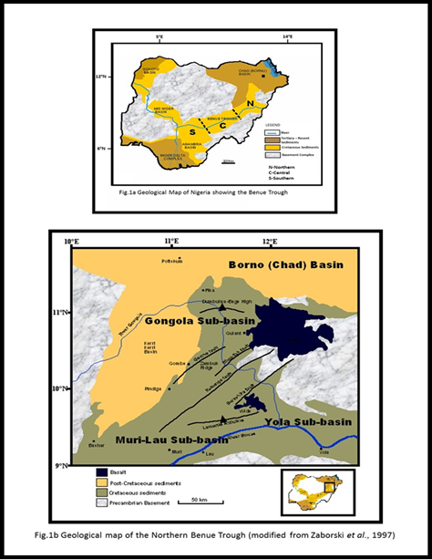
The phase following the mid-Cretaceous global transgressive event, emplaced a regressive condition in most of the basin in the West and Central African Rift System setting in the evolution of the Gombe Formation in the Gongola Sub-basin of the Northern Benue Trough [1], [2]. This trough (Fig.1), developed due to the separation of the South American from the African plates during the Late Jurassic to Early Cretaceous times, but its origin and evolution remained highly controversial with two theories prominently adjudged to give the most resounding postulations. The earliest rift model theory supported to date [3], [4], [5], [6] suggested development through tensional regimes induced by mantle plume convectional activities [7]. In opposition to this theory, considering the lack of evident boundary faults in this model, the pull-apart model was proposed because the major strike-slip faults of the sub-basin are in same orientation of the major transcurrent fault systems of the Romanche, Chain and Charcot suture zones [8], [9], [10] hence, a strike-slip tectonic origin. The opening of the trough in the post Aptian-Albian is accompanied by transgressive event the rouse up to the Campano-Maastrichtian times thereby depositing transitional-marine sequences across the Benue Trough. This researched aims to evaluate the facies and facies associations of this Gombe Formation at Gombe University stream, Gabukka stream and Doho village that represents some of its major outcrops in the Gongola Sub-basin in order to establish depositional model that characterizes its development at these localities.
2. GEOLOGICAL AND STRATIGRAPHIC SETTING
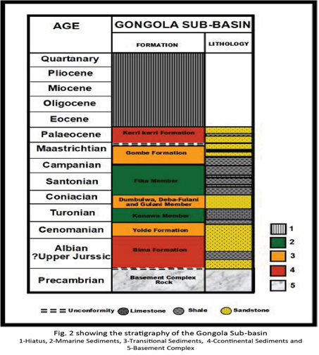
The Benue Trough is part of the Cretaceous rift that falls into the Central and West Africa Rift System, extending in an NNE-SSW orientation for about 1000 km in length and 50-150 km in width [5], [10]. Its southern limit falls on the northern boundary of the Niger Delta, whereas the northern fringes at the Dumbulwa-Bage High, aligning to the southern boundary of the Chad Basin (Fig.1) [11]. The Benue Trough is geographically and arbitrarily subdivided into Northern, Central and Southern Benue Trough (Fig.1). The Northern Benue Trough constitutes of three arms: The N-S striking Gongola Arm, E-W striking Yola Arm and the NE-SW striking Muri-Lau Arm [12] (Fig.2). The Trough host over 6000 m of Cretaceous to Tertiary sediments of which those predating the mid-Santonian have been tectonically deformed, to form major faults and fold systems across the basin. The Bima Group of the Aptian-Albian represents the oldest sedimentary units in the Gongola Sub-basin, conformably overlying the Basement Complex Rocks (Fig.2) [13], [11], [14], [15]. The syn-rift sequences thereof are largely controlled by the horst and graben systems and is represented by the alluvial fan-lacustrine deposits of the Bima I Formation, the lowermost in the group, which is unconformably overlain by the post-rift braided river dominated Bima II and III Formations [11], [14], [15]. The Yolde Formation conformably follows in the Cenomanian, marking the development of transitional-marine deposits in the basin [16], thus representing the onset of the mid-Cretaceous global marine transgression therein [e.g. 2]. This transgression climax in the Turonian and deposited the shallow marine shale and limestone sequences of the Kanawa Member of the Pindiga Formation [11], [17]. Deceleration of this regime in the mid-Turonian developed regressive series of the Sandy Members of the Dumbulwa, Deba-Fulani and Gulani Sandstones (Fig.2) [11], [10]. Renewed surge in the relative sea levels in the late Turonian transcending into the Coniacian and early Santonian brought about the deposition of the deep marine blue-black shales of the Fika Member, representing the youngest units of the Pindiga Formation [11], [18]. This marine transgression is accompanied by compressional tectonics in the mid-Santonian [19], as consequence of changing orientation of the displacement vectors between the African plate and European/Tethys plates [20]. This led to thrusting of the pre-Maastrichtian sequences towards the western regions of the Gongola Sub-basin, thus creating an accommodation for the evolution of the Campano-Maastrichtian regressive deposits of the Gombe Formation [21], [18]. Another compressional tectonic phase is experience in the mid-Maastrichtian and this is followed by the unconformable deposits of the Paleogene continental Kerri Kerri Formation [22], [23] (Fig.2). The Paleogene-Neogene phase of the sub-basin is characterized by volcanics, most commonly align along the eastern margin of the Gongola Sub-basin [24].
3. MATERIALS AND METHODS
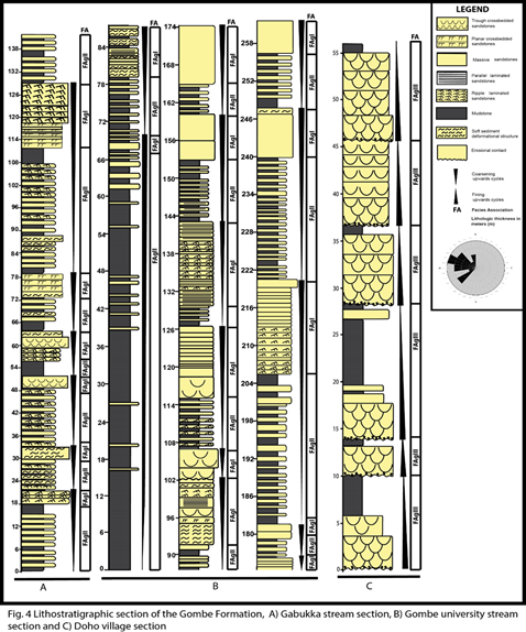
Topographic maps of Gombe town and environ that falls into the Gongola Sub-basin were employed in the fieldwork exercise of this research so as to identify potential areas where the Gombe Formation are well exposed. Along these well exposed outcrops identified, lithostratigraphic sections of this Formation outcropping around Gabukka and Gombe State University streams (Fig. 4) were systematically logged to record data on lithologic variations, texture, bed geometry, paleocurrents, sedimentary structures and fossil content. Based on facies concept and application of Walters law in conjunction with facies relation provided by sedimentological studies on ancient and modern environment, these data were utilized in designating lithofacies assemblages representing particular depositional environment. Paleocurrent measurements were also carried out on the abundant planar and trough crossbedded sandstones and the various orientations determined were used to evaluate provenance and hydrodynamic processes [e.g. 25]. The dip and strike as well as the azimuth of the crossbeds were measured using compass clinometers in this analysis, and considering that the regional dip of the beds are generally greater than 10o, tilt correction was also carried out on the values using the procedure adopted by [25].
4. RESULT
4.1. FACIES ANALYSIS
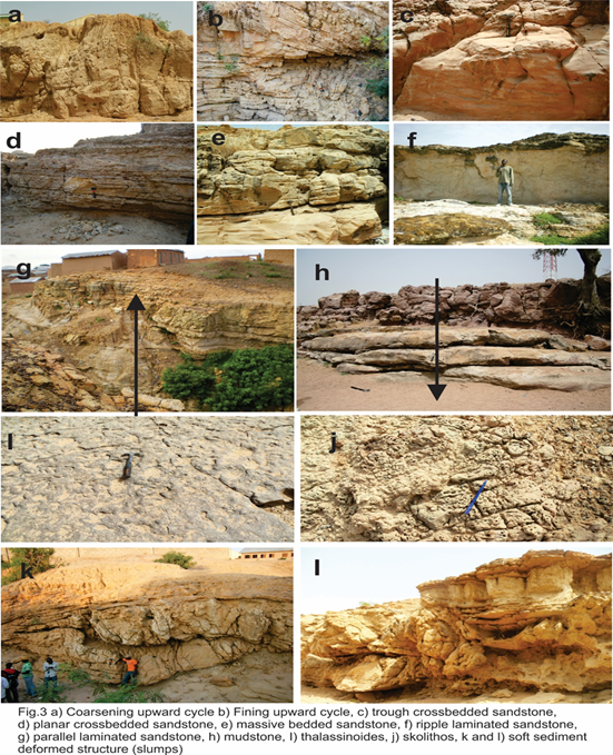
Facies St: Trough crossbedded sandstone facies
This lithofacies composes of fine –very coarse-grained sandstone, dominantly moderately sorted with sub – angular to sub – rounded grains, ranging in thickness from 1 – 1.2 m. They commonly compose of erosional basal boundaries when coarse grained, typically associated with mudcast and dominantly bioturbated when fine grained (Fig.3a). This lithofacies was interpreted to have formed from migrating sinuous 3-D dunes that stack up to generate bar forms in channel [26], [27], [28], [29], [30].
Facies Sp: Planar crossbedded sandstone facies
This lithofacies composed of fine – medium grained sandstone with sub – rounded to well-rounded grains and commonly overlain trough crossbedded and massive sandstone facies with thicknesses in the range of 30 – 80 cm, individual foresets ranged from 3 mm – 25 mm and they are commonly bioturbated (Fig.3b). This lithofacies was interpreted to have been produced from migration of 2-D dunes or sheet loading and/or interpreted as transverse bars formed under lower flow regime [25], [30].
Facies Sm: Massive sandstone facies
The massive sandstone facies are well to moderately sorted with grain sizes in the rangeb of fine – coarse grained and are most commonly bioturbated. It ranges between 5cm– 1m in thickness and occurs associated with ripple laminated sandstone facies (Sr) (Fig.3c). This facies is generally deposited as plane beds in lower flow regime and/or rapid sedimentation due to high deposition rates with no preservation of sedimentary structures. It is commonly deposited on bars by stream floods and mostly associated with channelized flood flows around bars [28], [30].
Facies Sr: Ripple laminated sandstone facies
The ripple laminated sandstone facies compose of fine–very fine-grained sandstone, but occasionally medium grained. Grains are well sorted and well rounded. Thicknesses ranges from 20–35cm and it is mostly underlain mudstone facies and massive bedded sandstone facies (Fig.3d). Asymmetrical forms commonly dominate and they are mostly bioturbated. This facies forms either when the water surface show little disturbance, or when water waves are out of phase with bedforms during lower flow regime, or forms through migrating current ripples, under lower flow regime [33], [29], [30].
Facies Sl:
Parallel laminated sandstone facies
This
lithofacies is generally fine grained with thicknesses ranging between 10 – 30
cm. It is commonly associated with trough crossbedded sandstone facies (St),
ripple laminated sandstone facies (Sr) and mudstone facies (Fm). Bioturbations
and mica flakes are commonly associated attributes and boundaries are generally
sharp. Laminations mostly show variation in grain size or mineral composition
(Fig. 3e). This facies is produced by less severe or short-lived fluctuations
in sedimentation conditions than those that generate beds. They result from
changing depositional conditions that causes variation either in grain size,
content of clay and organic material, mineral composition or microfossil
content of sediments [25].
Facies Fm: Mudstone facies
This lithofacies is dominantly whitish but grey units are also prevalent. Bioturbations are common and thicknesses ranges from 30cm – 1.7m. It is usually interbedded with ripple laminated sandstone facies (Sr) and massive sandstone facies (Sm) or define the base of trough crossbedded sandstone facies (Fig.3f). This facies forms under environmental conditions where sediments are abundant and water energy is sufficiently low to allow settling of suspended fine silt and clay. They are characteristic of marine environment where seafloor lies below the storm base, but can form in lakes and quite part of rivers, lagoons, tidal flat and deltaic environment [25], [33].
5. SEDIMENTARY FACIES CHARACTERIZATION
The lithologs of the
Gombe Formation in the Gongola Sub – basin show coarsening upward cycles at all
the studied locations (Fig.3g), except the Doho village junction section, which
displayed fining upward cycles (Fig.3h). These coarsening upward cycles typically
compose of thick claystone/mudstone at base passing into succession of
interbedded fine-grained sandstones and whitish to grey shales or claystones in
the middle, and to thick light brown fine to medium grained sandstone at top.
The thick claystone /mudstone or shales usually occur in varying thickness
(60cm – 1.7m), which tends to reduce in the uppermost cycles of the formation.
The greenish to brownish shales generally display several levels of
bioturbation with Thalassinoides
burrows being the most common (Fig. 3i). The whitish clays are less
bioturbated. The interbedded fine-grained sandstone and claystone occurring in
the middle part of the cycle ranges in thickness from 1.2 – 23m. These units
compose of ripple or parallel laminated sandstone that are highly bioturbated,
but few units of massive beds are also present. The thick light brown to
reddish sandstone occurring in the topmost part of the coarsening upward cycle
are 2.5m – 14m thick, and are dominantly composed of trough crossbedded sandstone
and massive sandstone. Locally, planar crossbedded sandstone and ripple and
parallel laminated sandstone are also common. Soft sediment deformational
structures are also occasionally present (Figs.3k and l). Above the coarsening
upward cycles occur a vertically stacked red to maroon coloured massive
sandstone. These are only recorded at the Gabukka stream and Gombe State
University stream sections (Fig.3g), and are medium – coarse grained, with
thickness ranging between 1.3 – 3.1 m.
The section along the Doho village junction consists of fining upward
cycles of light grey trough crossbedded coarse grained sandstones (2.1 – 5.7m
thick) with erosional contact associated with mudclasts at the base which
temporally transit into grey claystones of about 2.5 – 5.2cm thick (Fig. 3h).
6. LITHOFACIES ASSEMBLAGE
The lithofacies in the Gombe Formation were grouped into three facies associations: bedded sandstone facies association (FAgI), interbedded sandstone and mudstone facies association (FAgII) and amalgamated trough crossbedded sandstone facies association (FAgIII)
Association FAgI: Bedded sandstone facies association
This facies association (Figs.4a and b) is dominantly defined by well sorted, very fine – fine grained sandstone units that range in thickness from 2 – 27m. It composes of trough crossbedded sandstone facies (St), ripple laminated sandstone facies (Sr), parallel laminated sandstone facies (Sl) and massive sandstone facies (Sm), but the association of these facies varies across the localities studied. It predominantly composed of trough crossbedded sandstone facies (St) ranging in thickness from 3 – 6m. The occurrence of planar crossbedded sandstone facies (Sp) in the FAgI was only identified at the Gabukka stream (Fig. 4b) with bed thickness of between 1.5 – 2m and foreset thickness of 1 – 2.5cm. The thickest units (up to 27m) of this facies association were recorded at F.C.E. and Gombe State University stream (Fig.4a). At these locations it is defined by ripple laminated sandstone facies (Sr), parallel laminated sandstone facies (Sl) and massive sandstone facies (Sm), typically occurring as sub – amalgamated bedded sandstones with individual beds ranging from 10 – 50cm thick.
Association FAgII: Interbedded sandstone and mudstone facies Association
This facies association (Figs.4a and b) is composed of interbedded sandstone and mudstone facies (Fm). The sandstone consists of ripple laminated sandstone facies (Sr), parallel laminated sandstone facies (Sl) and massive sandstone facies (Sm), with thicknesses ranging between 10 – 40 cm. The mudstone facies (Fm) ranges in thickness between 20 cm – 1.8m. It is dominantly whitish in colour at the middle – upper part and grey – dark grey at the basal part of most sections (Figs. 4b and c), where it is severely bioturbated and contains Thalassinoides burrows.
Association FAgIII: Amalgamated trough crossbedded sandstone - mudstone facies association
This facies association was only observed at the Doho village junction section (Fig.4c) and composes of fining upward cycles of 6 – 18m thick, defined by coarse grained, poorly sorted trough crossbedded sandstone facies (St) with erosional contacts and pebble lag deposits at base, capped by mudstone facies (Fm) of 1 – 1.5m thick (Fig.4c).
7. DISCUSSION
Deltaic systems are
zones of seaward perturbation of land, where the rate sedimentation and
discharge outrun accommodation creation, depicting a spatio-temporal profile
characterized by fining upwards symmetry at its upper stratigraphic horizon
typical of a fluvial system and an underlying coarsening upward signature
typifying a delta system [30]. This architecture is in consonance with the
facies association and successions of the Gombe Formation that showcases
coarsening upward cycles at its lowermost horizon that graded into fining
upward package depicting a paleogeographic coastline with adjacent elevated
hinterlands that emplaces a depositional profile, promoting seawards
trajectories. The base of the Gombe
Formation in this study was taken at the first stratigraphic appearance of
bioturbated very fine-grained sandstone within the thick glauconitic claystone,
because the bioturbated very fine-grained sandstone may be considered part of
the terrigenous input that developed the coarsening upward cycles. Thus, considering
this profile and architecture of the facies associations thereof, it was
suggested that the Gombe Formation must have formed under deltaic depositional
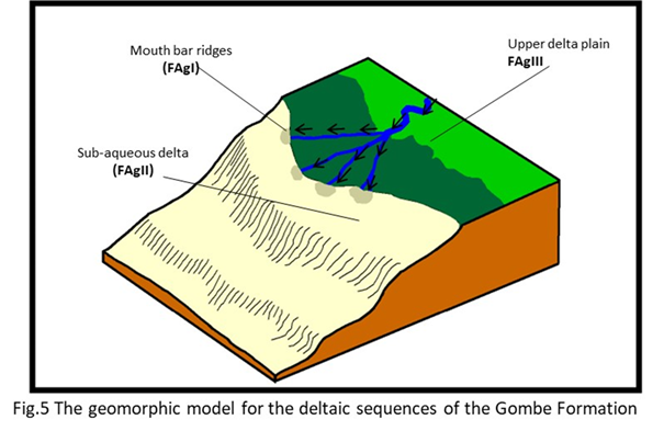
environment [e.g.21]. Pro-delta to delta slope sequences are reflected
by the interbedded sandstone and mudstone
facies association (FAgII) of the coarsening upward cycles whereas the bedded
sandstone facies association (FAgI) are defined the mouth-bar sequences.
Records indicated that the facies (Sr, Sl, Sm, Sp and St) of the bedded
sandstone facies association defining the upper part of these cycles are very
common in distributary mouth bar deposits of a deltaic system [35], [34]. The changing thickness of this profile
signals the changing dynamics in the sedimentary budget supply and the rate
creation of the accommodation space [36]. The abundant syn-depositional slump
structures in the mouth-bar sequences may indicate pulse of high sediment
overloading due to excessive and rapid sediment influx, this create sediment
instability and subsequent deformation, typical of a delta [37], [38]. The high sedimentation rate is supported by
the lack of bioturbations in most of these sandstones, because intense
bioturbation occurs only during quite water conditions ([39], [40]. Mouth-bar sequences are constantly subjected
to reworking, not only by stream currents but by waves generated in the open
marine waters beyond the channel mouth and these processes results in cleaning
and sorting of the sediments, giving rise to well sorted sands [41], [34]; [42] as depicted in the Gombe Formation as the
case under study. The occurrence of Thalassinoides and skolithos ichnofauna in
the pro – delta claystones, siltstones and sandstones (FAgII) may suggest that
the water depth in which these sediments were deposited may be up to 30 m [43]. The amalgamated trough crossbedded
sandstone facies association (FAgIII) presumed to be emanating from the elevated
hinterland region represents the upper delta plain in the deltaic prism of the
Gombe Formation. Absences of thick in the channel symmetry, indicating high
channel to floodplain ratio devoid of point bar facies signatures may suggest
that the fluvial packages are that of braided river system. These coupled with
the dominances of unidirectional current pattern in all the facies assemblage
and lack of wave and tides modulation therein may indicate deposit of a fluvial
– dominated delta (Fig.5).
8. CONCLUSION
The facies characterization and evaluation of the Gombe Formation of the Northern Benue Trough indicated the occurrence of six lithofacies that consist of trough crossbedded sandstone, planar crossbedded sandstone, massive bedded sandstone, ripple laminated sandstone, parallel laminated sandstone and mudstones. Three distinct associations of these lithofacies gave rise to three facies assemblages, constituting of bedded sandstone facies association, interbedded sandstone and mudstone facies association and amalgamated trough crossbedded sandstone facies association. These assemblages are characteristics of deltaic system, with marked differentiation of upper delta plain, delta front sands and subaqueous delta. The absences of influence of tide and wave in the stratigraphic architecture of the Gombe Formation coupled with the imprints of unidirectional current system indicates that the formation represents a fluvial dominated delta.
SOURCES OF FUNDING
This research received no specific grant from any funding agency in the public, commercial, or not-for-profit sectors.
CONFLICT OF INTEREST
The author have declared that no competing interests exist.
ACKNOWLEDGMENT
None.
REFERENCES
[1]
Shaw,
D.P. Time in Stratigraphy. McGraw-Hill, New York. 1964: 34.
[3]
King,
L.C. Outline and distribution of Gondwanaland. Geol. Mag. 1950: 87: 353-359.
[12] Nwajide, C. S. Geology of Nigeria’s
sedimentary basins. Lagos, CCSBookshop Ltd. 2013: 45-89.
[31] Miall, A. D. The Geology of Fluvial Deposits.
Berlin, Springer-Verlag. 1996: 582p.
[32] Miall, A.D., Alluvial deposits. In: James,
N.P., Dalrymple, R.W. (Eds.), Facies Models 4. Geological
Association of Canada, St. John’s, Newfoundland: 2010: 105-137.
[34] Bhattacharya A. P. Deltas. SEPM Special Publication. 2006: 84:
237–292.
|
|
 This work is licensed under a: Creative Commons Attribution 4.0 International License
© Granthaalayah 2014-2020. All Rights Reserved.