
|
|
|
|
ENVISIONING SUSTAINABLE LANDSCAPE MANAGEMENT IN THE ENVIRONMENTALLY SENSITIVE AREAS OF KSOUR ESSEF, TUNISIAFaiza Khebour
Allouche 1, 2, Saida Hammami
1, Arwa Hamaideh 3
|
|
|
|


Article Type: Research Article
Article Citation: Faiza Khebour Allouche, Saida Hammami, Arwa Hamaideh, Emna Gatta, and Anas Khasawneh. (2021). ENVISIONING SUSTAINABLE LANDSCAPE
MANAGEMENT IN THE ENVIRONMENTALLY SENSITIVE AREAS OF KSOUR ESSEF, TUNISIA. International
Journal of Research -GRANTHAALAYAH, 9(1), 85-98. https://doi.org/10.29121/granthaalayah.v9.i1.2021.2715
Received Date: 11 December 2020
Accepted Date: 27 January 2021
Keywords:
ESA
Landscape
Diagnosis
Urban Natural
Park
ABSTRACT
Each territory has distinctive features and landscape compositions that contribute to the creation of territorial identities. Natural parks are territories remarkable for their wealth of biodiversity, which in turn contribute to the development of sustainable socio-economic development through landscape enhancement. The main idea of this research is to test the combinaison of two concepts to propose a suitable management in a semi-arid environment. It is based on the use of the ESAs and landscape diagnosis concepts. The concept of ESAs is supported including the need to identify environnementally sensitive lands based on the hypotheses of MEDALUS project model. However, the landscape diagnosis is based on the combination of landscape potential and social requirements. Results aimed to create ecological and environmental models based on natural materials such as wood, light minerals and a diversified and multicoloured plant palette, including the logic of working with nature and preserving its particularity by promoting sustainable local development criteria and create a new green city.
1. INTRODUCTION
Since the early
19th century, forests have been the scene of urban growth and have sometimes
been transformed into green and wooded areas or urban forest parks. With the
evolution of large urban areas, the need for space for new construction has
caused problems following deforestation, fires and the
degradation of peri-urban natural areas. Today, despite these disadvantages,
several countries have become more aware of and respectful of peri-urban
forests through the development of fields of activity in these areas. Forests
are multifunctional spaces, offering both tangible and intangible services. In
Japan or Australia, the demand for recreational spaces has encouraged public
authorities and local authorities to invest in forests to benefit from their
environmental and social functions. In France, the social perception and
representation of forests are very closely linked to
leisure activities (Papillon,
2014). In
Tunisia, peri-urban forests were transformed into public parks in the summer
following the program of 100 parks that began in 1996. The objectives of
creating these parks are essentially to improve the living conditions of city
dwellers and to preserve the natural spaces adjacent to the cities. Among the
forests that have been transformed into public parks are (Nahli,
El Mourouj, Farhat Hached,
El Hmeda,...). Today, these forests converted into
peri-urban parks do not meet society's needs for a pleasant natural living
environment and also for leisure. Peri-urban forests
require new recognition and also a rethinking of their
future. The example of the Ksour Essef
peri-urban park is our study support, in order to
assess its current state and propose solutions that can remedy the
disadvantages and offer the target population a better living environment in
order to preserve natural resources while meeting the requirements of
sustainable development. Generally, landscaping projects are
based on landscape analysis, this research work consists in presenting a method
of evaluating the landscape features of a regional forest natural park which
has been developed in 2011 but has undergone a significant degradation of
natural and managed entities following the effect of climate change and
anthropogenic especially after the revolution. The status of sensitive
environmental areas will be assessed by applying the Medalus
method. Then, a landscape diagnosis is carried out on the ground. The
comparison of the results will enable to better manage the studied space and
propose a sustainable landscaping taking into account
the three pillars of sustainable development.
2. STUDY AREA
The park is located in the delegation Ksour Essef belongs to the
governorate of Mahdia and occupies an area of 16
hectares which implanted in a forest of an overall area of 50
hectares (Figure 1). This space was actually an old
stone quarry in the sixties, which after its closure in 2001, was promoted as a
green space. It occupies the highest point of the city whose altitude can reach
up to 66 m. This forest represents the green lung of the city, thus, it is
formed of an afforestation of Aleppo pine "Pinus Halepensis"
and Eucalyptus "Eucalyptus
Camaldulensis". The development of the park is part of the national
parks program that brings together 100 parks throughout Tunisia to improve the
living environment of the population and the protection of the environment. It
was open, according to the municipality of Ksour Essef, in 2002 and was valued as a forest park. Indeed, a wrought iron
fence was put in place to demarcate the park and protect it with an entrance
gate made by AUDEC (2002), with a sum of 28 thousand dinars. Inside the park, a
fitness trail was set up in 2011 with all the physical work equipment, a
refreshment bar, a play area, a "LABIB" pedestal and family rest
areas with benches. But since the Tunisian revolution, in 2011, the space was
destroyed and poorly maintained, therefore, it became non-functional and a wealth
of landscape was lost including the components of the course.
The delegation of Ksour Essef
belongs to the governorate of Mahdia located
south-east of the Tunisian sahel, 200 km from the
capital Tunis and 12 km from the city of Mahdia with
an area of 40 Km² and 54 366 inhabitants in 2014. It is located
on a moderate hill, and encloses a coastal zone stretching 13 Km (Figure 1).
According to the National Meteorological Institute of Tunis (2017), the city of
Ksour Essef is known for a
warm, dry Mediterranean climate in summer, humid and temperate in winter with a
maximum average temperature of 31 ° C and a minimum average of 6 ° C. The city
is also known by winds on the east side in summer and on the west side in
winter, whose west winds are dominant and can reach up to 80 m/s. Potential
evapotranspiration (PET) varies from 1319 to 1321 mm / year in 2010. According
to the Regional Commissariat for Agricultural Development (CRDA, 2014), Ksour Essef contains the water
table "Melloulech", where 1446 water wells
produce 2.91 million m3/year with a variable salinity between 3 to
15 g/l. It belongs to the "Sahel Sfax" water table, consisting of 22
water wells, producing 3.15 million m3 of water. The Territorial
Extension Cell (CTV, 2002), has mentioned that the irrigated perimeters at Ksour
Essef occupy a total of 110 hectares spread over 152
farmers. It despites a water salinity of 4.3 g/l of
salt. However, Ksour Essef is
built on a succession of hills with altitudes that vary between 6 m and 30 m
and the neighboring altitude hills reaches 65 m.
|
|
|
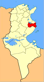
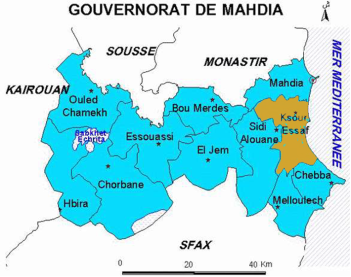
Figure 1: Location
of Ksour Essef city, Tunisia
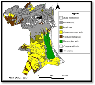
The delegation of Ksour Essef is home to several types of soils, and the
predominance of low input soils, isohumic soils and raw mineral soils on the north
side. In the southern part, the soils are raw limestones, while in the center
there is a diversity such as halomorphic soils, rendzines and complex units.
The raw mineral soils are located on a steep slope where the surface layers are
constantly entrained thus preventing the formation of soil from which the
vegetation cover is very insignificant. This type of soil is mainly present in
the northern and north-eastern part of Ksour Essef, with a succession of hills
reachs 66 m. The poorly evolved soils are generally located in semi-arid areas,
characterized by a low degree of weathering, a humic horizon and a structure
that is often weak. Isohumic soils are characterized by a dominance of clays
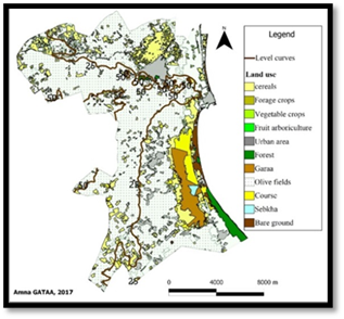
found in the forest of Ksour Essef (Figure 2). The land use of the town of
Ksour Essef is subdivided into two parts: the coastal side presents a variety
of crops including cereals (barley and wheat), forage crops (sorghum, maize,
oats ...), market gardening (pepper, tomato, potato, zucchini, cucumber,
carrot, onion, melon, eggplant, pea, squash, watermelon, garlic ...), spices
(cumin, choriambe) and olive groves. Further, cereal crops persist in the west
one (Figure 3).
|
|
|
|
Figure 2: Different soil types of the Ksour Essef
delegation, Tunisia |
Figure 3: Different soil types of the Ksour Essef
delegation, Tunisia |
The commune of Ksour Essef, contains 12 green spaces with a total area of
353,950 m2 distributed as follows:
·
Habib Bourguiba Street Garden: 2500 m2 (under
redevelopment)
·
Hedi Chaker Street Garden: 1850 m2 (in
redevelopment study)
·
Ahmed Tlili Street Garden: 1,800 m2 (requires
maintenance)
·
Omar Karchoud Street Garden: 400 m2 (requires
maintenance)
·
Ali Bouzidi Street Garden: 2000 m2 (in
redevelopment study)
·
El Hmeda Park: 160 000 m2 (in redevelopment
study)
·
Garden Aziza Othmena street: 78 300 m2 (corner
bush)
·
Garden rue Salah Eddin El Ayoubi: 20 100 m2
(corner bushed)
·
Garden Bizerte street: 8200 m2 (bushed area)
·
Garden Jbal Khmir street: 78 400 m2 (corner
bush)
·
Garden Street 2 Mars: 300 m2 (in redevelopment
study)
·
Garden street Abdallah Chaweli: 100 m2 (corner
bush).
The delegation of Ksour Essef has a population of 54,366 inhabitants in
2014. The economic development of the city of Ksour Essef is based on the trade
where there are more than 300 points of sale in detail. The participation rate
is 38.87 % while the unemployment rate is 9.83 %, which shows that despite the
reduction in the number of jobs in the city, agriculture and commerce provide a
lot of jobs (INS, 2014). During the last five years, the city has undergone
remarkable development especially in the administrative, health, educational,
sports, cultural, religious and commercial (Monoprix, Carrefour, etc.).
3. METHOD
Urban Natural
Parks are designed to preserve and improve the quality of the landscapes and
the living environment of the inhabitants. As a result, the need for green
spaces in cities is becoming a necessity, and city dwellers are looking for
moments of relaxation, rest, recreation, outdoor activities and sports where
nature is very calm. In this strategy
that the municipality of Ksour Essef has requested a proposal for the
redevelopment of the El Hmeda natural urban park, which is part of the
sustainable development project of Mahdia city.
In response to this request, the objective of this research is to
propose a landscaping redevelopment in this park. The methodological approach is based on the
ESA approach and the landscape analysis dealing with the different physical,
sensitive and natural aspects and the development proposal is based on the
concept "Treasure Hunt". In order to
understand and act effectively on the Ksour essef park, we opt for an
analytical approach based on diagnosis and evaluations, as shown in Figure 4,
different steps followed in the methodological approach.Two principal steps are
used the landscape diagnosis and the ESA assessment of park El Hmeda
The
physical diagnosis is based on the use of Google earth, open street map and
some shapefiles. Google earth and field validation using GPS are done for
digitizing and mapping the spatial delimitation of the park, slope and altitude
variation for two transects, it’s land use cover and field description of some
stations. The park accessibility is mapped using Open street map tool and some
benchmarks are located. However, sensitive analysis is based on the visual
interpretation of the landscape structure (vertical and horizontal), noise, and
colors in order to evaluate its state. The survey conducted as part of this
research, aims to know the expectations of the resident population around the
forest of El Hmeda and visitors to approve our idea of design.
Ten questions in total were asked, out of 50 people, some are asked in a
socio-economic context such as age, sex, the budget devoted to leisure, the
distance between the park and the housing of the person surveyed. Others are
asked to better understand the strengths and weaknesses of the space, the
reasons for the visit, the preferred locations and the expectations of the new
landscaping.
The use
of this diagnosis method is based on the hypotheses of MEDALUS project model
(Giordano et al., 2007). Three qualitative indexes are computed by applying an
average of a geometrical model. The following three quality indices were
computed;
·
Soil
Quality Index (SQI),
·
Vegetation
Quality Index (VQI)
·
Climatic
Quality Index (CQI)
Administrative, land use
land cover and sol Mahdia vector layers are used to map and calculate indexes.
DEM raster layer was downloaded from https://glovis.usgs.gov/ and used to
retrieve the slopes and aspect gradients. The data (spatial resolution of 30 m).
The evaluation of
ESAs is based on a combination of the physical including soil, climate, and
vegetation qualities. A geodatabase and several thematic maps were prepared and
standardized with the same projection system and spatial resolution. The indicators
were grouped into four quality indices, namely, the soil quality index (SQI),
climate quality index (CQI), vegetation quality index (VQI), and MQI (Khebour Allouche and Gad, 2014). Each indicator was calculated
by means of sub-indicators, which were also classified. For each class, a
weight value was allocated. The values of the weights varied from 1 (least
sensitive to desertification), to 2 (most sensitive to desertification) (Gad
and Lotfi, 2008).
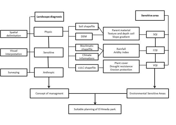
Figure 4: The landscape diagnosis and the ESA assessment of park El
Hmeda, Tunisia
3. RESULTS AND
DISCUSSION
3.1. ASSESSMENT OF SENSITIVE
AREAS
A large part
of the park is located in a quaternary formation. The quaternary part includes
terraces of major bed, mobile sand, unconsolidated scree, low terraces,
dejection cones, and white limestones, probably lacustrine and often
conglomeratic. Furthermore, the Ordovician part contains sandstone, quartzites,
and claystone. Soils derived from different parent materials react differently
to erosion, absorbency and production of biomass: the presence of pebbles still
causes an increase in runoff and therefore improved safeguard from
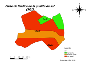
desertification (Figure4). The influence of each class for each sub-indicator
constructs SQI that was weighted based the influence on desertification
process. More than 50% of the area is marked by less sensitive soils. A strip which
crosses this entity in the center of the forest area is marked by moderately
sensitive soils. These landscape conditions encourage sensitivity to land
degradation. Calculating
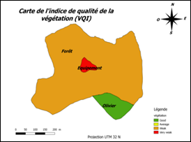
the vegetation quality index, on basis of the previous parameters reveal that
the 60 % of the vegetation cover is very weak and sensitive to desertification
(Figure5). The good vegetation index class which may resist desertification is represented
olive plots. The Hmeda park have an average of a precipitation of 283mm/a and
the PET is inferior to 1300 mm/an. So, the climatic quality index is inferior
to 0,217. That’s why all the field have a weak climatic index. Figure 6 show
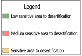
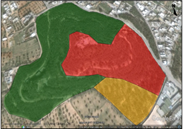
the distribution of ESA’s. It is clear that most of the Hemeda park is
moderately sensitive to desertification (60 %) and the very sensitive area is
located in the east.
|
|
|
|
Figure 4:
SQI map of El Hmeda park |
Figure 5. DSI map of El Hmeda park |
|
|
|
|
Figure 6: ESA’s for desertification in El Hmeda park |
|
Through
the geographical evaluation of the park, in order to qualify the different
biotic (plant and soil) and abiotic (climate) components, it can be concluded
that the El Hmeda peri-urban park is a natural space whose distribution of
natural resources is not very equitable throughout the park, which leads to
rethink landscape development through conservation and remediation planning. In
this respect, a landscape analysis is essential to meet the requirements of a
functional and sustainable development.
3.2. LANDSCAPE ANALYSIS
3.2.1. PHYSICAL ANALYSIS
The
physical analysis is based on the description during field visits and the use of
digital media such as Google Earth, Google maps and QGIS 1.18. The park is accessible
from the Mahdia-Ksour Essef road via Rojich on the north side or on the west
side by the Salakta-Ksour Essef road. It is surrounded by three types of
landscapes: an urban landscape constituting the center of the city of Ksour
Essef, a peri-urban landscape formed by the extensions of the city and a wider
agrarian landscape formed by olive groves. The slope in the park to be
redeveloped is very specific which gives it a unique charm following the
variation of the slopes, the division of the land into three terraces and
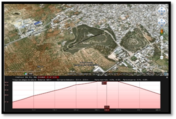
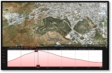
rugged terrain. A longitudinal plot shown in Figure 7 shows that the park
represents a variation in altitude between 27 m and 58 m. While the transverse
plot of the same figure indicates a variation between 32 m and 61 m.
|
|
|
a. Variation of altitudes
in horizontal b. Variation of
altitudes in vertical
Figure 7: Altitudes variation in Ksour Essef park
Aleppo pine occupies more than 90 % of the total area of the
park with variable densities shown in Figure 8. The northern part represents a high-density
Aleppo pine plantation, the eastern part contains a medium density and the
Southern part is rather at very low density. These woodlots are crossed by
trails and tracks representing respectively 23 % and 77 % of accessible linear
parts ensuring the circulation throughout the park.
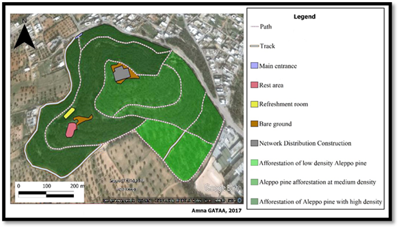
Figure 8: Components
and circulation in the Ksour Essef Forest Park, Tunisia
GPS points were taken during the field trip using the Garmin Map 64S. Table
(5) shows the description of some stop stations where GPS points were taken.
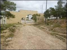
The first station corresponds to the main entrance on the north side,
characterized by rough terrain and a destroyed fence. The second station is
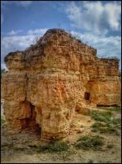
related to one of the caves constituting the park. Stations 3 and 4 present the
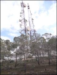
local and distribution pole of the network. And the last station is a secondary
entrance on the south-east side.
Table 1:
Description of some the forest parc Ksour Essef stations
|
Station number |
Description |
|
|
Station 1 |
X: 35°24’49.77’’N Y: 10°58’47.90’’E Elevation: 34 m |
Main entrance to the park (North side) |
|
The entrance to the park is totally destroyed: the lack of doors and fences makes the space insecure, in addition it suffers from rainwater runoff that causes the slope of the land and the difficulty of the movement of visitors. |
||
|
Station 2 |
GPS measurement 839 X: 35°24’46.32’’N Y: 10°58’48.16’’E Elevation: 40 m |
Cave of the old quarry |
|
The caves present the identity of the space since they represent the traces of the old stone quarry. |
||
|
Station 3 |
GPS measurement 843 X: 35°24’43.87’’N Y: 10°58’51.74’’E Elevation: 60 m |
Network distribution construction |
|
The distribution construction of the network destroys the continuity of the landscape. Indeed, the mineral represents a foreign body in the succession of the plant. |
||
|
Station 4 |
GPS measurement 844 X: 35°24’47.85’’N Y: 10°58’52.81’’E Elevation: 62 m |
Distribution pole of the network |
|
The distribution pole of the network causes harmful waves for the fauna and flora of the forest, and even for the visitors of space. |
||
|
Station 5 |
GPS measurement 849 X: 35°24’38.48’’N Y: 10°59’03.62’’E Elevation: 36 m |
Secondary entrance on the south-east side |
|
A secondary entrance near the college allows students to visit the park and use it especially during off-peak hours. |
||
3.2.2. SENSITIVE ANALYSIS
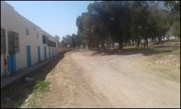
The park represents the green lung and the only virgin space in the city.
It is a vast place that gives the impression of freedom. The game of altitudes presents
the strongest point, it offers an open panoramic view allowing to even the
whole city of Ksour Essef and even its peripheries. However, the park lacks
dynamics and flexibility as the verticality of conifers dominates with a
yellowish-green color and more yellowish in places reflecting the soil giving
the impression of sadness and emptiness. The slopes are also a weak point; for
example, the lower part of the park on the north side is the most damaged
mainly by rainwater runoff and there the terrain becomes very rough and makes
the movement very difficult especially for the elderly. Thus the lack of water,
lighting, furniture and especially security makes the space abandoned (Figure
9).
|
Open panoramic view of the highest
point of space |
Large space |
|
Dominance of verticality and
yellowish-green color of "Pinus Halepensis" |
Rainwater runoff damage (North Main
Entrance) |
|
Original vegetation of the forest |
Lack of fence and door |
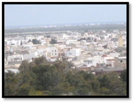
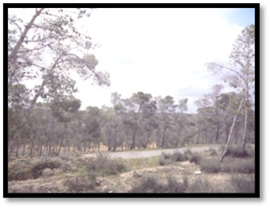
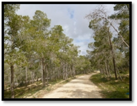
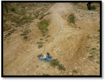
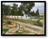
Figure 9: Some
examples illustrating the sensitive analysis of Hemada Park, Tunisia
3.2.3. ANTHROPIC ANALYSIS
Figure 10 shows that age groups of visitors are divided into 5 classes. The
park is more visited by adults, whose age is over 50 years (26%), then comes in
second place the class of visitors aged between 40 to 50 years. 20% is the
percentage of visitors for both classes in the 30 to 40 and 20 to 30 age
groups. The lowest percentage, 10%, represents the class of the youngest
visitors (10 to 20 years old). In addition, 54% of visitors are represented by
the male sex, while the female sex represents only 46%.
|
|
|
Figure 10: Percentage
change in age groups (left) and visitor gender (right) of El Hmeda Park
The majority of park visitors come from Ksour
Essef (58%) and Salakta (42%). Thus, 28% of visitors take five minutes by car
to access the park and 24% of visitors arrive on foot.
|
|
|
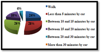
Figure 11: Percentage
change in visitor origins (left) and time required to access (right) El Hmeda
Park, Tunisia
The percentages of park attendance range from 4%
to 30%. From Figure 30, we note that the majority of visitors go to the park
infrequently and 28% of visitors have never visited it, this is their first
visit. The frequency varies between once a week and a fortnight (14% for each
type). While, the budget devoted generally to leisure by these visitors vary
between 5 and 20 dinars a week. Most visitors consume only 5 dinars per week
for leisure (32%), almost 50% of visitors consume between 6 and 20 dinars a
week, and only 8% of visitors spend more than 20 dinars a week.
|
|
|
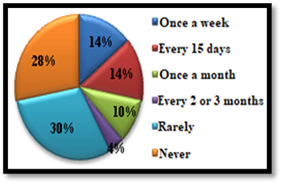
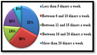
Figure 12: Variation in percentages of attendance (left) and leisure budget per week
by visitors (right) of El Hmeda Park, Tunisia
Figure 13 shows that 60% of visitors find the park
to be a great place to relax, and 32% see it as useful for hiking and some
sporting activities. Only 8% of visitors use the park for its calm. Thus, the
totality of the surveyed visitors considered that the main asset of the park is
the nature and that the lack of security represents the most important
constraint. Regarding the question on the facilities proposed by the visitors
within the park: 25% of the visitors claim the importance of the presence of a
playground for child, 22% a course of health and 20% a restaurant cafe. The
lowest percentages consider the development interest in descending order of
reading, barbecue, picnic and a mini zoo.
|
|
|
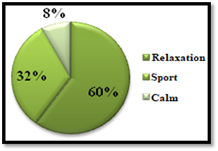
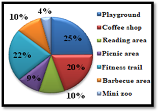
Figure 13: Percent change in visit reasons (left) and planning proposals (right) of
the park "El Hmeda", Tunisia
3.3. CONCEPT REDEVELOPMENT: "THE TREASURE
HUNT"
Table 2 represents a summary of the information retrieved from the study
area to express the strengths and weaknesses of the studied space that can be
used later for the idea of redevelopment. The park to be
redeveloped is a natural urban park, located on a hill, offering a panoramic view
of the entire city of Ksour Essef. It has a very large area, with unevenness
and differences in slopes presented in the form of paths that snake. Thus, the
relief is not very marked, ruiniform because of the calcareous texture of the
soil. The rocks are sharp by the slow persistent erosion caused by water and
wind. This natural park is marked by the afforestation of "Pinus
halepensis" with isolated silhouettes and the grouping of groves gives
it a dark green color especially in the northern part. However, this mass of
pines encloses the views close by closing the landscape and hides the distant
views. The elevation of the park represents the main element in the structuring
of the space, it is the point on which will be based all the proposal of the
development. However, the park suffers from some constraints that must be
solved to achieve the proposed development. These obstacles include lack of
water points and lack of security.
Table 2: Assessment of the landscape analysis
|
|
Components |
Assets |
Constraints |
Balance
sheet |
|
Physical study |
Area |
Important |
- |
Diversity
of development |
|
Elevation |
Panoramic
view |
- |
Valuing the
upper part |
|
|
Hydrographic
network |
- |
Lack of
water source |
Dig a
survey |
|
|
Isohumic
and rocky soil |
- |
Erosion
problem |
Reforestation |
|
|
Vegetation |
« Pinus Halepensis » |
Degraded
state |
Diversification
of the plant palette |
|
|
Sensitive study |
Opening |
Large space |
Security
problem |
Delimitation
of space by a fence |
|
Verticality |
- |
Dead view |
Using
flexible forms |
|
|
Colors |
Nature |
Absence de diversity et vivacity |
Insertion
of colored elements |
|
|
Rough
terrain |
Dynamism |
Difficulty
of movement |
Smooth the
trails |
|
|
Difference
of levels |
Leveled
space |
Some hidden
views |
Valorization |
|
|
Sound and
noise |
Sound of
birds and tree leaves |
Noise
pollution of roads |
Sound
barrier |
|
|
Anthropic
study |
Age groups |
Profiles
diversity |
- |
Propose a
more attractive redevelopment |
|
Sex |
||||
|
Origin |
- |
Limits of frequentation |
||
|
Relaxation
budget |
- |
Low |
||
|
Distance |
Most
visitors are not far from the park |
Unknown
space |
||
|
Frequency
of visit |
- |
Rare |
||
|
Main raison
for visits |
Relaxation
in nature |
- |
The proposed concept aims to enhance the strengths of space created by
nature and based on its physical criterion, mainly its altitude difference.
Thus, three levels of development will be presented giving the impression of a
treasure hunt adventure where in each part a different atmosphere will be
discovered: i) the first is characterized by a flat earth and a very Aleppo
pine wood. dense, ii) the second has a resting family space and iii) the third
is characterized by a panoramic view open to the whole city. The main objective
of this redevelopment is the sustainability of the space, while seeking to
promote the meeting of people and the practice of sports activities, thus
reducing stress and improving the health of visitors. The environmental aspect
is reflected in the use of wood in the majority of furniture, and the
densification and variation of plants to create a green lung and improve the
living environment of the population. Finally, the development of the economic
aspect will be favored by the inclusion of refreshments and games.
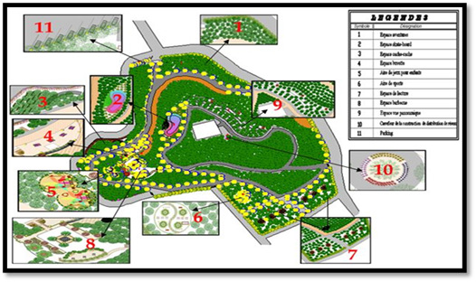
Figure
14: Redevelopment plan for El Hmeda Park, Ksour Essef, Tunisia, presenting 11
entities: (1) Adventure area - (2) Skateboard space - (3) Hide-and-seek area -
(4) Bar area - (5) Children's play area - (6) Sports area - (7) Reading area -
(8) BBQ area - (9) Panoramic view area - (10) Crossroads of network
distribution construction and (11) Car park
3.4. THE PROPOSED SUSTAINABLE PLANNING
Entity 1: The Adventure area presents the
first component of the first treasure "adventure in good health"; it
is a kind of game: climbing trees since this part has a very high density of
"Pinus halepensis" which helps the implementation of furniture of
this game. Upon entry a sign, containing the necessary information (presentation
of the game, how to play and ages of users), is put to give a general idea
about the activity to be done. This game is a kind of wooden cylinders fixed on
tree trunks connected together by ropes and nets must be climbed. Benches and
bins are scattered on both sides and candelabra installed to ensure the use of
space during the night. In addition, a fence followed by an alignment of
"Acacia dilbata" proposed for more security.
Entity 2: The
Skateboard space presents
the second component of the first treasure. It consists of a large skateboard
stage and a climbing game built on a natural rock. This part begins with a sign
giving information on the activities that are dedicated for young people
(skateboarding scene) and for children between 6 and 12 years old (climbing
game). The vegetation is very simple composed of "Pinus halepensis"
with 22 "Pinus pinea", without forgetting the benches and lighting.
Entity 3: The
Hide and Seek Space are dedicated for children between 3 and 12 years old.
It is built of a set of wooden plates pinted in red constituting the game of
hide and seek and a net for the activity of the climb. This part of the park is
suitable for this type of activity thanks to the high density of "Pinus
halepensis". Thus, a fence protects her, hidden by a red and mauve
Bouganvillea glabra gardener, and accompanied by a wooden bench and
candelabra for the light.
Entity 4: The refreshment Bar area room presents the
fourth component of the first "adventure in good health" treasure. It
is a forest-style space marked by an artificial waterfall, located on a natural
rock, led by a floral flower planter composed of "Antirrhuim majus",
"Lathyrus adoratus", and "Tagetes patula" lit by recessed
floors colored. Four wooden pergolas planted around the bar, covered by
"Bougainvillea glabra" and lit by colored markers.
Entity 5: The
Children’s play area is a playground dedicated for children from three to 10 years old. It filled
with toboggans, swings, and nets for climbing activity. The lining of this
space is made of colored clay in semi-circular shapes, in harmony with the
general shape of the entity. A border in «Pelargonium peltatum» and colored
markers to give more atmosphere marks the route.
Entity 6: the
Sports area is he first terrace
of the space is flat; it presents the ideal location for the establishment of a
practice area of warm-up exercises. Indeed, she is busy with a
few activities, made of wood, such as extension arm beams, horizontal floor
abs, foot-joint jumps, and nets for climbing activity. The fence protecting the
park on this side accompanied by an alignment of "Acacia dilbata".
The layout of this entity marked by a border of "Rosmarinus
officinalis" and recessed floors shaped "Yin Yang" with four
"Salix babylonica" creating a "Zen" atmosphere giving a
feeling of relaxation and joy. Planting holes of "Salix babylonica",
covered with wood, used as benches.
Entity 7: The
Reading Space is dedicated to the students of the college of which it is
composed of six wooden kiosks, an afforestation of "Pinus Halepensis"
and secured by a concealed fence in "Acacia dilbata".
Entity 8: In
the BBQ area, two
rock corners are proposed and made up of "Agave americana
'Marjinata'", "Crasula tetragona", "Grenovia aurea",
"Sansevieria" and "Yucca gloriosa", delimiting the path of
passage to the second treasure "Family and history". By lying at the
barbecue area, a chessboard in the center attracts attention. It surrounded by
a set of wooden balances with, at the corners, planting holes, including a
wooden bench and ¾ for planting four "Elaeagnus angustifolia". The
space provided on an altitude of 50 m, which offers a pleasant open view, for
this reason it is converted into a barbecue area. On the right side of the
chessboard, four tables in natural stones with a parasol in the center of each
arranged. On the left side we have the same design but two barbecues «Lantana
Camara» surrounds areas (a round table and 6 rectangular barbecues). The tables
accompanied by a planter in "Zinnia elegans" and flowerbeds. A
Roman-style corner, surrounded above by "Plumpago capensis", below by
"Gynerium argentum", is implanted to give a historical aspect to the
entity, and presents the historical identity of the city of Ksour Essef through
beams from Roman times and three mosaic paintings.
Entity 9: The Panoramic View Area brings us to the third terrace and
the third treasure "dream and hope". In this part, the altitude
reaches 65 m offering a panoramic view open on all sides, for this reason, the
idea of development was to install three wooden watchtowers
occupied telescopes to give users the chance to live the adventure from hunting
to great treasure. Thus, soil-fixing works take place in this part of the park,
playing the protective role of the soil and a bench for the users.
Entity 10:
The Network Distribution Construction Crossroads is centered on an "Elaeagus
angustifolia", and surrounded by four planters of "Petunia
hybrida" of four colors.
Entity 11:
The parking is
arranged in 45 ° to increase the number of places and for the shade, the
"Ficus nitida" be used.
4.
DISCUSSION
The
cities peri-urban green lung parks represent the new tools of spatial planning;
they are also green infrastructures that contribute to the organisation of the
hinterland of the new urban areas. Here the peri-urban park of ksour essef,
shows well following a geographical evaluation of its natural resources, as
well as a landscape diagnosis based on spatial, sensitive and social aspects,
it was possible to show that despite the constraints and threats that hinder
the development of this park on different levels (social, environmental and
economic), there is a remarkable natural wealth, a sensitivity of citizens to
the importance of this space in improving their living environment, as well as
the awareness of local authorities (municipality of Ksour Essef) of the
importance of this park in the development of the city and also in the
enhancement of the urban environment and in the preservation of nature and its
biodiversity. The concept of "treasure hunt" is a guiding idea that
respects the environmental conditions, the needs of the population concerned by
the park's redevelopment project and the requirements of sustainable
development. The objective was to encourage residents of different age groups
to discover this natural space in a way that promotes the link between natural
and urban.
5.
CONCLUSION
Combining
the management of sensitive areas with landscape analysis is an important
discovery, analysis and decision-making process for sustainable landscape
management. By protecting and managing natural and public lands in an
environementally sensitive manner will help decision makers. The conservation
of a peri-urban forest and its environmental managment makes it possible to
remedy the negative impacts of anthropogenic events (deforestation, fires, urbanization,).
These natural spaces converted into public parks offer services for society and
improve the urban environment. However, this ecological development consists of
ensuring visitors to the El Hmeda Forest Park the practice of sports activities
in the natural environment to maintain good health, escape from a sedentary
lifestyle and protect against several diseases threatening people in cites.
SOURCES OF FUNDING
This research received no specific grant from any funding agency in the public, commercial, or not-for-profit sectors.
CONFLICT OF INTEREST
The author have declared that no competing interests exist.
ACKNOWLEDGMENT
None.
REFERENCES
[1] Papillon P., 2014, Les forêts
périurbaines : des espaces récréatifs à la fonction prophylactique : le cas des
aires urbaines d’Alençon, de Blois et du Mans. Géographie. Université du Maine.
[2] Pau F J Eagles. 1981. Environementally
Sensitive Area Planning in Ontario, Canada. Journal of the American planning
Association. 47: 313-323
[3] Observatory of the Sahara and
Sahel (OSS) 2003. Map of sensitivity to desertification in the Mediterranean
basin, Proposal for the methodology for the final map, Rome.
[4] Mohamed Cherif, « Dynamique de
l’agriculture périurbaine autour des villes moyennes: l’exemple de la ville de
Mahdia (Tunisie) », Les Cahiers d’Outre-Mer, 263 |
[5] CRDA, 2014. Regional Report of
Mahdia. 70 p
[6] God A, Lotfy I, 2008. Use of
remote sensing and GIS in mapping the environmental sensitivity areas for
desertification of Egyptian territory. Earth Discussion, 3: 41–85
[7] Khebour Allouche Faiza and Gad
Abdallah. 2014. A Comparison of Methods for Mapping the Environmental Sensitivity
Areas for Desertification of a Mediterranean Landscape Using Remote Sensing and
GIS Applications. European Academic Research. Vol II. Issue 8.
|
|
 This work is licensed under a: Creative Commons Attribution 4.0 International License
© Granthaalayah 2014-2020. All Rights Reserved.