
|
|
|
|
CLASSIFICATION AND MAPPING OF LAND USE AND SOME SOIL PROPERTIES IN KIRŞEHIR PROVINCE, TURKEYM. Cüneyt Bağdatlı 1 1 Nevsehir Hacı Bektas Veli University, Engineering and Architecture Faculty, Department of Biosystem Engineering, Nevsehir, Turkey.2 Nevsehir Hacı Bektas Veli University, Science Institute, Department of Environmental Engineering, Nevsehir, Turkey. |
|
||
|
|
|||
|
Received 21 July 2021 Accepted 01 August2021 Published 31 August 2021 Corresponding Author M.
Cüneyt Bağdatlı, cuneytbagdatli@gmail.com DOI 10.29121/ijetmr.v8.i8.2021.1022 Funding:
This
research received no specific grant from any funding agency in the public,
commercial, or not-for-profit sectors. Copyright:
© 2021
The Author(s). This is an open access article distributed under the terms of
the Creative Commons Attribution License, which permits unrestricted use, distribution,
and reproduction in any medium, provided the original author and source are
credited.
|
ABSTRACT |
|
|
|
In this
study, land use capabilities, land types and other soil properties of
Kırşehir province were classified and analyzed. In the study, 1/25.000
scale digital soil maps obtained from the Ministry of Agriculture and
Forestry (Turkey) were used. Numerical data were classified using Arc GIS
10.3.1 software, which is one of the GIS software. As a result of the
research; In general, It was observed that IV. class lands were formed in the
Kirsehir province IV.class lands were found to be 1658.3 km2 and
it was determined that they cover 25% of the total area. It is seen that soil
insufficiency is high in Kırşehir province due to slope and erosion
damage. Soil insufficiency due to slope and erosion damage was found to be
3520.7 km2 and it was determined that 54% of the total area was
exposed to this effect. It has been observed that the land type is generally
composed of steppe, bare rocks and rubble. It was determined that the area
formed by bare, rocks and debris is 1128.5 km2. It has been
determined that the stony soil areas are 1094.2 km2. As a result
of the study, classified map outputs related to land uses and some soil
properties were obtained. It will be inevitable that this research will
provide important database bases for other studies to be carried out in this
region in the future. |
|
||
|
Keywords: Land Use Capabilities, Soil Properties, Classification, GIS Mapping, Kırşehir Province, Turkey 1. INTRODUTION Water and soil, which
are the main factors in the development of societies, which people have been
fighting for ages to find, also caused the collapse and disappearance of many
civilizations in the past. Soil is a three-dimensional living entity that covers
the outside of the supply, consists of a mixture of various decomposition
products of rocks and organic materials, contains a wide world of living
things inside and on it, is a stopping place and food source for plants, and
contains water and air in certain proportions (Akalan (1977). Soil is a resource that
takes centuries to form and is impossible to produce. According to Bozyiğit (2020), soil formation
is an important part of the stony sphere, which gains importance day by day
with its properties, use and protection. Soil is an environment that
nourishes and hosts the living things living on and in it, thanks to the
nutrients it contains and the cycle of substances that enable the reproduction
of these nutrients. |
|
||


Water and food are an
indispensable source of life for all living things. It has been effective in
the settlement in terms of agriculture and life source of civilizations from
past to present. Therefore, it is important to protect soil resources.
The most important issue
in the protection of soil resources potential is to determine the current
situation and to determine the attitudes towards forward projection and to put
forward the measures that can be taken (Bağdatlı et al. (2014).
The rapid increase in
the population in the world and in our country has been effective in the
increase in consumption and the development of the industry. This increase and
consumption has been effective in the wrong and unconscious use of natural
resources. Since the agricultural sector constitutes approximately 15% of national
income, 45% of employment and 14% of exports, it is a social sector as well as
an economic one (Tekinel (2004). This rapid increase and the increase in the need for
agricultural products, the acceleration of soil erosion as a result of the
destruction of forests, the deterioration of hydraulic conditions, the
expansion of agricultural areas to the detriment of natural plant communities,
excessive grazing, changes in agricultural methods and technology, especially
the use of artificial fertilizers and pesticides. The reasons such as the fact
that it has been used to a large extent have led to serious deterioration and
pollution in the soil ecosystem in many countries (Sönmez (1995). Accordingly, global climate change and global
warming also affect the soil structure. As a result of global warming,
excessive carbon emissions into the atmosphere and the mixing of toxic gases
and precipitation in the form of acid rain affect the soil and plant structure.
Especially as a result of acid rains, pH changes will occur in the soil. In
addition, increasing urbanization, the increase in the use of pesticides, solid
wastes change the soil structure, but also affect the water quality of the
underground water resources and the existing water source by infiltration. For
this reason, the sustainability of existing soil and water resources is an
important factor. For this, detailed soil survey and mapping studies are of
great importance in the sustainable use of soil and water resources, in future
planning (Anderson et al. (1976).
Soil maps produced as a
result of soil survey and mapping studies and related reports form a soil
database for users. This database is used in agricultural planning, modeling of
environmental impacts, in various engineering branches and in planning and
protection of natural resources (Dengiz and Sarıoğlu (2011).
Currently, the existing
database on soil resources in our country is based on the soil surveys
conducted between 1966-1971. The most qualified research on Turkey's soils to
determine soil quality and fertility is the "Turkey Soil Productivity
Inventory Project (TOVEP)" conducted by General Directorate of Village
Services in Turkey (Karaca et al. (2019).
Within the scope of this
project, the nitrogen, phosphorus and potassium status of the soils, which are
the basic plant nutrients, and the organic matter, pH, lime status and texture
classes of the soils were examined, and the results were published under the
name of "Provincial Fertility Inventory and Fertilizer Needs Reports"
with 1/100.000 scale maps. (Özyazıcı et al. (2014).Geography Information Systems (GIS) has an important
place in digitizing maps. According to Başyiğit et al. (2008), Geography information systems are capable of
displaying the spatial information of the collected data, using graphics and
quality information simultaneously, contributing to the solution of management,
planning and analysis problems by integrating data from different information
sources, providing standardization in information exchange and combining maps
and tables . It will also be effective in using soil data in agricultural
production.
Specially in
agricultural production, plant pattern estimation in agriculture, yield
estimation, determination of meadow and pasture areas, determination of fallow
areas, monitoring of plant development, soil classification, irrigation and
drainage studies, water resources protection planning, resource estimations
related to agriculture and animal husbandry, determination of rural settlements
GIS can be used for many agricultural purposes such as (Delibaş et al. (2015).
According to Kılıç et al. (2017), agricultural production, which has a great
importance especially in the country's economy, it is thought that the
efficiency of plant production will increase with soil maps created and
appropriate management plans and fertilization in areas where agricultural
production is made.
In this context, by
using Arc GIS 10.3.1 software, the digital soil maps of the land and soil
characteristics of Kırşehir province were classified by layering the
soil map, and the land use capability classes, land use capability subclasses,
land types and other soil characteristics related to the study area. has been
revealed. In this way, by sharing the research results, it will make important
contributions to the investor organizations that will invest in the region and
contribute to agricultural production.
2. MATERIAL and METHOD
This study was carried
out in the province of Kırşehir, which is located in the Central
Anatolia region in Turkey. Kırşehir province is located in the
Central Kızılırmak Section of the Central Anatolia Region. The
location of the province is between 38º50' -39º50' north latitudes and 33º30'
-34º50' east longitudes, and it is between Nevşehir, Aksaray,
Kırıkkale, Yozgat and Ankara and neighboring province borders (Kıymaz (2011).
Kırşehir has a
continental climate with cold and snowy winters and hot and dry summers.
Kırşehir has a semi-arid climate. The annual average temperature in
the province is 11.3 °C, and the annual precipitation is less than 400 mm (Anonymous (2008). There are a total of 6 districts and 189 villages in
Kırşehir province (Anonymous (2020). It has a surface area of 6570 km2 and
its height from the sea is 985 m. The breadth of the province's territory is 8
per thousand of the country's territory, and 2.9% of the Central Anatolian
Region. (Anonymous (2008). Kırşehir province has 657679 hectares of
land. Of these lands, 454720 hectares (69.14%) are arable land, 132450 hectares
(20.16%) are meadow-pasture, 25063 hectares (3.74%) are forests and nurseries,
45446 hectares (6.96%) are unsuitable for agriculture (Anonymous (2007).
It has been determined
that 366222 hectares of the 454720 hectares of agricultural land in
Kırşehir province is irrigable. In short, although 80.4% of the
agricultural land is irrigable, only 6.84% can be irrigated. This indicates the
importance of irrigation in our city, where the annual precipitation is around
250-500 mm, but clearly shows the inadequacy in this area (Kıymaz (2011). The location and location of Kırşehir
province, which is the subject of the research, can be seen on the map given in
Figure 1.
|
|
|
Figure 1 Location of
the Research Area |

In this study, land use
capability classes, land use capability subclasses, land types and other soil
properties were classified by using 1/25.000 scaled digital soil maps of
Kırşehir province. In this study, digitized 1/25.000 scaled soil maps
of Kırşehir province obtained from the Ministry of Agriculture and
Forestry were used (Anonymous (2000).
Numerical data were
classified as layers using Arc GIS 10.3.1 software (Anonymous, (2010). The classified soil maps obtained were evaluated
according to the "Soil and Land Classification Standards Technical
Instruction" published in 2005 by the Turkey Ministry of Agriculture and
Rural Affairs (Anonymous, (2005). The flow chart of the methodology applied in the
study is given in Figure 2.
|
|
|
Figure 2 Flow Chart of
the Methodology Applied in the Study |

Land use capabilities
are first class, which can be cultivated in the best, easiest and most
economical way without causing erosion. they are among the eighth grade that
can be used as a park (Anonymous, (2005). The land use capability classes and explanations
used in classification processes are shown in Table 1.
|
Table 1 Land Use Capability Classes (Anonymous, (2005) |
|
|
Land
Use Capability Classes |
Explanations |
|
I. Class |
It is a land containing flat or
nearly flat, deep, fertile and easily cultivable soils where conventional
agricultural methods can be applied. First lands irrigated in places where
there is little rainfall are those that have less than 1% slope, deep, loamy
structure, good water holding capacity, moderately permeable soils. |
|
II. Class |
The differences of this from
first-class terrain may be one or more of the limiting factors, such as mild
inclination, moderate erosion exposure, moderately thick soil, occasional
moderate flooding and moderate wetness that can be easily isolated. |
|
III. Class |
Moderate tendency, sensitivity
to erosion, excessive wetness, shallow soil, presence of base stone, excess
sandiness or graveliness, low water holding capacity and low productivity are
the properties of this class. |
|
IV. Class |
Especially land suitable for
permanent allocation to the meadow |
|
V. Class |
Since it is not suitable for
cultivation, it is allocated to long-lived plants such as meadows and
forests. One or more factors prevent cultivation, stoniness and wetness.
Grazing and cutting of trees are done with the condition of maintaining a
good ground cover. |
|
VI. Class |
It is a land that requires
moderate measures even when used as a forest or a meadow. It is very inclined
and exposed to severe erosion. |
|
VII. Class |
It is very inclined, eroded,
stony and defective, and includes shallow, dry, marshy or some other
unfavorable soils. It can be used as a meadow or a forest provided that much attention
is paid. If the vegetation on it decreases, erosion becomes very severe. |
|
VIII. Class |
It contains features that
prevent cultivation and use as meadow or forest. These include marshland,
desert, terrains containing very deep cavities, and high mountainous, overly
defective, stony lands. |
The existing negative
impacts on the land of the subclass of land use capability, which is below the
land use capability, are classified. The classification was evaluated as slope
and erosion damage, soil insufficiency, stony, drainage disorder and flood
damage and climate limitations.
Land types have been
revealed according to the physical structure of the land. In addition, other
soil properties and physical factors of soil structure were evaluated. The layers
used in the evaluation and classification are shown in Table 2, Table 3.
|
Table 2 Classification
of Land Types (Anonymous, 2005) |
|
Land Types |
|
Naked Rock and Rubble |
|
River Flood Beds |
|
Coastal Dunes |
|
Black Dunes |
|
Reeds |
|
Lands Covered with Permanent Snow |
|
Table 3 Classes of Other Soil Properties
(Anonymous, 2005) |
|
|
Other Soil Properties |
|
|
Slightly Salty |
Stony |
|
Salty |
Rocky |
|
Alkali |
Poorly Drained |
|
Slightly Salty-Alkali |
Bad Drained |
|
Salty-Alkali |
|
3.
RESEARCH FINDINGS
3.1. Spatial Analysis of Land Use Capabilities
The 1/25.000 scale
digital soil maps of Kırşehir province were classified using Arc GIS
10.3.1 software and the Spatial Analysis of Land Use Capabilities map of the
study area is given in Figure 3.
|
|
|
Figure 3 Spatial Analysis of Land Use
Capabilities |
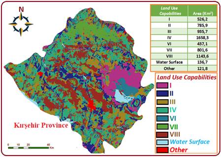
Covering the largest
area in Kırşehir province, IV. class lands and the total area covered
by these lands is 1658.3 km2. These lands correspond to 25% of the
total area.
IV. Class land is the
land class that is particularly suitable for permanent allocation to pasture.
Occasional field crops may also be grown. Excessive slope, erosion, bad soil
characteristics and climate are the limiting factors for agriculture to be made
on this class of soil. It is poorly drained soils with poor drainage. They are
not subject to erosion, but they are not suitable for growing many crops
because they dry out suddenly in the spring and their productivity is low. In
semi-arid regions, it is generally not possible to apply rotation systems
containing legumes on fourth class lands due to climate (Anonymous, 2005).
I. Class lands are 526.2
km2, II. Class lands cover an area of 785.9 km2.
First class land; It is a land containing flat or nearly flat, deep, fertile
and easily cultivated soils where conventional agricultural methods can be
applied. There may be little water and wind erosion on this class of land.
Soils have good drainage and are not subject to flood damage. They are suitable
for hoe plants and other intensively grown crops. I. class lands irrigated in
places with low rainfall are lands with less than 1% inclination, deep, loamy
structure, good water holding capacity, moderately permeable soils (Anonymous,
2005).
II. class land is good
land that can be easily cultivated only by taking some special precautions.
Differences from first class land may be one or more of the limiting factors
such as light inclination, moderate erosion, moderately thick soil, occasional
moderate flooding, and moderate wetness that can be easily isolated (Anonymous,
2005). .
3.2. Spatial Analysis of Land Use Capability
Subclasses
1/25.000 scaled digital
soil maps of Kırşehir province were classified using Arc GIS 10.3.1
software and spatial analysis of Land Use Capability Subclasses are given in Figure 4 as map output.
|
|
|
Figure 4 Spatial
Analysis of Land Use Capabilities Subclasses |

In Kırşehir
province, there is a general lack of soil, slope and erosion damages. Soil
insufficiency, slope and erosion damage constitute 54% of the total area with
an area of 3520.7 km2. Only slope and erosion damage has an area of
723.6 km2, which corresponds to 11% of the total area.
In general, it is
observed that soil insufficiency and slope and erosion damage are high in
Kırşehir province. It has been determined that there are areas with
lump deficiency in an area of 51.5 km2 in the study area.
3.3. Spatial Analysis of Land Types
Kırşehir
province was analyzed as a research area as a result of classification made
with the help of Arc GIS 10.3.1 software using 1/25.000 scaled digital soil
maps and the results are given in Figure 5.
|
|
|
Figure 5 Spatial
Analysis of Land Types |

As a result of the data
obtained from the current land type of Kırşehir province, the data
were classified using Arc GIS 10.3.1 software and a map was created. As a
result of this map created, the current surface area of Kırşehir
province was determined as 6547 km2. In addition, it is observed
that most of the existing land type of Kırşehir province consists of
bare rocks and rubble. Bare and rubble areas have an area of 1128.5 km2.
It constitutes 17% of the total area. In addition, it is concluded that other
(settlement, industry, water surface, etc.) areas on the map created have an
area of 5403.4 km2 (Anonymous, (2005).
3.4. Spatial Analysis of Other Soil Properties
Spatial
Analysis of the other soil properties created using Arc GIS 10.3.1 software of 1/25.000 scaled digital soil maps
of Kırşehir province is given in Figure 6.
|
|
|
Figure 6 Spatial
Analysis of Other Soil Properties |
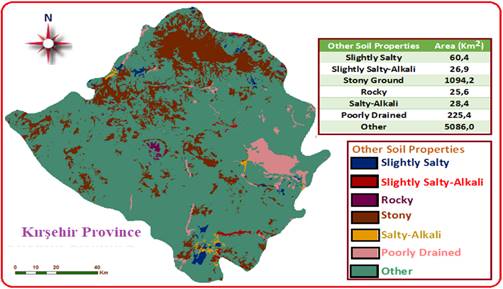
Most of the soil
properties of Kırşehir province consist of stony areas. The stony
areas are mostly seen in the northern part of the province. As a result of the
analysis, the stony area was found to be 1094.2 km2. This situation
constitutes 17% of the total area. Along with stony areas, 225.4 km2
was found in areas with insufficient drainage and it was determined that it
corresponds to 3% of the total area. Excessive stonyness is seen as erosion
damage. This situation will be especially effective in the emergence of
restrictions in agricultural production.
4.
CONCLUSION and
RECOMMENDATIONS
Today, the population is
increasing rapidly. Negative effects occur in parallel with the rapidly
increasing population. These negative effects directly affect the basic
elements necessary for vital activities and the importance of these elements is
increasing day by day. These effects also negatively affect the soil. In terms
of soil characteristics, the region where they are located bears traces
according to the geographical structure. Therefore, soil features have
different regional traces and it is important to map an area in order to
comment on it. Today, digital maps are of great importance in the creation of
soil maps. Geography Information Systems are of great importance in the
creation of digital maps.
GIS is a system consisting
of hardware, software, methods and personnel working for this purpose, covering
the modeling, processing, analysis, presentation according to the purpose of
use, in short, the data used in planning and management (Uzun (2012).
There are different
methods in the creation of soil maps in the world and in our country. Soil
surveys have been completed in all agricultural areas in the USA, 91% of
private areas and 76% for the whole country. Published reports are generally in
the scale of 1:15,840 or 1:24,000 and contain quite comprehensive information.
There is a similar situation in European countries (Bathgate and Duram (2003).
Mapping studies in
Turkey were given to the General Directorate of Soil-Water with the law
numbered 7457, which entered into force on 28.02.1960. After that, the General
Directorate of Soil-Water took over the task of creating maps by classifying
the lands of Turkey and coordinating the studies carried out at the country
level on this subject, and the General Directorate of Rural Services with the
abolition of this directorate.
By the General
Directorate of Soil and Water, the entire country's lands were examined and
mapped between 1966-1971 using 1/25.000 scale topographic maps. Only soil
depth, slope, degree of erosion, drainage, salinity, alkalinity, stony, rocky,
land use capability class, subclass and land use status can be obtained from
these maps (Dengiz and Sarıoğlu (2011). According to Akbaş
and Yıdız (2004), they stated that these maps could not be used in detailed studies and
plans because the information they provided was not sufficient and up-to-date.
These maps created an important basis for data acquisition in Geography
Information Systems (GIS).
Digitization of maps is
of great importance in Geography Information Systems. It provides
classification of information, predicts results from objects and events, and
stands out in strategic planning by using databases for query purposes and
statistical analysis with the help of digital smart maps. (Yomralıoğlu (2000), Akbaş et al.
(2008). The maps produced by digitizing the maps are used as
a base. Various GIS programs are used to digitize maps.
It is important to
establish the existing land use plans of the regions. Land Use Plans; Based on
soil and land surveys, local, regional and national scale agricultural, forest
and pasture lands, lands limited by special law, industrial housing and tourism
areas, infrastructure areas for economic and social purposes, different land
use types and current use types and sustainable land They are the plans created
from maps and reports showing the management styles (Akten (2008). Digitization of topographic maps is of great
importance in the creation of land use plans.
As a result of this
study, the land use capabilities of Kırşehir province and some soil
properties were classified using Arc GIS 10.3.1 software and the analysis
results were shared as map outputs. In the study, stratified classifications of
1/25.000 scaled digital maps obtained from the Ministry of Agriculture and
Forestry were made using Arc GIS 10.3.1 software. In classification, land use
capability classes, land use capability subclasses, land types and other soil
properties were analyzed. The maps obtained were evaluated according to the
"Soil and Land Classification Standards Technical Instruction" published
by the Ministry of Agriculture and Rural Affairs (Turkey) in 2005. The land use
potential of Kırşehir province is shown in Figure 7.
|
|
|
Figure 7 Land Use
Capabilities and Other Properties of Kırşehir Province |

The land use
capabilities of Kırşehir province were analyzed and classified in 9
categories. According to the classification made, the largest area is 1658.3 km2,
IV. class lands were observed. The fourth class lands constitute arable lands
with tillage. Class I land 526.2 km2, II. class land, 785.9 km2,
III. class land 935.7 km2, VI. class land 437.1 km2, VII.
class land 801.6 km2, VIII. class land was found to be 1143.6 km2.
For this reason, according to the total area IV. class land to 25% of the total
area, VIII. 18% of class land, III. Class Agricultural land is 14%, VII class
land is 12%, and the remaining 30% is other land classes. In general, 18% of
the territory of Kırşehir province is unsuitable for agriculture.
Although 59% of the rest is agricultural land suitable for tillage agriculture,
23% of it consists of lands unsuitable for tillage agriculture.
When the land use
subclass of Kırşehir province is examined, it is concluded that the
soil insufficiency due to slope and erosion damage is quite high. Soil
insufficiency due to slope and erosion damage was found to be 3520.7 km2.
54% of the total area was exposed to this effect due to soil insufficiency due to
slope and erosion damage. When the current land type is examined, it is
concluded that 1128.5 km2 area consists of bare rocks and rubble. In
addition, when the other soil characteristics were examined, it was concluded
that 1094.2 km2 area was stony soil.
In this study, the soil
potential of Kırşehir province was tried to be determined by using
the Geography Information Systems. According to Kıymaz
(2011) it has been determined that there has been no
previous study on soil structure, recreation and general soil structure such as
total salt, lime and organic matter amount in Kırşehir province. For
this reason, in the light of the data obtained, it will be inevitable that this
study will provide infrastructure support to the investor institutions in the
region. This study will be a guide for similar studies by transferring it to
users in the digital environment and creating a database, thus setting a precedent
for the study.
REFERENCES
Akbaş and Yıdız, H. (2004). Toprak Özelliklerinin Haritalanmasında Jeoistatistiksel Tekniklerin Kullanılması, 3. Coğrafi Bilgi Sistemleri Bilişim Günleri, 6-9 Ekim, Türkiye. (in Turkish)
Akten M. (2008). Isparta Ovasının Optimal Alan Kullanım Planlaması Üzerine Bir Araştırma, Süleyman Demirel Üniversitesi, Fen Bilimleri Enstitüsü, Orman Mühendisliği Anabilim Dalı, Doktora Tezi, Isparta, (in Turkish)
Akbaş, F, Ünlükara, A., Kurunç, A., İpek, U., & Yıldız, H. (2008). Tokat Kazova’da Taban Suyu Gözlemlerinin CBS Yöntemleriyle Yapılması ve Yorumlanması. Sulama ve Tuzlanma Konferansı, 12-13 Haziran 2008, Şanlıurfa. Retrieved from https://avesis.erciyes.edu.tr/yayin/173ac851-6a1e-4794-9593-a39cc91d3a97/tokat-kazovada-taban-suyu-gozlemlerinin-cbs-yontemleriyle-yapilmasi-ve-yorumlanmasi
Anderson, J. R. E. E., Hardy J. T., Roach & R.E. Witmer., (1976). A Land Use and Land Cover Classification System for Use with Remote Sensor Data. U.S. Geological Survey, Professional Paper 964, pp 28, Reston, VA Retrieved from https://doi.org/10.3133/pp964
Anonymous, (2005). Toprak ve Arazi Sınıflaması Standartları Teknik Talimatı, Retrieved from https://www.mevzuat.gov.tr/MevzuatMetin/1.5.5403.pdf (Access Date: 16.04.2020) (in Turkish)
Anonymous, (2000). Sayısal Toprak Haritaları, Mülga Köy Hizmetleri Genel Müdürlüğü, Ankara (in Turkish)
Anonymous, (2007). Kırşehir Tarım İl Müdürlüğü Kayıtları, Kırşehir (in Turkish)
Anonymous, (2008). Kırşehir İl Çevre Durum Raporu. Kırşehir Valiliği İl Çevre ve Orman Müdürlüğü, Kırşehir (in Turkish)
Anonymous, (2020). Kırşehir hakkında genel bilgiler, Kırşehir İl Kültür ve Turizm Müdürlüğü Retrieved from https://kirsehir.ktb.gov.tr/TR-64747/genel-bilgiler.html (Access Date: 16.04.2020) (in Turkish)
Anonymous, (2010). Arc GIS 10.3.1. ESRI Environmental System Research Institute. Redland, CA, USA
Akalan, İ. (1977). Toprak Oluşu, Yapısı ve Özellikleri, Ankara Üniversitesi, Ziraat Fakültesi Yayınları, No: 662/204 (in Turkish)
Bağdatlı, M.C., İstanbulluoğlu, A., & Bayar, N.A. (2014). Toprak ve Su Kaynakları Potansiyelinin Coğrafi Bilgi Sistemleri (CBS) Yardımıyla Belirlenmesi: Tekirdağ-Çerkezköy İlçesi Uygulaması, Afyon Kocatepe Üniversitesi, Fen ve Mühendislik Dergisi, Sayı:14, 17-25, Afyon (in Turkish) Retrieved from https://doi.org/10.5578/fmbd.6760
Bathgate, J.D., & Duram, L.A. (2003). A Geographic Information Systems Based Landscape Classification Models to Enhance Soil Survey: A Southern Illionis Case Study. Jour. Of Soil and Water Cons. 58:119-127 Retrieved from https://www.jswconline.org/content/58/3/119.short
Başyiğit, L., Şenol, H., & Müjdeci, M. (2008). Isparta İli Meyve Yetiştirme Potansiyeli Yüksek Alanların Bazı Toprak Özelliklerinin Coğrafi Bilgi Sistemleri ile Haritalanması, Süleyman Demirel Üniversitesi Ziraat Fakültesi Dergisi 3(2): 1-10, ISSN 1304-9984 (in Turkish) Retrieved from https://dergipark.org.tr/en/pub/sduzfd/issue/50301/317600
Bozyiğit, R. (2020). Seydikemer İlçesi (Muğla) Topraklarının Özellikleri ve Kullanımı Üzerine Bir Değerlendirme, Avrupa Bilim ve Teknoloji Dergisi, 18:695-706. (in Turkish) Retrieved from https://doi.org/10.31590/ejosat.702654
Delibaş, L., Bağdatlı, M.C., & Danışman, A. (2015). Topoğrafya ve Bazı Toprak Özelliklerinin Coğrafi Bilgi Sistemleri (CBS) Ortamında Analiz Edilerek Ceviz Yetiştiriciliğine Uygun Alanların Belirlenmesi: Tekirdağ İli Merkez Köyleri Örneği, GÜFBED/GUSTIJ 5 (1): 50-59 (in Turkish) Retrieved from https://doi.org/10.17714/gufbed.2015.05.004
Dengiz, O., & Sarıoğlu, F.E. (2011). Samsun İlinin Potansiyel Tarım alanlarının Genel Dağılımları ve Toprak Etüd ve Haritalandırma Çalışmalarının Önemi, Anadolu Tarım Bilim. Dergisi,26(3):241-250 (in Turkish) Retrieved from https://dergipark.org.tr/en/pub/omuanajas/issue/20210/214085
Karaca, S., Sarğın, B., & Türkmen, F. (2019). Bazı Arazi ve Toprak Niteliklerinin Coğrafi Bilgi Sistem Analizleriyle İncelenmesi: Van İli Arazi ve Toprak Özellikleri, Türkiye Tarımsal Araştırmalar Dergisi, 6(2): 199-205 (in Turkish) Retrieved from https://doi.org/10.19159/tutad.542543
Kılıç, O.M., Polat, F., Buhan, E., & Doğan, H.M. (2017). Zinav Gölü Havzasının Topoğrafik Durumu, Arazi Kullanımı ve Bazı Toprak Özelliklerinin CBS ve UA ile Haritalanması, Gaziosmanpaşa Bilimsel Araştırma Dergisi, 6 (3): 45-54 (in Turkish) Retrieved from https://dergipark.org.tr/en/pub/gbad/issue/31228/331871
Kıymaz, S., (2011). Kırşehir İli Toprak ve Su Kaynaklarının Tarımsal Açıdan Değerlendirilmesi, Süleyman Demirel Üniversitesi Ziraat Fakültesi Dergisi 6 (2):76-85 (in Turkish) Retrieved from https://dergipark.org.tr/en/pub/sduzfd/issue/29598/317560
Özyazıcı, M.A., Dengiz, O., & İmamoğlu, A. (2014). Siirt İli Bazı Arazi ve Toprak Özelliklerinin Coğrafi Bilgi Sistem Analizleriyle Değerlendirilmesi, Türkiye Tarımsal Araştırmalar Dergisi, 1: 128-137 (in Turkish) Retrieved from https://doi.org/10.19159/tutad.67391
Sönmez, K., (1995). Çevre Kirliliği Ders Notları Atatürk Üniv. Ziraat Fak., Erzurum (in Turkish)
Tanrıkulu, M. (2017). Türkiye’de Toprak Etüt-Haritalama Çalışmaları ve Harvey Oakes, Akademik Bakış Dergisi, Sayı: 64 Kasım-Aralık (in Turkish) Retrieved from https://dergipark.org.tr/en/download/article-file/438452
Tekinel, O. (2004). Sulu Tarımında Problemler ve Çözüm Yolları, 21. Yüzyılda Su Sorunu ve Türkiye (Fırsatlar- Zorluklar, Güçlü ve Zayıf Yanlarımız) Konulu Toplantı Kitabı, VAKIF 2000. 2000’li Yıllarda Türkiye Stratejik, Sosyal ve Ekonomik Araştırmalar Vakfı, Şubat 2004, Ankara (in Turkish)
Uzun, N. (2012). Mera Hayvancılığında Uydu Görüntü İşleme Teknikleri ve Coğrafi Bilgi Sistemi Kullanımı, Süleyman Demirel Üniversitesi, Fen Bilimleri Enstitüsü, Zootekni Anabilim Dalı, Yüksek Lisans Tezi (in Turkish)
Yıldız, N. (1996). Tarımsal Faaliyetlerin Etkileri, Atatürk Üniversitesi, Ziraat Fakültesi Dergisi, 27(2): 324-333 (in Turkish)
Yomralıoğlu, T. (2000). Coğrafi Bilgi Sistemleri Temel Kavramlar ve Uygulamalar, İber Ofset, 2. Baskı, Trabzon (in Turkish)
|
|
 This work is licensed under a: Creative Commons Attribution 4.0 International License
© IJETMR 2014-2021. All Rights Reserved.