
SPATIAL EVALUATION OF LAND AND SOIL PROPERTIES IN THE EXAMPLE OF NEVŞEHİR PROVINCE, TURKEY
Abstract
In this study, some land and soil properties were spatially evaluated with the help of 1/25.000 scaled digital soil maps belonging to Center of Nevşehir province in the Central Anatolia Region, Turkey. Land use capability, large soil groups, soil depths, erosion, slope and spatial distributions of current land uses were carried out in the research. Arc GIS 10.3.1 software, which is one of the Geographic Information Systems (GIS) software, was used for spatial analysis. With a maximum of 262518 da in the study area, VI. class lands. Class I lands cover an area of 247 decares. In terms of large soil groups, regosol and colluvial soils are dominant and the area covered by these soils is 450187 decares. The least area was found to be reddish brown soils with 124 da. It has been determined that the least area in the depth classes is A class (greater than 150 cm) soils. In the study area, it is the soil with the maximum C class (50-90 cm) depth. When the land was examined in terms of slope, it was determined that the land with the highest 3rd degree slope (12-20%) was formed. The research area consists of soil structure that can be exposed to the 2nd degree erosion class at most. When the current land uses are examined, it is the garden area with the least usage area in the region and the area it covers is 3400 decares. It has been observed that the most dry farming areas are located in the study area. It is thought that the results obtained as a result of the study will be the basis for the agricultural studies to be carried out in Center of Nevşehir province.
Keywords
Land and Soil Properties, Geography Information Systems (GIS), Spatial Mapping, Nevşehir Province, Turkey
INTRODUCTION
Soil; It occurs with the breaking down of the main rock into small pieces by external factors, mixing of many organic materials with the soil and chemical dissolution. If these effects come together, it can complete the soil formation (Atalay, 2006).
It is possible that nature will be insufficient to meet the needs of human beings due to the increasingly depleted resources and the rapid rise of the population. It is not possible to accelerate soil formation. For this reason, it is necessary to be more sensitive about soil than other natural resources. Soil, which has an important effect on human, plant and animal life, is one of our most important natural resources with its ecological, biological, economic and cultural functions. However, it is gradually disappearing due to not taking the necessary precautions, excessive and misuse, and lack of effective protection against natural factors (KANAR & DENGİZ, 2015).
Increasing soil fertility has an important place in agricultural processes that use the soil most and affect people's lives. Keeping soil fertility at the highest level is possible by knowing the soil properties in the most accurate way. Plants grown in the soil can be planted according to these soil properties.
Soil, which is the infrastructure of agriculture, should be used in the most effective way. It will be beneficial to use Geographic Information Systems (GIS) in order to determine and interpret the obtained data and to use the lands efficiently. The use of Geographic Information Systems, the storage of data, should be usable today and in future studies. Soil survey and mapping studies to be carried out in this direction are of great importance. There is a need to reveal the qualitative and quantitative structures of the land asset before planning, to determine the potential of the resources, to organize the database and maps in line with new technologies (Dengiz & Sarıoğlu, 2011); (ÖZYAZICI, DENGİZ, & İMAMOĞLU, 2014).
Geography Information Systems (GIS) can be expressed as an information system that performs the collection, storage, analysis and transfer to the user of graphical and non-graphical outputs obtained as a result of studies based on location and meaning. According to another definition, Geographic Information System; It is a powerful tool that collects, stores, transforms, analyzes and displays real-world spatial data for a special purpose (Ölgen, 2002).
In this study, it is aimed to analyze the land uses and some soil properties spatially in The center of Nevşehir Province borders. 1/25.000 scaled digital soil maps were used in the research (Anonyomous, 2000). Data were spatially analyzed using Arc GIS 10.3.1 software. At the end of the study, digital soil information was classified and the current land uses, large soil groups, erosion degrees, soil depths and slope distributions related to the study area were revealed.
MATERIAL AND METHOD
The study area is the central of Nevşehir province in Central Anatolia in Turkey. Nevşehir is located at 38° 37' north latitude and 34° 42' east longitude. It was formed by the accumulation of ash and lava from extinct volcanoes such as Erciyes, Melendiz and Hasan mountains. The longest river, Kızılırmak, passes through this region. The city center was established on the western slopes of the wide and high plains known as the Kızılırmak plateau.
Nevşehir, which has a warm and temperate climate; It receives much more precipitation in winter than in summer. The annual average temperature of Nevşehir province is 10.73 °C, and the average precipitation is 362.9 mm (Bağdatlı & Can, 2019); (Bağdatlı & Arıkan, 2020). In a study conducted on the climate data observed in Nevşehir province for many years (2001-2019), the maximum open surface evaporation for many years in Nevşehir Center was calculated as 59.7 mm, and the total open surface evaporation was 1017.6 mm (Bağdatlı & Ballı, 2019).
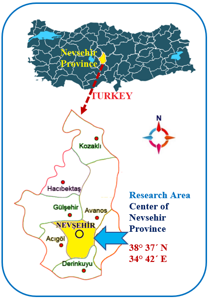
The central of Nevşehir Province is the soils formed by the erosion of tuff and tuff rocks. The soils in Kaymaklı, Çardak and its surroundings are sandy and alluvial and very fertile soils (Engiz, 2007). Nevşehir is very poor in terms of vegetation. It holds a large share in potato production as agricultural products, and the food and beverage industry related to grapes has an important place in the economy. In addition to these, pumpkin, sugar beet, wheat, barley, rye, broad bean, chickpea, beans, lentils, garlic can be grown in the province ( (Anonymous, 2019) ). The study area, which is the subject of the research, is given in Figure 1 .
SPATIAL ANALYSIS OF LAND AND SOIL PROPERTIES
In order to spatially evaluate the land and some soil properties of the study area, 1/25.000 scale digital soil maps were used (Anonyomous, 2000). Numerical data were classified by using of Arc GIS 10.3.1 program, which is one of the Geographical Information Systems (GIS) software (Anonymous, 2010). With the help of the analyzed spatial data, the land use capabilities, large soil groups, soil depths, erosion and slope classes of the research area were spatially evaluated. The evaluations made are interpreted in accordance with the criteria presented in the Technical Instruction of the Ministry of Agriculture and Forestry (Turkey), Soil and Land Classification Standards, and spatial distribution maps related to the land and soil characteristics were created (Anonymous, 2005). Detailed explanations of the land use capability classes of the research area evaluated within the scope of the study are summarized below.
Land Classes
I. Class Land; It is the land containing flat or nearly flat, deep, fertile and easily cultivated soils where conventional agricultural methods can be applied. There may be little water and wind erosion on this class of land. Soils have good drainage and are not subject to flood damage. II. Class Land; Slightly sloped, moderately eroded, moderately thick soil, and occasionally moderately flooded soils. III. Class Land; Soils in this class are moderately inclined, too sensitive to erosion, too wet, too sandy or gravelly, low water holding capacity and less fertile soils. IV. Class Land; The most distinctive features of soils in this class are poorly drained, less inclined, not subject to erosion, and known to have low fertility. V. Class Land; These soils, which are generally stony and wet, are flat or nearly flat. Soils that are not exposed to excessive water and wind erosion. VI. Class Land; Lands in this soil class are heavily sloped and subject to severe erosion. This class of soils is exposed, wet or very dry, or not suitable for cultivation for other reasons.
VII. Class Land; It is the soil group that is very inclined, eroded, stony and faulty, and includes outcrop, dry, swampy or some other unsuitable soils. It can be used as a meadow or forest, provided that great care is taken. If the vegetation on it is reduced, erosion becomes very severe. VIII. Class Land: These lands contain features that prevent them from being used as meadows or forests. Such lands are used as an environment for natural life, as well as as a resting place, or they are kept as a catchment area for flowing waters. These lands; It covers marsh, desert, lands containing very deep ravines and high mountainous, very faulty, stony lands (Anonymous, 2005).
Large Soil Groups
The explanations used in the spatial classification of the large soil groups of the research area are given in detail below.
Alluvial Soils: These are young soils that usually form on fresh sedimentary deposits and are either absent or very poorly developed. There are different mineral layers. These lands are mostly under the influence of ground water. Yield varies.
Brown Soils: These soils are mostly found in arid and semi-arid climates. The natural vegetation on them consists of short grass and bushes. These are soils rich in calcium. Natural drainage is good. Their color is brown. Organic matter content is moderate. These soils remain dry for long periods in summer. The temperature is low in winter and spring, when most of the precipitation falls. Therefore, except for short periods in spring and autumn, chemical and biological activities in the soil are slow. Reddish Brown Soils; Except for the color, it shows great similarity with Brown soils. Again, like them, they are found in arid and semi-arid climates. The natural vegetation is grass and bushes. Natural drainage is good. Biological activity is low in these soils. Natural yields are high.
Colluvial Soils: They are young soils formed on the material called collivium and deposited by gravity, landslide, surface flow or side streams carried over short distances at the foot of steep slopes, and their properties are more similar to the surrounding upper land soils. They contain floors containing different particle sizes according to the severity of precipitation and flow, and the degree of slope.
Regosols: These are very sandy, low water holding capacity, highly permeable shallow soils formed on loose and unconnected deposits. They have an underdeveloped profile. Plant roots can penetrate into the main material.
Limeless Brown Soils: These soils have a dark layer on top and a slightly different layer on the bottom. Soils are lime-free and the reaction is acid, neutral or calcareous. Their natural efficiency is not much (Anonymous, 2005).
Soil Depth Classes
The criteria used in the depth classification as a result of the spatial analysis of the Nevşehir central district borders examined in the research are given in Table 1 .
|
Symbol |
Class |
Soil Depths (cm) |
|
A |
Deep |
> 150 |
|
B |
Medium Deep |
90-150 |
|
C |
Shallow |
50-90 |
|
D |
Too Shallow |
20-50 |
Erosion Classes
|
Erosion Classes |
Explanations |
|
1 |
Light (less than 25% of topsoil eroded) |
|
2 |
Hydrangea (25-75% of topsoil eroded) |
|
3 |
Severe (more than 75% of topsoil and less than 25% of subsoil eroded) |
|
4 |
Very Severe (all topsoil, 35-75% of subsoil eroded) |
Erosion is expressed as the removal of soil in its current state by being carried by rivers or external effects. The erosion classes of the study area were examined spatially and the criteria presented in Table 2 were used for classification.Slope Classes
Land slope in agricultural production is one of the most important factors affecting agricultural activities. Knowing the slope of the land provides important contributions to the planning of agricultural practices to be made. In this sense, the land slope features in the study area were spatially evaluated and classified according to the criteria given in Table 3 .
|
Slope Classes |
Slope (%) |
Explanations |
|
0 |
0-2 |
Straight or Near straight |
|
1 |
2-6 |
Slight Slope |
|
2 |
6-12 |
Medium Slope |
|
3 |
12-20 |
Steep slope |
|
4 |
20-30 |
Very Steep Slope |
|
5 |
30-45 |
Cliff |
|
6 |
45+ |
Very Cliff |
RESEARCH FINDINGS
Some features of the Nevşehir central borders, which were examined within the scope of the study area, were spatially analyzed using 1/25.000 scaled digital maps. In this context, the major soil groups, land use capability classes, current land uses, soil depths, erosion and slope distributions of the research area are summarized below under the headings.
SPATIAL ANALYSIS OF LAND USE CAPABILITIES
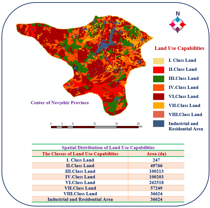
The spatial distribution of land use capability classes of Nevşehir central borders is seen in detail on the map presented in Figure 2 .
Considering the spatial distribution of land use capability classes within the borders of Nevşehir central district, VI. It is seen that class lands are in the majority and constitute an area of 262518 da. Areas in this class are heavily sloped and subject to severe erosion. Such areas are wet or very dry and are not suitable for tillage. The area of 247 decares in the study area constitutes Class I lands. This class of lands are flat and arable lands and are the most suitable areas for agricultural production.
SPATIAL ANALYSIS OF LARGE SOIL GROUPS
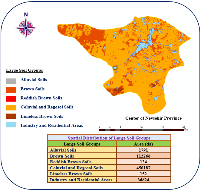
The analyzes of large soil groups in center of Nevşehir province borders and study area were evaluated in Arc GIS software, and the spatial distribution of large soil groups is presented as a map printout in Figure 3 .
When the large soil groups in center of Nevşehir province borders are examined in general, it is determined that regosol and colluvial soils dominate a very large area and this area is 450187 Regosol soils are loose and highly permeable soils. Brown soils dominate the area in general, and the area covered by these soils is calculated as 112266 decares. It is seen that reddish brown soils in the region have the least area with 124 da. Reddish brown soils are fertile soils with low biological activity.
SPATIAL ANALYSIS OF SOIL DEPTHS
Soil depth classes of the study area and center of Nevşehir province borders were spatially evaluated and the results obtained are presented in detail on the map given in Figure 4 .
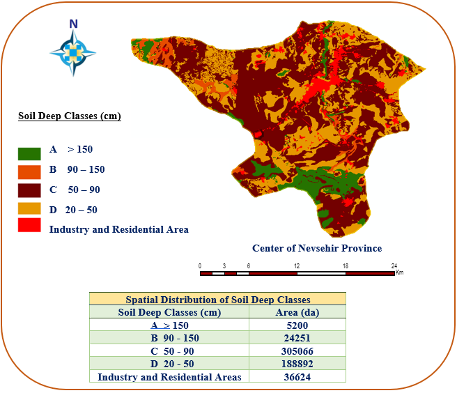
It is seen that the soils of C class depth are generally formed within the borders of Nevşehir center. Class C soil depth represents the shallow soil depth class and it is known that the soil depths in these areas vary between 50-90 cm. The areal distribution of the C class soils constitutes 54.5% of the total area with 305066 decares. Class A soils with a soil depth of more than 150 cm correspond to 0.9% of the total area and the soil depth in such areas will provide significant contributions in terms of agricultural production. Areas with B class soil depth are classified as medium deep soils and the soil depths in such areas vary between 90-150 cm. Class B soil areas within the borders of Nevşehir center correspond to 4.3% of the total area with 24251 decares.
SPATIAL DISTRIBUTIONS OF LAND SLOPE
Slope is a condition that affects agricultural production and has important effects on soil erosion transport. The spatial analysis results of the land slope distributions within the borders of Nevşehir center are given in Figure 5 .
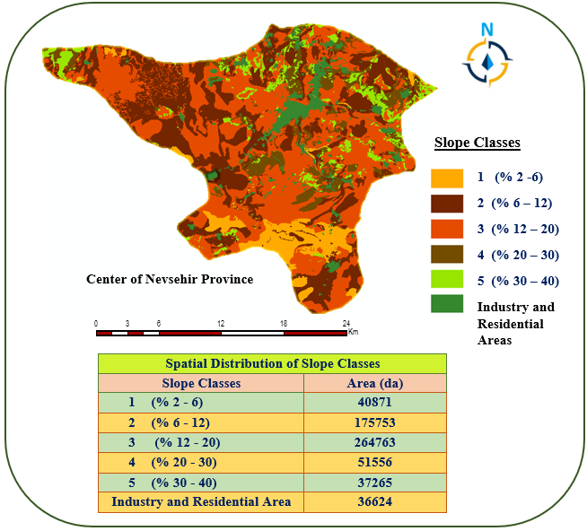
Considering the slope groups of the soils throughout the center of Nevşehir, it is seen that the steep sloped 3rd degree sloped lands are formed and it has the highest value with 264763 da in this area. The 1st degree lands expressing slightly sloping lands have an area of 40871 da. Slightly sloping areas with grade 1 slope group constitute 3.5% of the total area. It was determined that the ratio of the lands with the middle slope group of the 2nd class in the total area was 14.9%.
SPATIAL DISTRIBUTIONS OF EROSION DEGREES
Erosion is a concept that expresses the transportation and removal of soil by being exposed to all kinds of effects. Erosion classes in the study area were spatially examined and the results are presented in Figure 6 .
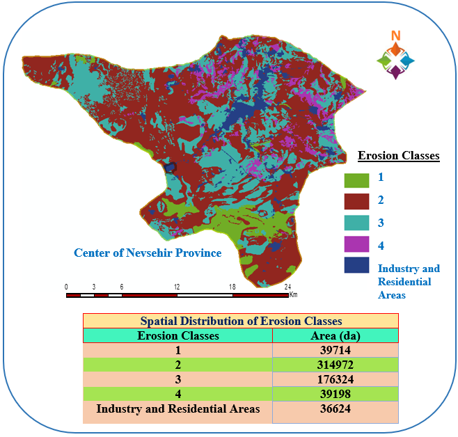
When we look at the area in general, it has been determined that the soils with the 2nd degree erosion class are mainly formed and this area covers an area of 314972 da. It can be said that 25-75% of the soils in such areas have been transported by erosion, and over time, this transport shows an increasing continuity depending on environmental conditions. It is known that the areas with the 4th degree erosion group have less area with 39198 decares than the others, and these soils tend to be exposed to erosion at a very severe (35-75%) degree. It is seen that the areas exposed to the 4th class erosion degree, where 35-75% of the entire upper soil layer and subsoil are exposed to erosion by being exposed to severe erosion, constitute 6.5% of the total area.
SPATIAL DISTRIBUTIONS OF CURRENT LAND USES
The spatial distributions and area values of the current land uses of the areas within the boundaries of the study given in Figure 7 .
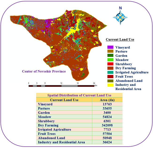
It has been observed that dry agricultural areas dominate the area and cover an area of 342098 decares. The area covered by dry agricultural lands constitutes 56.4% of the total area. In the northern parts of the field, there are vineyard areas in an area of 13763 da and this area corresponds to 2.3% of the total area. Orchard areas constitute 9.5% of the total area, irrigated agricultural areas constitute 1.3% of the total area with 7713 da and meadow areas constitute 9% of the total area.
CONCLUSION
Soil science, which emerged with the need for more efficient and quality management of soils, has been used for only sixty years. With the training of experts in the field of soil, studies in this field have accelerated and soils have been gradually protected against many problems. With the establishment of the soil water organization, the importance of soil resources and the examination of soils, the need to know and map soil properties arose (Çullu, 2012).
Sustainable soil management means taking precautions against the effects that will harm the soil such as erosion, proper processing, knowing environmental conditions, etc. calculates the effects and plays a major role in protecting the soil (Mollavelioğlu, 2009).
Nevşehir province has an important share in potato, grape and pumpkin seed production. Especially the suitable soil and climate structure allows such products to be grown in the region. Considering the classification of land use capability of the central district of Nevşehir, VI. class land lands and constitutes the area of 262518 da. Class I lands cover an area of 247 decares.
Considering the large soil groups, it was determined that colluvial and regosol soils were at 450187 decares and this value covered the majority of the region. Brown soils constitute the area of 112266 da. When the depth classes were examined, it was seen that D class soils, which represent very shallow soils, consisted of the area in 188892. It has been determined that areas with soil depth greater than 150 cm are 5200 da. Slightly sloping areas (1, 2-6%) in the study area cover an area of 40871 da. Areas in the middle slope class (2, 6-12%) constitute an area of 175753 da.
The study area is a region with a high probability of being exposed to erosion in terms of its geographical structure and vegetation. The 4th degree erosion class representing the most eroded area in Nevşehir central district constitutes an area of 39198 decares and it is known that these soils tend to be subject to very severe (35-75%) erosion.
When the current land uses are examined, it has been determined that the dry agricultural lands, which are determined to form the most area in the region, cover an area of 342098 da. Industry and industrial areas cover an area of 36624 decares and pasture areas cover an area of 33655 decares.
In this study, spatial analyzes were carried out using 1/25.000 scaled digital soil maps. In classification, current land use, large soil groups, soil depths, soil slope group and erosion degrees were classified using Arc GIS 10.3.1 software and presented in detail in the form of map outputs. In this context, the soil potential of the central district of Nevşehir has been tried to be determined using the Geographical Information System. This study will be a basis for agricultural studies in Nevşehir province and will be useful for the implementation of the decisions to be taken.
ACKNOWLEDGEMENTS
This article has been prepared by making use of some results of the Master's Thesis titled “Determination of Heavy Metal Pollution in Nevsehir Organized Industrial Zone Soil and Spatial Analysis with Geography Informatıoin Systems (GIS)”conducted at Nevşehir Hacı Bektaş Veli University, Institute of Science, Department of Environmental Engineering. In addition, the study was supported by the Scientific Research Projects Unit of Nevşehir Hacı Bektaş Veli University with the project number ABAP20F26 and within the scope of the TEMA Foundation, Turan Demiraslan Scholarship program.
