
|
|
|
|
ANALYZING THE CAUSE OF TIDAL FLOODING IN RANDUSANGA KULON VILLAGE, BREBES DISTRICT, BREBES REGENCY
Atiyah Barkah 1![]()
1 Civil
Engineering, Wijayakusuma University, Indonesia
|
|
|
ABSTRACT |
|
|
In Indonesia, many regions experienced inundation as a result of the rise of seawater. One of them is the coast of Randusanga Kulon village. The coastal area of Randusanga Kulon village has recreation spots and ponds. These areas are located at the edge of a river estuary which is directly adjacent to the sea. On the other hand, the settlement area is located just 3 km from the seaside. Therefore, when a high tide occurs, the recreation, pond, and settlement areas will be hit by tidal floods. This study aimed to analyze the causes and impacts of tidal floods that hit Randusanga Kulon Village of Brebes District of Brebes Regency. The methods
used to process the data are the Formzahl and Admiralty methods. The result
of calculating using the admiralty method is that Brebes Sea has Mixed
Semi-Diurnal type of daily tides with a Formzahl value of 0,9948. The value
of HHWL was calculated to determine the prediction of seawater rise. By using
the Admiralty Method the result is 47 cm, and by using SLR data due to global
warming, it is 30 cm. |
|||
|
Received 01 June 2024 Accepted 04 July 2024 Published 24 July 2024 Corresponding Author Atiyah
Barkah, barkahatiyah.pwt@gmail.com
DOI 10.29121/ijetmr.v11.i7.2024.1474 Funding: This research
received no specific grant from any funding agency in the public, commercial,
or not-for-profit sectors. Copyright: © 2024 The
Author(s). This work is licensed under a Creative Commons
Attribution 4.0 International License. With the
license CC-BY, authors retain the copyright, allowing anyone to download,
reuse, re-print, modify, distribute, and/or copy their contribution. The work
must be properly attributed to its author.
|
|||
|
Keywords: Flood, Sea
Wave, Tide, Tidal Flood |
|||


1. INTRODUCTION
Nowadays, some regions in Indonesian waters are often hit by tidal floods. One of them is Randusanga Kulon Village of Brebes District of Brebes Regency. In Randusanga Kulon Village of Brebes District of Brebes Regency, there is a recreation area with the name of Randusanga Indah Beach located at the edge of the river estuary that is directly adjacent to the sea, so that when high tide occurs, the recreation area has the potency to be hit by a tidal flood. Anggrain et al. (2012)
For example, in
2022, the coastal tourism area of Randusanga Kulon Village experiencing a tidal
flood.
Figure 1

|
Figure 1 Inundation
in Randusanga Kulon Village that Hit by Tidal Flood. Source detik.com,
2022 |
Aside from sea tides, tidal flood is caused by several factors. Therefore, this study analyzed the factors that cause tidal floods in Randusanga Kulon village of Brebes District of Brebes Regency. Based on the background, researchers analyzed tidal floods in Randusanga Kulon Village of Brebes District of Brebes Regency to determine a good concept of disaster countermeasure for that location. Anonymous (2020)
A
tidal flood is a phenomenon in which land overflows by
seawater caused by sea tides that inundate coastal areas lower than
the mean sea level. Tidal floods occur because of land use changes in coastal
areas, land subsidence in coastal areas, the lowering of the groundwater level
caused by groundwater overuse, bad groundwater recharge in conservation areas,
and the rise of sea level because of global warming Cahyaningtias (2018).
1.1. Problem Formulation
Based on above
background, the formulated problems are :
1) What factors caused tidal floods in Randusanga
Kulon Village
of Brebes District of Brebes Regency?
2) What are the impacts of tidal
floods in Randusanga Kulon Village of Brebes District of Brebes Regency?
1.2. Study Objectives
This study aimed to :
1) To
find out the cause of tidal flood in Randusanga Kulon Village of Brebes District of Brebes Regency
2) To
analyze the impact of tidal flood in Randusanga Kulon Village of Brebes District of Brebes Regency
1.3. Study Boundaries
Considering the limited study
time, the study set up boundaries as follows :
1)
Determine the wave height and
period using the hindcasting method acquired from wind data processing.
2)
This study focused only on tidal
floods that had occurred.
3)
Study location visits were
carried out only in the coastal area of Randusanga Kulon Village.
2. MATERIALS AND METHODS
2.1. Location
This study was carried out in Randusanga Kulon Village of Brebes District of Brebes Regency located
approximately 3 km from the seashore. Brebes Regency has a total area of
1.769,62 km2 with a 60,74 km coastline that extends from the Brebes District in
the East End to the Losari District in the West End. Geographically, Brebes Regency is located at 6̊ 44’56’5’’ -
7̊ 20’51,48 South latitude and 108̊ 41’37,7’’ - 109̊ 11’28,92’’
East longitude coordinates and directly borders with West Java Province.
Figure 2
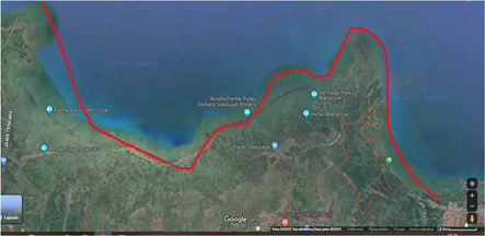
|
Figure 2 Study Location Source Google Earth 2022 |
2.2. Method
Figure 3
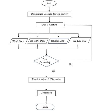
|
Figure 3 Study
Flowchart |
This study uses a quantitative
method. The quantitative method consists of numbers, statistics, and tables.
Quantitative study is a process of gaining knowledge by using data in the form
of numbers as a tool to analyze information about something that needs to be
found Kasiram (2008)
3. RESULTS AND DISCUSSIONS
Below is an analysis of Sea Tide classification that
counted with the Formzahl formula :
![]()
Classification of Sea Tide Types according to Ongkosongo
& Suyarso (1989) with the above Formzahl value can be seen in Table 1.
Table 1
|
Table 1 Analysis of Sea Tide Classification |
||
|
0 < 0,25 |
= |
Semi Diurnal |
|
0,25 < 1,50 |
= |
Mixed Semi – Diurnal |
|
1,50 < 3,00 |
= |
Mixed – Diurnal |
|
3,00 < ~ |
= |
Diurnal |
|
Source Jeri Kurniawan, 2014 |
||
Based on the above Sea Tide
classification, Brebes Sea has a Mixed Semi-Diurnal type of tide. It means that
in the Brebes Sea, within one day there are two high tides and two low tides
with different heights. Nichollas (2002)
Table 2
|
Table 2 Formzahl
Value of the Brebes Sea in 2022 |
|
|
Time |
Formzahl Value |
|
January |
0,6717 |
|
February |
0,5436 |
|
March |
0,4049 |
|
April |
0,4136 |
|
May |
0,5618 |
|
June |
0,6749 |
|
July |
0,6680 |
|
August |
0,5476 |
|
September |
0,4409 |
|
October |
0,4509 |
|
November |
0,9948 |
|
December |
0,6058 |
|
Source Results of Calculation |
|
1)
Brebes Coast Characteristics
Land Use
Table 3
|
Table 3 Land Use Classification Based on Satellite Imagery |
|||||
|
Number |
Types of Land |
Symbol |
Area |
Description |
|
|
Ha |
% |
||||
|
1 |
Coastal area |
|
3039,70 |
1,72 |
Waters |
|
2 |
Bush |
|
4006,00 |
2,26 |
Undeveloped land |
|
3 |
Forest |
|
12032,00 |
6,79 |
Tree Vegetation |
|
4 |
Grassland |
|
107,04 |
0,61 |
Plant Vegetation |
|
5 |
Plantation |
|
66284,70 |
37,45 |
Similar Vegetation |
|
6 |
Farm |
|
11502,30 |
6,49 |
Mix Vegetation |
|
7 |
Ricefields |
|
70605,20 |
39,89 |
Wetland Vegetation |
|
8 |
Settlement |
|
8456,10 |
4,78 |
Developed Land |
|
9 |
Total |
177000,00 |
100,00 |
||
Figure 4

|
Figure 4 Map of Land Use of Brebes Regency in
2022 |
2) Tidal Flood
Spread
The area of tidal flood spread
over almost the entire Brebes coast. The inundation area is 37,87 km2 or 3.787 Ha. Villages that were affected by the Tidal
Flood are Limbangan, Karangdempel, Prapag Lor, Prapag Kidul, Pangaradan,
Griting, Pulogading, and Randusanga Kulon.
Figure 5

|
Figure 5 Map
of Tidal Flood in 2022 |
4. CONCLUSIONS and RECOMMENDATIONS
4.1. Conclusions
Based on the
results, the study can be concluded as follows :
1) The result of the calculation
using the admiralty method is that Brebes Sea has a Mixed Semi-Diurnal tide type with a Formzhal value
of 0,9948. HHWL value is calculated to predict the rise of the sea
surface, by using the Admiralty method the result is 47 cm. And by using SLR
data on global warming the result is 30 cm.
2) Area characteristics review on the condition of Brebes
Regency which is based on land use, the overall study area of 177.000 ha with
each class percentage as follows: Coast area 1,72%, Bush 2,26%, Forest 6,79%,
Grassland 0,61%, Plantation 37,45%, Farm 6,49%, Ricefield 39,89%, Settlement
4,78%. Based on the height of elevation, the study area has an elevation of
0-200 mdpl of 119.431,67 ha area which is categorized as low. Based on the
level of slope Brebes coast has the highest area value of 97.355,14 ha area of
0-8% flat relief.
3) The result of tidal flood inundation modeling in 2022
shows a distribution area of 3.787 ha. The regions that experiencing inundation
are 13 villages that are directly adjacent to the sea.
4.2. Recommendation
Based on the study results, it is recommended to conduct further studies related to other factors that influence the rise of sea surface such as extreme climate, sea waves, wind, and land subsidence in the studied area. On the other hand, for the application of this study, it is expected to become a model of tidal flooding in coastal areas as a warning for the community to be more responsive towards that disaster. Moreover, this model can be used as a guide for the government in tidal flood disaster prevention and control.
CONFLICT OF INTERESTS
None.
ACKNOWLEDGMENTS
None.
REFERENCES
Anggraini, N., Trisakti, B., & Soesilo, T. E. (2012). Pemanfaatan Data Satelit Untuk Analisis Potensi Genangan dan Dampak Kerusakan Akibat Kenaikan Muka Air Laut (Application of Sattelite Data to Analyze Inundation Potential and The Impact of Sea Level Rise), Pengindraan Jauh Journal, 9(2), 140-151.
Anonymous (2020). Sejarah Kabupaten Brebes (The History of Brebes Regency), Retaken from the Brebes Regency Government.
Nichollas, R. (2002). Analysis of Global Impact of Sea Level Rise, Physics and Chemistry Journal of the Earth, 27, 1455-1466. https://doi.org/10.1016/S1474-7065(02)00090-6
Nugroho, S. H. (2013). Prediksi Luas Genangan Pasang Surut (ROB) Berdasarkan Analisis Data Spasial di Kota Semarang, Indonesia (Inundation Area Prediction based on Spatial Data Analysis in Semarang, Indonesia), Lingkungan Dan Bencana Geologi Journal, 4(1), 71-87. http://dx.doi.org/10.34126/jlbg.v4i1.51
Saputro, E. A, Gunawan, T., & Suprayogi, S. (2021). Kajian Tipologi Pesisir di Muara Sungai Pemali Kabupaten Brebes Provinsi Jawa Tengah (Study of Coastal Typology at the Pemali River Estuary, Brebes Regency, Central Java Province), 22(1), 98-112. https://doi.org/10.23887/mkg.v22i1.32645
Setiady, D. (2015). Identifikasi Kerusakan Pesisir Akibat Konversi Hutan Bakau Menjadi Lahan Tambak Di Kawasan Pesisir Kabupaten Cirebon (Identification of Coastal Damage caused by the Conversion of Mangrove Forest to Fishpond). Geologi Kelautan Journal, 13(1). https://doi.org/10.32693/jgk.13.1.2015.258
Suripto, I. (2022). Rob Terjang Randusanga Kulon Brebes Warga akan Diungsikan (Tidal Flood hit Randusanga Kulon Village Brebes Regency, Citizen will be Evacuated), Detik Jateng News.
Syafitri, A.W., & Rochani, A. (2021). Analisis Penyebab Banjir Rob di Kawasan Pesisir (Analysis of the Cause of Tidal Flood in Coastal Area.), Kajian Ruang Journal, 1(1). https://doi.org/10.30659/jkr.v1i1.19975
|
|
 This work is licensed under a: Creative Commons Attribution 4.0 International License
© IJETMR 2014-2024. All Rights Reserved.