
|
|
|
|
SPATIAL ANALYSIS OF SOIL RESOURCES POTENTIAL WITH GIS MAPPING IN THRACE REGION OF TÜRKİYE
M. Cuneyt Bagdatli 1![]()
![]() ,
Esra Can 2
,
Esra Can 2![]()
1 Assistant
Professor, Department of City and Regional Planning, Faculty of Architecture, Nigde Omer Halisdemir University,
Nigde, Türkiye
2 Graguated from MSc Programme in Nevsehir
Hacı Bektas Veli University, Institute of Science, Department of
Environmental Engineering, Nevsehir, Türkiye
|
|
|
ABSTRACT |
|
|
This research
was carried out to evaluate the spatial distribution of land use
capabilities, current land uses, some geographical data and soil properties
by using 1/25.000 scaled digital soil maps in Thrace Region of Türkiye. One
of the GIS programs (Arc GIS 10.3.1) in study has been used. In the results
of the research; II. class lands (8,046.9 km2) cover the largest area. It was
evaluated that the V. class lands (35.1 km2) covered the least area. Dry
farming takes place on an area of 12322.4 km2. The vineyard areas cover the
least area, and the total area is determined to be 76.75 km2. It has been
observed that residential areas are 675.4 km2 and industrial areas are 20.5
km2. The area covered by stony soils was 1399.2 km2 and salty alkaline and
poorly drained soils were observed in an area of 3.2 km2. The results
obtained from the study were presented to users within a database. The
results of the research will provide important contributions to the investor
organizations operating in the Thrace Region of Türkiye. |
|||
|
Received 29 December 2022 Accepted 30 January 2023 Published 14 February 2023 Corresponding Author M. Cuneyt Bagdatli, cuneytbagdatli@gmail.com DOI 10.29121/ijetmr.v10.i2.2023.1296 Funding: This research
received no specific grant from any funding agency in the public, commercial,
or not-for-profit sectors. Copyright: © 2023 The
Author(s). This work is licensed under a Creative Commons
Attribution 4.0 International License. With the
license CC-BY, authors retain the copyright, allowing anyone to download,
reuse, re-print, modify, distribute, and/or copy their contribution. The work
must be properly attributed to its author.
|
|||
|
Keywords: Spatial
Mapping, GIS, Land and Soil Properties, Thrace Region, Türkiye |
|||

1. INTRODUCTION
Soil consists of sand, clay, silt, humus, and mineral substances formed as a result of the breakdown of rocks. Rocks that are heated during the day expand, and when the temperature drops in the evening, they contract again. This event creates cracks on the rocks. Water entering the cracks freezes in cold seasons and expands the crack. This event, which has been repeated for millions of years, eventually turns rocks into stones and stones into soil Fanning & Fanning (1989).
Since the beginning of the 21st century, environmental problems have increased with the development of industry and technology. Air, water, and soils have been severely damaged. It has been noticed later that soils deteriorate because they can absorb possible effects better than other elements. Soil is home to many living things and is the source of life for many living things. For this reason, its properties should be known and analyzed well.
Soil variability is a result of natural and anthropological processes that are effective at different time and space scales. This natural variability in soils is due to geological and soil formation processes Bagdatli & Arslan (2020). This situation has caused various problems on our lands Tekes (2017). Plant nutrients that are depleted from the soil or are not sufficient for plant growth in the soil can only be determined as a result of soil analysis Taban et al. (2004). Geography Information Systems (GIS) can be defined as an information system that provides the storage, analysis and transfer of information obtained as a result of location-based data to users. In another sense, GIS can be expressed as a tool that spatially collects and stores the data on the earth, can transform and analyze this data, and enable it to be viewed by users Olgen (2002). In this research, land use capabilities, determination of some soil and land characteristics were analyzed and classified in GIS by using 1/25.000 scaled digital soil maps. As a result of the study, some soil and land features of the Thrace region were presented to users within a database Dingil et al. (2010).
2. MATERIAL and METHOD
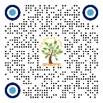
Thrace region: Located in southeastern Europe, it is the region that includes the continents of southern Bulgaria, northeastern Greece, and Türkiye on the European continent. The geographical location and location of the region where the study area is carried out is shown in Figure 1.
Figure 1
|
Figure
1 Location of
the Research Area (Thrace Region of Türkiye) |
Thrace Region constitutes 2.99 % of Türkiye's territory. The region is surrounded by the Istranca (Yıldız) Mountains and the Bulgarian border in the north, the Black Sea in the northeast, the Bosphorus in the southeast, the Marmara Sea, the Dardanelles, Ganos (Isiklar) and Koru Mountains in the south, the Aegean Sea in the southwest, the Meriç River and the Greek border in the west Gungor et al. (2015).
There are forests of beech and rhododendron, generally located in the northern parts of the region. Apart from these, there are plants such as hornbeam species, hazelnut, maple, and cranberry in the forests. On the south-facing slopes of the Istranca Mountains, there are oak forests in general. Asan & Yarcı (1993). Thrace Region’s summers are hot, and winters are relatively cold. The average temperature in January is 2.8 °C, the average temperature in July is 23.9 °C and the annual average temperature is 13.2 °C. The average annual total precipitation is 559.7 mm. Most precipitation occurs in the winter, spring, and autumn seasons. There is little precipitation in the region in summer. The ratio of summer precipitation in the annual total is 17.6%. The annual average relative humidity is 69.6% Sensoy et al. (2008).
In this study, land use capabilities, current land uses, geographical data and some soil properties of the Thrace region were spatially analyzed and classified using digital soil maps with 1/25.000 scale. The classification layers used in the study are explained in detail below.
2.1. Land use capabilities
It is important to classify the lands in order to use the agricultural activities and soil in the most appropriate way. In the study, land use capability was divided into eight classes according to their productivity levels Dinc et al. (2005), Dinc et al. (2001). These:
1) Class Land: This land type includes flat lands or nearly flat lands. They are fertile and dominate easily cultivated soils. It corresponds to areas where 70% of irrigated farming activities are carried out, where at least two crops can be obtained per year, and where intensive farming activities are carried out Anonymous (2005), Atalay & Gündüzoğlu (2015).
2) Class Lands: These lands can be easily cultivated. However, special precautions must be taken. These lands have differences that distinguish them from first class lands. For example, mild slope, moderate erosion, moderate flood risk can be seen in these lands Anonymous (2005).
3) Class Lands: It is a moderately good land for hoe crops, which generates more income by using a good crop rotation and applying appropriate farming methods on these lands. Moderate inclination, high susceptibility to erosion, excessive wetness, exposed soil, presence of footstone, excessive sandiness or gravelly, low water holding capacity and low productivity are the characteristics of this class of land Anonymous (2005).
4) Class Land: This type of land has the effect of extreme slope and erosion. However, it is very suitable to use these lands as pasture. It can be carried out in this type of land during transportation to field crops Anonymous (2005).
5) Class Lands: Stony and wetness problems can be seen in these places. Because of these problems, it prevents agricultural activities. But it may be suitable for meadow and forest cultivation. It is not subject to much wind and water erosion Anonymous (2005).
6) Class Lands: these lands are very sloping and subject to severe erosion. They are not suitable for agricultural production Anonymous (2005). These are the lands where erosion problems are experienced on very steep slopes, the climate allows herbaceous vegetation to grow, and the soils are generally shallow and stony. These lands can be benefited as pasture Inan (2019).
7) Class Lands: These lands contain features that will prevent agricultural activities or the cultivation of meadows and forests. These lands can be used as a natural habitat or as a collection area for flowing waters. This type of land includes swamps, deserts, deep valleys, high mountain areas and stony lands Anonymous (2005). Agricultural production activities are not carried out on these lands Atalay & Gündüzoğlu (2015).
2.2. Current Land use
In the current land use, it can be seen how the land is evaluated and whether it is used in accordance with its purpose. The classification layers related to the current land conditions used as dry farming, irrigated agriculture, vineyards and orchards, pasture, meadow, forest, heather bush, abandoned plots, dense residential area in spatial evaluation Anonymous (2005).
2.3. Soil Properties
In the study, some features of the Thrace Region soils were grouped into 15 classes and analysed spatially. In the research, one of the classification layers is Saline, Alkaline and Saline- Alkaline Soils. Such soils have caused salt accumulation from the surface due to the rise of ground waters containing large amounts of salt, floods, and evaporation. Surfaces of saline soils are slightly moist. Due to poor drainage, rust spots of varying degrees are usually encountered in the entire profile. Since their permeability is good, they can be washed easily Bozyigit & Gungor (2011). Barren soils must be properly identified before they can be rehabilitated. In field observations, the soil appearance and the characteristics of the vegetation growing on it are taken into account Kanber et al. (1992). Soil drainage must also be very good. Soil drainage can be defined as the timely and controlled removal of excess water from the plant root zone and soil surface Ozer & Aslan (2004).
2.4. Other Geographical Data
Within the scope of other geographical data of the study area, water surfaces, residential and industrial areas, and areas related to national parks were classified and spatially analysed.
2.5. Spatial Analysis
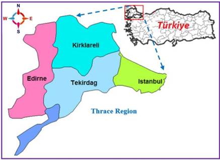
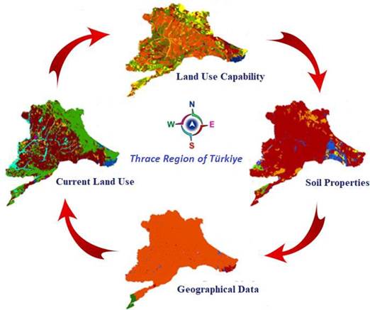
In the research, 1/25.000 scaled digital soil maps prepared by the abolished General Directorate of Rural Services in Türkiye were used Anonymous (2000). Soil and land layers used in classification were determined according to the Soil and Land Classification Standards Technical Instruction of Türkiye Anonymous (2005). Spatial analysis and classification processes were performed using Arc GIS 10.3.1 one of the GIS software Anonymous. (2010). The analysis steps regarding the spatial analysis and classification processes made with the support of Arc GIS 10.3.1 software using digital soil maps are shown schematically in Figure 2.
Figure 2
|
Figure
2 Spatial Analysis Stages of Soil
and Land Data |
3. RESULTS AND DISCUSSIONS
In research, land use capability, current land use, soil characteristics and other geographical data were analysed by using digital soil maps in the Thrace Region, and the spatial maps created are presented under the following headings.
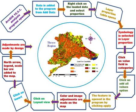
3.1. Evaluation of Land use Capabilities
The land use capability of the Thrace Region was analysed spatially, and their classified and spatial distributions are given in Figure 3.
Figure 3
|
Figure
3 Spatial Distribution of Land Use
Capabilities |
The largest area in the Thrace Region is II. class lands (8,076.9 km2) were observed. II. class lands are spread in the middle part of the region. III. class lands cover an area of 5849.1 km2. Class V lands, on the other hand, covered the least area in the region, but were distributed over an area of 35.1 km2.
3.2. Evaluation of Current Land use
The current land uses of the research area were analyzed spatially. As a result of the analysis, the calculated areal values and spatial distribution results regarding the current land uses are presented in Figure 4.
Figure 4
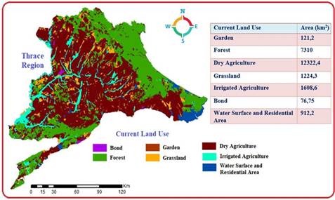
|
Figure
4 Spatial
Distribution of Current Land Use |
Current land uses in the Thrace Region of Türkiye are analyzed in seven classes. It has been seen that dry farming areas are the majority in the Region and the total area is 12322.4 km2. With the climate of the region being an effective reason, it is seen that the forest areas cover an area of 7310 km2. The usage type that creates the least area in the region is the vineyard areas with an area of 76.75 km2.
3.3. Evaluation of Other Geographical Data
The current use cases of Thrace Region lands are classified in 5 different categories. The land use patterns, and areal quantities obtained from the results of the spatial analysis are given in Figure 5.
Figure 5
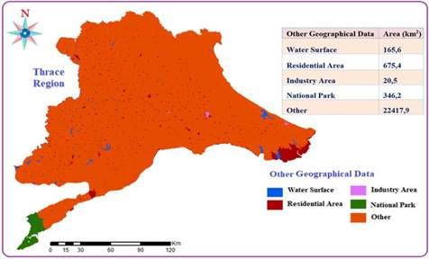
|
Figure
5 Spatial Distribution of Other
Geographical Data |
According to the results of the spatial analysis made in the Thrace Region, it has been determined that the Settlement areas cover an area of 675.4 km2, the National Parks are 346.2 km2 and the Industrial areas cover an area of 20.5 km2.
3.4. Evaluation of Soil Properties
Some soil properties of the study area were spatially analyzed in the Arc GIS environment and the results obtained and the distribution of their areal amounts are given in Figure 6.
Figure 6
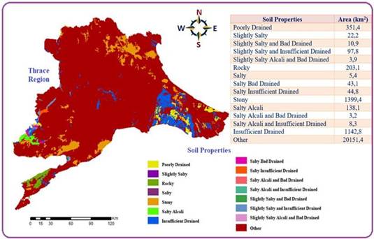
|
Figure
6 Spatial
Analysis of Soil Properties |
It has been observed that 1399.4 km2 of Thrace Region lands have stony lands. These areas were mostly identified in the north of the region. It has been determined that the poorly drained soils cover an area of 1142.8 km2. It has been observed that the areas with poor drainage feature are 351.4 km2. Salty alkaline and poorly drained soils represent the least area with 3.2 km2.
4. CONCLUSION and RECOMMENDATIONS
In this study, the land and soil characteristics of the Thrace Region were examined spatially. These features are Spatial distribution maps of land use capability, current land uses, soil properties and other geographical data were produced. In the Thrace Region, the area covered by the first-class lands is 2012.8 km2. On the other hand, it has been observed that class lands constitute an area of 8076.9 km2. It has been determined that the lands used as irrigated agricultural areas are 1608.6 km2 and the vineyard areas cover an area of 76.75 km2.
It is seen that the settlement areas cover an area of 675.4 km2. It was concluded that the area formed by stony lands covers an area of 1399.4 km2, and saline alkaline soils cover an area of 138.1 km2. The database of spatial distribution maps obtained as a result of the research is as shown in Figure 7.
Figure 7
|
Figure
7 Some Land and Soil Properties
Database of Thrace Region |
Soil and land characteristics should be known very well in agricultural production. For this, it is of great importance that soil and land definitions and analyzes are made and interpreted correctly (Oztekin et al. (2021), Oztekin & Dingil (2022)
In this study, it was seen that the total water surface area and settlement areas in the Thrace Region cover an area of 912.2 km2. First class lands were determined to be in an area of 2012.8 km2. It has been determined that dry farming areas constitute an area of 12322.4 km2 and vineyard areas cover an area of 76.75 km2. It has been observed that national parks are 346.2 km2 and industrial areas are 20.5 km2. It has been observed that the rocky areas are 203.1 km2 and the lands with poor drainage are 351.4 km2.
There are many studies in the literature on spatial evaluation of land and soil properties with Geography Information Systems. In these studies, many more data such as land use capabilities, current land use, soil properties were analyzed and spatial maps were produced by using digital soil maps (Bagdatli & Arslan (2020), Bagdatli & Arslan (2021a), Bağdatli & Ballı (2021), Bagdatl & Can (2020), Bagdatli & Arıkan (2021), Bagdatli & Öztekin (2021), Pekacar & Bagdatli (2020), Bagdatli & Can (2020), Bagdatli & Arslan (2021b), Bagdatli & Arslan (2021c), Oztekin & Koca (2011), Oztekin (2012), Dingil et al. (2014), Oztekin & Kosar (2021)).
CONFLICT OF INTERESTS
None.
ACKNOWLEDGMENTS
None.
REFERENCES
Anonymous. (2000). Sayısal Toprak Haritaları, [Digital Soil Maps]. Mülga Köy Hizmetleri Genel Müdürlüğü (in Turkish).
Anonymous. (2005). Toprak ve Arazi Sınıflaması Standartları Teknik Talimatı. Retrieved 16/4/2020 (in Turkish).
Anonymous. (2010). Arc GIS 10.3.1 Software. ESRI, Environmental System Research Institute.
Asan, A., & Yarcı, C. (1993). Trakya'da Botanik Gezileri, Ekoloji Cevre. Dergisi, 2(7), 26-29. (In Turkish).
Atalay, I., & Gündüzoğlu, G. A. (2015). Türkiye'nin Ekolojik Koşullarına Göre Arazi Kabiliyet Sınıflandırılması, meta Basım Matbaacılık Hizmetleri. İzmir (in Turkish).
Bagdatli, M. C., & Arslan, O. (2020). GIS Mapping of Large Soil Groups, Current Land Use, Soil Depths and Slopes, Soil Erosian in Kırsehir Province of Turkey. World Research Journal of Agricultural Science (WRJAS), 8(1), 265-277. https://doi.org/10.5281/zenodo.4334128.
Bagdatli, M. C., & Arslan, O. (2021b). Nevşehir-Hacıbektaş İlçesi toprak Özelliklerinin Coğrafi bilgi sistemleri (CBS) yardımıyla Değerlendirilmesi, 8. Uluslararası KOP bölgesel kalkınma sempozyumu, Bildiriler kitabı. Ekim, (in Turkish), Sects.5-12, 26-28.
Bagdatli, M. C., & Arslan, O. (2021c). Bazı arazi Özelliklerinin Niğde-çiftlik İlçesi Örneğinde Mekansal olarak İncelenmesi, 8. Uluslararası KOP bölgesel kalkınma sempozyumu, Bildiriler kitabı. Ekim, Sects.13-21, 26-28, (in Turkish).
Bagdatli, M. C., & Arıkan, E. N. (2021). Assessment of Some Land Properties by Using GIS in Niğde Province of Turkey. International Journal of Recent Development in Engineering and Technology (IJRDET), 10(11), 1-9.
Bagdatli, M. C., & Can, E. (2020). Nevşehir Organize Sanayi Bölgesinde Bazı Toprak Özelliklerinin Coğrafi Bilgi Sistemleri (CBS) Ortamında Değerlendirilmesi, uluslararası Marmara Fen bilimleri kongresi Bildiriler kitabı, 2020, aralık, Kocaeli, Türkiye (in Turkish) ; Sects.75-76, 4-5.
Bagdatli, M. C., & Can, E. (2021b). Spatial Analysis of Soil Resources Potential by Using Geography Information Systems (GIS) : A Case Study from Thrace Region, Turkey. International Journal of Innovative Research and Reviews (INJIRR), 5(2), 45-50.
Bagdatli, M. C., & Öztekin, M. E. (2021). Determination of Land Use Capabilities by GIS Analysis in Nigde Province, Turkey. Eurasian journal of Agricultural Research (EJAR), 5(2), 121-129.
Bagdatli, M. C., & Arslan, O. (2021a). Classification and Mapping of Land Use and Some Soil Properties in Kırşehir Province, Turkey. International Journal of Engineering Technologies and Management Research, 8(8), 81-93. https://doi.org/10.29121/ijetmr.v8.i8.2021.1022.
Bagdatli, M. C., & Can, E. (2021a). Spatial Evaluation of Land and Soil Properties in the Example of Nevşehir Province, Turkey. International Journal of Engineering Technologies and Management Research, 8(7), 90-102. https://doi.org/10.29121/ijetmr.v8.i7.2021.1007.
Bağdatli, M. C., & Ballı, Y. (2021). GIS Mapping of Land Slopes, Soil Depths, Erosian Classes, Large Soil Groups and Some Soil Properties : A Case Study of Kayseri Province in Turkey. Universal Journal of Agricultural Research, 9(5), 166-175. https://doi.org/10.13189/ujar.2021.090503.
Bozyigit, R. (2020). Seydikemer İlçesi (Muğla) Topraklarının Özellikleri ve kullanımı üzerine bir Değerlendirme, avrupa bilim ve teknoloji. Dergisi, 18, 695-706 (in Turkish). https://doi.org/10.31590/ejosat.702654.
Bozyigit, R., & Gungor, Ş. (2011). Konya Ovasının Toprakları ve sorunları. Marmara coğrafya dergisi, 24, (169-200) İstanbul, Türkiye (in Turkish).
Dinc, U., Kapur, S., Akça, E., Ozden, M., Senol, S., Dingil, M., Oztekin, M. E., Kizilarslanoglu, H. A., & Keskin, S. (2001). History and Status of Soil Survey Programmes in Turkey and Suggestions on Land Management. Soil Resources of Southern and Eastern Mediterranean countries. CIHEAM, 263-275.
Dinc, U., Senol, S., Cangir, C., Dinc, A. O., Akca, E., Dingil, M., Oztekin, M. E., Kapur, B., & Kapur, S. (2005). Soil Survey and Soil Database of Turkey. European Soil Bureau, Joint Research Centre, 9, 371-375.
Dingil, M., Oztekin, M. E., & Senol, S. (2014). A Methodological Study on Creating a Digital Soil Map from a Conventional Soil Map Via Gis Without Fieldwork on a Stage Farm in the Eastern Anatolia Region of Turkey. Fresenius Environmental Bulletin, 23(10), 2501-2508.
Dingil, M., Öztekin, M. E., Akça, E., & Senol, S. (2010). Updating Soil Characteristics of Çukurova Region (Southern Turkey) Using Geographical Information Systems and Ilsen Software. Indian Journal of Agricultural Research, 44(4), 316-320.
Fanning, D. S., & Fanning, M. C. B. (1989). Soil Morphology, Genesis and Classification. John Wiley & Sons, Inc.
Gungor, G., Konyalı, S., & Turan, D. Ç. (2015). Trakya'da Tarla Ürünlerini (buğday, ayçiçeği, Kanola, çeltik) Üreten İşletmelerin Sosyo-Ekonomik durumu ve Başlıca Gelişmişlik Göstergeleri İtibariyle analizi. bilimsel araştırma projesi sonuç raporu, Namık Kemal üniversitesi. Tekirdağ (in Turkish).
Inan, F. (2019). Ekolojik Koşullara göre arazi kullanım Kabiliyeti Sınıflandırması: Altıeylül İlçesi (Balıkesir). Balıkesir üniversitesi, coğrafya Anabilim Dalı, yüksek lisans tezi. Balıkesir (in Turkish).
Kanber, R., Kırda, C., & Tekinel, O. (1992). Sulama Suyu Niteliği ve Sula mada Tuzluluk Sorunları. Ç.Ü. Ziraat Fakültesi Genel Yay. No. 21, Ders kitapları Yay, 6. Türkiye (in Turkish) ; S.341, Adana.
Olgen, K. (2002). Dikili-Çandarlı Kıyılarında CBS ile Çevresel Duyarlılık Derecesinin Belirlenmesi. Dokuz Eylül Üniversitesi'nin Kıyı ve Deniz Alanları IV. Konferansı, U. 5-8 kasım, 2. Cilt. İzmir (in Turkish).
Ozer, N., & Aslan, C. (2004). Tarımsal drenaj çalışmaları, Sulanan Alanlarda tuzluluk yönetimi sempozyumu Bildiriler kitabı, Sects.59-68, Ankara, Türkiye (in Turkish).
Oztekin, M. E. (2012). Monitoring and Determination of Land Use Types in Large Scale Irrigation Project Areas in Mediterranean Region of Turkey. Journal of Food, Agriculture and Environment, 10(2), 1065-1068.
Oztekin, M. E., & Dingil, M. (2022). Determination of Corn Planting Areas and Yield Forecasting Using Landsat Images. Fresenius Environmental Bulletin, 31(04), 4420-4426.
Oztekin, M. E., & Koca, Y. K. (2011). The Advantages of Quickbird Images for Detailed Soil Survey Studies. Journal of Food, Agriculture and Environment, 9(3&4), 928-931.
Oztekin, M. E., & Kosar, M. (2021). Gis and Remote Sensing are Used by Multi Criteria Decision Analysis Method to Determine the Landside Sensitive Areas of Malatya Province. Fresenius Environmental [Bulletin], 30(04), 3524-3536.
Oztekin, M. E., Antmen, Z. F., & Onat, B. (2021). Monitoring and Yield Estimation of Soybean Using Satellite Data in North Yüreğir Region. Fresenius. Environmental Bulletin, 30(06A), 6602-6608.
Pekacar, A. Y., & Bagdatli, M. C. (2020). Bazı
toprak Özelliklerinin Coğrafi bilgi sistemleri (CBS) yardımıyla
Değerlendirilmesi : İstanbul Anadolu Otoyoluna yakın tarım alanları uygulaması, uluslararası
akademik Araştırmalar
kongresi, Bildiriler kitabı. Türkiye (in Turkish), aralık,
Sects, 87-88, 7-9.
Sensoy, S., Demircan, M., Ulupınar, U., & Balta, I. (2008). Türkiye iklimi, Turkish State Meteorological Service (DMİ), Ankara, Türkiye (in Turkish).
Taban, S., Çıkılı, Y., Kebeci, F., Taban, N., & Sezer, S. M. (2004). Taşköprü yöresinde sarımsak tarımı yapılan toprakların verimlilik durumu ve potansiyel beslenme problemlerinin ortaya konulması. Tarım Bilimleri Dergisi, 10(3), 297-304 (in Turkish). https://doi.org/10.1501/Tarimbil_0000000910.
Tekes, A. (2017). Atalay Yöntemine göre arazi kullanım Kabiliyeti Sınıflandırması : Manisa Şehzadeler İlçesi, Balıkesir Ünivesitesi, coğrafya Anabilim Dalı, yüksek lisans tezi. Balıkesir (in Turkish).
|
|
 This work is licensed under a: Creative Commons Attribution 4.0 International License
© IJETMR 2014-2023. All Rights Reserved.