
|
|
|
|
GEOGRAPHIC INFORMATION SYSTEM MAPPING SENIOR HIGH SCHOOL AND VOCATIONAL HIGH SCHOOL IN BALI ISLAND BASED INTERNET BY USING GOOGLE MY MAPS
Ni Nyoman Supuwiningsih 1![]()
![]() ,
Adam Sheni Martua Malau Pase 2
,
Adam Sheni Martua Malau Pase 2![]()
1 Computer System, ITB STIKOM Bali, Indonesia
2 Information System, ITB STIKOM Bali,
Indonesia
|
|
|
ABSTRACT |
|
|
This study aims to provide information to prospective students and the public about mapping the profiles of SMA (Senior High School) and SMK (Vocational High School) on the island of Bali online through google my map to assist in making decisions in choosing the school as desired because at the time of school selection based on the zoning system. The method used in this study is a field research method which consists of several stages in the flow of analysis, namely Literature Study, Spatial data collection, Internet-based digital map creation using Google My Maps, Integration of spatial data and non-spatial data and implementation. Integration of spatial data and non-spatial data for SMA and SMK in the form of a digital map based on a Geographic Information System using Google My Maps software and a comparison of the number of SMA and a comparison of SMK spread across several regencies /municipalities where almost every regency/municipality has a number of SMA and the number of Vocational High School balanced, based on the results of the analysis that the number of SMA and the number of SMK that are spread out are for SMA and SMK on the island of Bali, namely 179 and 178 with a comparison of about 50.1% for SMA and around 49.9% for SMK. This study focuses on the dissemination of information for high school and vocational schools that are integrated with school profile information packaged in the concept of a Geographic Information System using google my map which can be accessed by prospective new students to decide to choose a school based on the zoning system or distance from where they live. |
|||
|
Received 15 October 2022 Accepted 16 November 2022 Published 05 December 2022 Corresponding Author Ni Nyoman
Supuwiningsih, ninyomansupuwiningsih@gmail.com DOI 10.29121/ijetmr.v9.i12.2022.1259 Funding: This research
received no specific grant from any funding agency in the public, commercial,
or not-for-profit sectors. Copyright: © 2022 The
Author(s). This work is licensed under a Creative Commons
Attribution 4.0 International License. With the
license CC-BY, authors retain the copyright, allowing anyone to download,
reuse, re-print, modify, distribute, and/or copy their contribution. The work
must be properly attributed to its author.
|
|||
|
Keywords: Geographic
Information System, Mapping, Senior High School, Vocational High School,
Google My Maps |
|||

1. INTRODUCTION
Education is
one of the processes carried out in preparing quality, creative and innovative
human resources Kosilah and Septian (2020). Education can also reflect the strata of
human life in society. Indonesia places education as something very important
and primary Sebayang and Tiur (2019). In life in Indonesia Education is one of
the important factors that must be developed According to Law No. 20 of 2003
Education creates teaching and learning situations and learning paths so that
students can actively develop themselves so that they have religious spiritual
abilities, self-control, character, intelligence , noble character and
expertise needed by himself, the community, the nation and the State Renaldi
and Anggoro (2020).
School is a
place to carry out formal educational activities with supporting components
such as teachers, educational facilities, students, school environment and so
on. The large number of high school and vocational schools on the island of
Bali provide opportunities for prospective junior high school graduates and
parents of students to choose a school according to their wishes, but not many
people know the information about school profiles and become an obstacle for
prospective students to choose a school according to their wishes and based on
the location of residence because the zoning system is applied in school
search. High School (SMA) is a secondary education level in formal education in
Indonesia which is carried out after graduating from Junior High School (SMP)
or equivalent and Vocational High School (SMK) is one of the educational
institutions responsible for creating human resources who have the ability,
skills and expertise so that graduates can develop their performance when they
enter the world of work Sarwo et al. (2017). Acceptance of new students is based on
the sub-district area, so it is difficult for the community (parents) to choose
where their children will go to school, because they do not know much
information about each school Sukamto et al. (2017).
Based on these
problems, a Geographic Information System for high school and vocational high
school mapping on the island of Bali is needed based on the internet using
google my maps. Geographic Information System (GIS) is an organized collection
of computer hardware, software, geographic data and personnel designed to
efficiently acquire, store, update, manipulate, analyze and display all forms
of geographically referenced information that can be accessed online. online
via the web Surya and Afri (2020). Geographic Information System (GIS)
consists of three terms, namely System, Information and Geographic is a set of
components or elements that are interconnected between these components/elements
to achieve goals Prahasta (2014). Google my map is part of a
computer-based Geographic Information System (GIS) that is used to process and
store geographic-based data or information Lasut (2020). Google Maps was introduced in February
2005 and revolutionized how maps are on the web, namely by allowing users to
drag maps so they can navigate Natalia
et al. (2020). The purpose of this research is to
provide information to prospective students and the public regarding online
mapping of high school and vocational high school profiles on the island of
Bali to assist in making decisions in choosing the school as desired. The
method used in this research is field research which consists of several
stages: literature study, spatial data collection, non-spatial data collection,
internet-based digital map creation, integration of spatial and non-spatial
data, the last stage is implementation. The software used in making the
application is the Windows 10 operating system, Google My Maps and the Google
Chrome browser. This research is expected to be able to produce internet-based
digital maps that display spatial and non-spatial integration of high schools
and vocational schools on the island of Bali so that this information can be
accessed by prospective students in particular and the community in general
through map links that can be distributed via Facebook, WhatsApp, email, twitter
and other social media.
2. MATERIALS AND METHODS
2.1. Education Concept
Education is a
conscious effort to prepare students through guidance, teaching and/or training
activities for their future roles. Education is guidance or assistance given by
adults to child development to reach maturity with the aim that children are capable
enough to carry out their own life tasks without the help of others Kosilah and Septian (2020). In the current era of globalization,
education is very important. Almost all countries place educational variables
as something important and primary in the context of nation and state
development. Likewise, Indonesia places education as something very important
and primary Sebayang and Tiur (2019).
2.2. Concept of Geographic Information Systems
Geographic
Information System (GIS) consists of three terms, namely System, Information
and Geographic which is a set of components or elements that are interconnected
between these components/elements to achieve goals Prahasta (2014). The concept of information is the result
of data processing and geography is the study of the earth's surface. The
concept of Geographic Information System (GIS) is a collection of components
that interact with each other in data processing to produce geographic
information whose implementation is in the form of digital maps. Geographic information
system can also be defined as an information system that can analyze, store,
update, integrate and display all forms of information related to the earth's
surface.
2.3. Cartographic Concepts
Cartography
comes from the Greek karto or carto which means surface and graft which means
picture or shape. So that cartography is a picture of the earth's surface. In
another sense, cartography is the science of making maps Andi et al. (2018). According to the International
Carthography Association in 1973, Cartography is the art, science and
technology of making maps, as well as covering their study as scientific
documents and works of art.
A map is a
picture of the earth's surface projected onto a flat plane with a certain
scale. The function and purpose of making a map is to show the position or
location on the earth's surface, show the size (area, distance) on the earth's
surface, describe the shape of the earth's surface, present data on the
potential of an area, communicate spatial information, store information,
assist work (road construction, navigation) , planning) and spatial data
analysis (volume calculation).
Google is a
company that started as a search engine and is now growing to expand its
services with more than 50 internet services and products such as Gmail, maps
to software for smartphones and tablets. Google was founded by Larry Page and
Sergey Brin while still students at Stanford University. They both hold 16
percent of the company's stock. They made Google a private company on September
4, 1998.
Google Maps is
a web mapping service developed by Google. This service provides satellite
imagery, street maps, 360° panoramas, traffic conditions, and route planning
for traveling by foot or car. Google Maps is a mainstay for quick searches for
locations related to daily needs, as well as for exploring many new places
without the need to ask a lot of people around. Its features include sharing
those locations. Google Maps was introduced in February 2005 and is a
revolution in how maps are on the web, namely by allowing users to drag maps so
they can navigate them Natalia
et al. (2020).
2.5. Methods
The method used
in this study is a field research method which consists of several stages in
the flow of analysis as follows.
1)
Literature Study
The first stage
is reading reference books and journals related to the concept of Geographic
Information Systems, cartographic concepts, the concept of google my map and so
on.
2)
Spatial data collection
The second
stage is to collect spatial data, namely geographically referenced data on the
representation of objects on earth, in this case collecting the locations of
SMA and SMK on Bali Island.
3)
Collection of non-spatial data
The third stage
is collecting non-spatial data and analyzing the data by identifying entities
and attributes that can be described using ERD (Entity Relationship Diagram)
diagrams.
4)
Making internet-based digital maps using Google My Maps
The fourth
stage is to start making maps of SMA and SMK locations on the island of Bali by
grouping data using layers on Google My Maps.
5)
Integration of spatial data and non-spatial data
The fifth stage
is to input non-spatial data for each of the layers that were created in the
fourth stage. Each attribute that has been previously identified will be
converted in the form of fields in the tables of each layer.
6)
Implementation
The
implementation stage is the last stage in this research, namely implementing
digital maps using Google My Maps which can be shared/shared in the form of
links that can be shared via social media such as Facebook, WhatApp, Twitter
and so on so that maps can be accessed online.
Figure 1
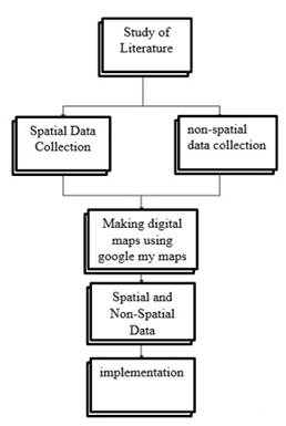
|
Figure 1 Research Flow |
3. RESULTS AND DISCUSSIONS
3.1. Identification of Spatial Data and Non-Spatial Data
The results of the research in identifying non-spatial
data for SMA and SMK schools in each regency/municipality in Bali are shown in Figure 2 in the form of a
digital map as a result of identifying spatial data. Geographic Information
System (GIS) is an information system that can analyse spatial data and
non-spatial data obtained in data collection, the spatial data and non-spatial
data are processed and integrated in a computerized manner so as to produce
geographic information to achieve user goals and needs. Spatial data is data
that has an overview of the area on the earth's surface which is represented in
the form of graphs, maps, images in digital format in the form of rasters and
vectors with a certain value Supuwiningsih,
et al. (2022).
Figure
2
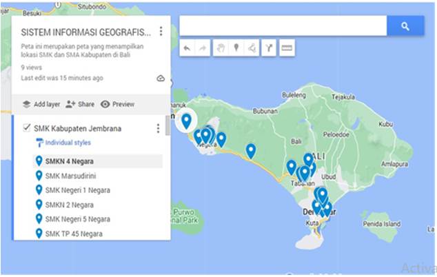
|
Figure
2 Digital Map Using Google My Maps |
Non-spatial
data is data in the form of attributes from spatial data. Attribute data is
table data containing information that describes the existence of objects in
spatial data Fernando et al. (2018). The integration between spatial data and
non-spatial data implemented on Google My Maps can be seen in Figure 3.
Figure
3
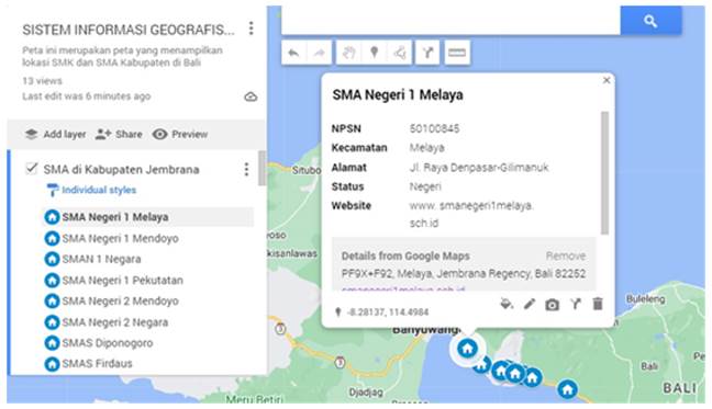
|
Figure
3 Integration of Spatial Data and Non-Spatial Data on High School
Distribution in Jembrana District |
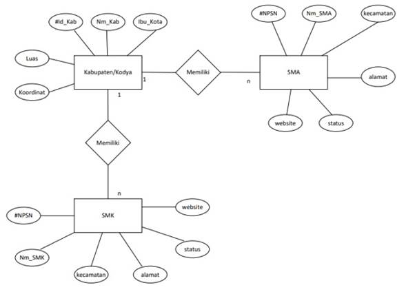
3.2. ERD (Entity Relationship Diagram)
Non-spatial
data that has been identified from the mapping of SMA (Senior High School) and
SMK (Vocational High School) which are spread from all districts/municipalities
on the island of Bali consist of 3 entities namely district/kodya, SMA and SMK.
Each entity has several attributes, the regency entity has the attributes of
district id (id_kab), district name (Nm_Kab), capital city (ibu_kota), area and
coordinates. The SMA entity has the attributes NPSN (National School
Identification Number), SMA Name (Nm_SMA), district, address, status and
website. The SMK Entity has the attributes NPSN (National School Identification
Number), SMK Name (Nm_SMK), district, address, status and website. The
cardinality of district entities with SMA entities is one to many with a
"has" in Indonesian language “memiliki” relationship and district
cardinality with SMK entities is one to many with a "has"
relationship, the ER diagram is shown in Figure 4.
Figure
4
|
Figure
4 ERD (Entity Relationship Diagram) |
3.3. Analysis Results
The data
analysis technique used in this study was to use quantitative analysis
techniques by grouping SMA and SMK spread across Bali by district and
calculating the number of SMA and SMK spread as well as carrying out a process
of comparing the distribution of SMA and SMK on Bali Island, comparing the
number SMA and SMK can be seen in the following Table 1.
Table 1
|
Table 1 Comparison of the Number of SMA and SMK in Each Regency/City |
|||
|
No |
Regency/City |
Number of SMA (Senior high schools) |
Number of SMK (Vocationa High School) |
|
1 |
Jembrana |
13 |
9 |
|
2 |
Tabanan |
17 |
17 |
|
3 |
Badung |
22 |
23 |
|
4 |
Gianyar |
17 |
32 |
|
5 |
Bangli |
9 |
14 |
|
6 |
Klungkung |
13 |
8 |
|
7 |
Karangasem |
20 |
13 |
|
8 |
Buleleng |
36 |
30 |
|
9 |
Kodya Denpasar |
32 |
32 |
|
Total |
179 |
178 |
|
Comparison of
the number of high schools spread across 8 districts and 1
municipality/municipality of Denpasar can be seen in figure 5. The highest
number of SMA is in Buleleng Regency, namely 36 SMA, around 20% and the least
number of SMAs are in Bangli Regency, namely 9 SMA, around 5%.
Figure 5
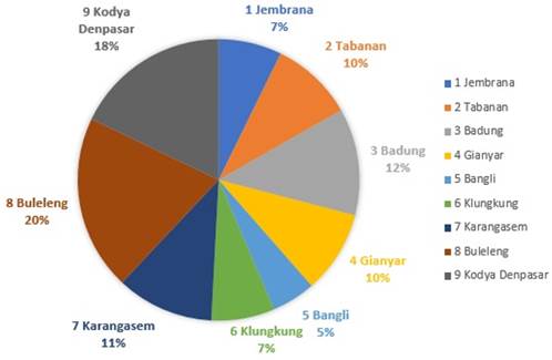
|
Figure 5 Graph of Comparison of the Number of Senior High Schools
(SMA) on the Island of Bali |
Comparison of
the number of SMK spread across 8 districts and 1 municipality/municipality of
Denpasar can be seen in figure 6. The highest number of Vocational Schools is
in Gianyar Regency and Denpasar Municipality, each of which is the same, namely
32 Vocational Schools, around 18% and the least number of Vocational Schools is
in Klungkung Regency, namely 8 Vocational Schools, around 4%.
Figure 6
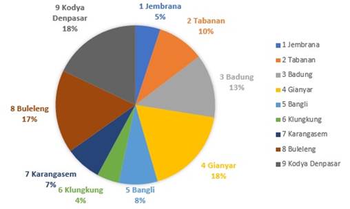
|
Figure 6 Graph of Comparison of the Number of Vocational High
Schools (SMK) on the Island of Bali |
In Figure 7 is a comparison between the number of SMA
and the number of SMK spread across several districts/municipalities on the
island of Bali, based on the results of the analysis that the number of SMA and
the number of SMK spread is for SMA and SMK on the island of Bali respectively
179 and 178 with a comparison about 50.1% for SMA and around 49.9% for SMK, so
the distribution of SMA and SMK is almost the same in all
districts/municipalities on the island of Bali.
Figure 7
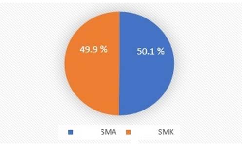
|
Figure
7 Comparison of the Number of SMA and SMK in Bali Island |
4. CONCLUSIONS AND RECOMMENDATIONS
Based on the
results of research on the distribution of high schools and vocational schools
in all districts/municipalities (kodya) in all regions of the island of Bali
which have been grouped by district. Data grouping is also based on the type of
school, namely the type of Senior High School (SMA) and grouped by Vocational
High Schools in each district/municipality on the island of Bali. Data
processing uses quantitative analysis techniques by comparing the number of SMA
and SMK in all regencies/municipalities in the province of Bali.
Comparison of
the number of high schools spread across 8 regencies and 1
municipality/municipality of Denpasar with the highest number of high schools
in Buleleng Regency, namely 36 high schools, around 20% and the least number of
high schools in Bangli district, namely 9 high schools, around 5%. Comparison
of the number of SMK spread across 8 regencies and 1 municipality/municipality
with the highest number of SMK being found in Gianyar Regency and Denpasar
Municipality, each of which is the same, namely 32 SMK, around 18% and the
least number of SMK is in Klungkung Regency, namely 8 SMK, around 4%.
Comparison of the number of SMAs and the ratio of SMKs spread over several regencies/municipalities where almost every district/municipality has a balanced number of SMAs and the number of SMKs except for Gianyar district which has a larger number of SMKs compared to SMA, namely 32 : 17. The ratio between the number of SMAs and the number of SMAs Based on the results of the analysis, the number of SMAs and the number of SMKs spread across the island of Bali is 179 and 178 respectively with a ratio of around 50.1% for SMA and around 49.9% for SMK. The results of implementing the digital map for high school distribution can be shared with everyone who is connected to the internet such as social media Facebook, Twitter, Instagram etc. by clicking on this link https://cutt.ly/yX9ouPZ and the results of implementing this digital map for SMK can be shared with everyone those connected to the internet such as social media Facebook, Twitter, Instagram etc. by clicking this link https://cutt.ly/TX9iSaa. Google Maps will make it easier for users to find SMA/SMK locations and make it easier to get SMA/SMK information Kharistiani and Aribowo (2013).
CONFLICT OF INTERESTS
None.
ACKNOWLEDGMENTS
This research has been supported by ITB STIKOM Bali: encompass the Chairman along with its management team, providing its support and resources. Hope the result of this work can be useful for world community.
REFERENCES
Andi, I.B., Dewi, L.S., and Putro, S. (2018). Kartografi Dasar. Yogyakarta : Ombak.
Fernando, E., Touriano, D.,Murad, D.F and Bimo, A.C. (2018). Pemetaan Dan Analisa Sebaran Tempat Public Pada Kecamatan Jambi Timur Di Kota Jambi Dengan Sistem Informasi Geografis. Jurnal SISKOM-KB (Sistem Komputer Dan Kecerdasan Buatan), 2(1), 5-11, 2018.
Kharistiani, E., and Aribowo, E. (2013)."Sistem Informasi Geografis Pemetaan Potensisma/SMK Berbasis Web (Studi Kasus : Kabupaten Kebumen)", Jurnal Sarjana Teknik Informatika , 1(1),712-720.
Kosilah and Septian (2020)."Penerapan Model Pembelajaran Kooperatif Tipe Assure Dalam Meningkatkan Hasil Belajar Siswa", Jurnal Inovasi Pendidikan. 1(6), 1139-1148.
Lasut, D. (2020)."Integrasi Smartphone Gps Dan My Map Google Pada Penelitian Survey Filariasis 2017 (Studi Kasus Kabupaten Kolaka Utara). In Proceeding Sendiu, 289-295.
Natalia, B.K., Wahyuni, E.S and
Dawamul, A. (2020)."Sistem Informasi Geografis
Pemetaan Tempat Kos Di Samarinda Berbasis Web", Buletin Poltanesa,
21(1),11-17. https://doi.org/10.51967/tanesa.v21i1.320.
Prahasta, E. (2014). Sistem Informasi Geografis : Aplikasi Pemrograman Mapinfo, Bandung : Informatika.
Renaldi, R. and Anggoro, D. A.
(2020). "Sistem Informasi Geografis Pemetaan
Sekolah Menengah Atas/Sederajat Di Kota Surakarta Menggunakan Leaflet Javascript
Library Berbasis Website", Jurnal Teknik Elektro, 20(2), 109-116. https://doi.org/10.23917/emitor.v20i02.10945.
Sarwo E., Suharno, and Indah, W.(2017)."Pengembangan
Standar Pelaksanaan Praktik Kerja Industri (Prakerin) Siswa SMK Program
Keahlian Teknik Pemesinan Di Wilayah Surakarta", Jurnal Ilmiah Pendidikan
Teknik Kejuruan (JIPTEK), 10(1), 22-30. https://doi.org/10.20961/jiptek.v10i1.14972.
Sebayang, S. and Tiur, R. (2019)."Pengaruh Pendidikan, Pelatihan, Dan Motivasi Kerja Terhadap Kinerja Guru Di Sd Dan Smp Swasta Budi Murni 3 Medan", Jurnal Ilmu Manajemen Methonomix, 2(2), 105-114.
Sukamto, Elfizar and Nofriani P. (2017)."Sistem Informasi Geografis Pemetaan Sekolah Berbasis Mobile (Studi Kasus Smp Negeri Di Kecamatan Tampan Pekanbaru)", Jurnal Informatika Upgris,3(2), 50-59. https://doi.org/10.26877/jiu.v3i2.1894.
Supuwiningsih, N.N. et al. (2022). Integrasi Data Spasial Dan Data Non Spasial Sistem Informasi Geografis, Bandung : Media Sains Indonesia.
Surya, H.P and Afri, E. (2020)."Penerapan Sistem Informasi Geografis Berbasis Web Untuk Pengembangan Pariwisata Pada Kabupaten Langkat", Infotekjar : Jurnal Nasional Informatika Dan Teknologi Jaringan, 5(1), 171-174.
|
|
 This work is licensed under a: Creative Commons Attribution 4.0 International License
© IJETMR 2014-2022. All Rights Reserved.