
|
|
|
|
SEDIMENT ANALYSIS IN THE RIVER OF PALEMBANG CITY
RA Sri Martini 1![]()
![]() ,Mira
Setiawati 2
,Mira
Setiawati 2![]()
![]() ,
Fadhilla Rosleni 3
,
Fadhilla Rosleni 3![]()
![]() ,
Fenny Tri Putri 4
,
Fenny Tri Putri 4![]()
![]() ,
Evan Kurniawan 5
,
Evan Kurniawan 5![]()
![]() ,
M. Juan Edwardo 6
,
M. Juan Edwardo 6![]()
![]() ,
Wahyuni 7
,
Wahyuni 7![]()
![]()
1, 2, 3, 4, 5, 6, 7 Civil
Engineering, Department, University of Muhammadiyah Palembang, Indonesia
|
|
|
ABSTRACT |
|
|
Palembang City has several watersheds (DAS), namely the Dam River, Kedukan Bukit River, Sekanak River, and Lambidaro River which are rivers in Palembang City which often experience runoff due to flooding. but there are several problems in the watershed, including the problem of river silting which results in frequent flooding in several river areas during the rainy season. In the last few years, the watershed has not been normalized. Problems in the watershed may also have excessive sediment buildup. If there are no countermeasures, it can lead to silting of the river due to excessive sedimentation. To determine the sedimentation in the watershed, sediment samples were tested using the Duboy's method and the shield's method, the Yang'S method, the Bagnold method, and the Shen and Hung method. The results of
the discussion obtained from the results of the Qt calculation are on the Bendung river using the Duboy's
method = 131.67 tons / year, Shield's method = 131.35 tons / year. Kedukan River The volume of floating sediment in the next
one year is 91,517,472 m³/s for the Duboy's method
and 498,89952 m³/s for the Shield method, and for the average of total
sediment discharge value obtained from each equation, namely Yang method =
0.0091315 tons/sec, for Bagnold method = 0.0038365 tons/sec and Shen and Hung
method = 0.0001495 tons/sec. The average sediment yield that occurs in the Lambidaro River in Palembang City in the next one year is
136.656 kg/year/m. The volume of sediment in the Sekanak
River is 10,495.7 (lb/yr)/ft.
Shield's method Average yield of qb sediment is
4,064.6 (lb/yr)/ft. |
|||
|
Received 15 October 2022 Accepted 05 November 2022 Published 23 November 2022 Corresponding Author RA Sri
Martini, ninikkunc@gmail.com DOI 10.29121/ijetmr.v9.i11.2022.1244
Funding: This research
received no specific grant from any funding agency in the public, commercial,
or not-for-profit sectors. Copyright: © 2022 The
Author(s). This work is licensed under a Creative Commons
Attribution 4.0 International License. With the
license CC-BY, authors retain the copyright, allowing anyone to download,
reuse, re-print, modify, distribute, and/or copy their contribution. The work
must be properly attributed to its author.
|
|||
|
Keywords: River
Palembang, Sediment, Duboy's Shield's, Yang's,
Bagnold, and Shen and Hung Method |
|||


1. INTRODUCTION
Problems in the watershed may also have excessive
sediment buildup. If there are no countermeasures, it can lead to silting of
the river due to excessive sedimentation. To determine the sedimentation in the
watershed, sediment samples were tested using the Duboy's method and the
shield's method, the Yang'S method, the Bagnold method, and the Shen and Hung
method.
The objectives
to be achieved from this research are:
1)
To
calculate the sediment discharge that occurs in the Bendung River, the approach
is Shear Stress Approach (Duboy's Method and Shield's Method). For a period of
one year ahead on Sungai Bendung.
2)
To
calculate the volume of floating sediment using the Shear Stress approach where
there are two methods, namely the Duboy's method and the Shield Approach as
well as calculating the volume of floating sediment in the next one year in the
Kedukan Bukit River, Palembang City.
3) This study aims to determine the analysis and influence of river flow discharge on sedimentation in the Lambidaro River in Palembang City.
4)
To
calculate the volume of
sediment contained in
The Sekanak River using the Shear Stress
approach (Duboy's Method and Shield's Method). And
calculate the volume of sediment for the next one-year period on the Sekanak River.
2. LITERATURE REVIEW
Definition
of River
According to Iskandar et al. (2013) Rivers are natural channels on the
earth's surface that accommodate and channel rainwater from higher areas to
lower and finally empties itno lakes or seas. In the water flow also
transported sedimentary materials originating from the erosin process carried
by the water flow and can caused silting due to sedimentation where the water
flow will end up in a lake or in the sea.
River Flow
A river channel
is divided into three parts. They are the upstream, the middle and the
downstream.
1) Upstream
The upstream means
going agains the river flow. The flow is fast and usually has a greater speed
than the downstream so that during a flood, the erosion material is transported
not only fine sediment particles but also sand, gravel, and even stone.
2) Middle part
When waterflow
rate has decreased is called middle stream. This section is a transitional area
from upstream and downstream. The slope of the riverbed is gentler so that the
relative flow velocity is smaller than upstream. This section is an area of
balance between erosion and sedimentation processes which vary
greatly from season to season.
3) Downstream
Downstream is
happened when the flow rate of the water has decreased. This situation causes
some places to become flooded areas (inundation) and facilitates the formation
of deposition or sediment. The deposits formed are usually in the form of fine
sand deposits, mud, organic deposits, and other types of deposits that are very
stable, downstream from the watershed are generally in the form of agricultural
cultivation areas, residential (urban) and industrial areas, as well as
reservoirs.
River
morphology
River
properties are strongly influenced by the area and shape of the watershed (DAS)
as well as the slope of the river. The shape of the cliffs, the bottom of the
estuary and the coast in front of the estuary have an influence on the formation
of sedimentation, especially on sediment transport Sudarman
(2011).
Aspects of
river morphology including geometry (shape and size), type, nature and behavior
of rivers with all aspects and changes in the dimensions of space and time.
River morphology will develop either longitudinally or transversely. An
activity or event in the river area will cause physical and biotic changes with
a faster time than natural changes Hadmoko (2010).
Definition
of Debit
Discharge is
the volume of water flowing per unit time through a cross section such as
rivers, pipes, spillways, aquifers and so on. Discharge data is needed to
determine the volume of flow or its changes in a watershed system. Discharge
data is obtained by measuring direct discharge and measuring indirect
discharge, namely by calibrating meanders Soemarto (1987)
Flow rate is
the rate of water flow in the form of volume of water that passes through a
cross section of the river per unit time Asdak (2002). To meet the integrity of irrigation water, the water discharge must be sufficient
to be channeled into the prepared canal. To calculate the flow rate, the
following equation can be used:
Q = A x V
Information :
Q = Discharge (m³/s)
A = Channel Cross-sectional Area (m²)
V = Flow Speed (m/s)
Definition
of Sediment
Sediment is
fragments of material generally consisting of rock descriptions physically and
chemically. Sedimentation can be defined as coagulation, floating or settling
of material by water. These particles range in size from large (boulder) to very
fine (colloidal), and vary in shape from round, oval to square. In general,
particles that move by rolling, sliding and jumping are called bed-load
transports, while particles that float are called suspended load transports.
Sedimentary material is quartz, once the sediment particles are released they
will be transported by gravity, wind and/or water Anasiru
(2006).
Final
deposition or sediment that occurs in relatively flat foothills, rivers, and
reservoirs. In the watershed, the particles in the surface runoff will flow
into the river, causing siltation of the place.
Process of
Sedimentation
Sedimentation process includes the process of erosion, transportation,
deposition .The process is very complex, starting ofrom the fall of rain which produces
kinetic energy which is the beginning of
th erosion process. Once the soil becomes fine particles, then rolls along with
the flow, some will be left on the ground while some will enter the river
carried by the flow as sediment transport.
This sedimentation
or deposition process takes a long time to produce something new, for example
to form new rock. The type of rock that will be formed through this
sedimentation process is called sedimentary rock. Then this sedimentary rock
will have many examples that differ between the deposition of one material with
other materials. Sedimentation is a depositional process that involves
The number of
sedimentation deposits resulting from erosion indicates a high sedimentation
rate. As a result of the sedimentation process is the emergence of siltation in
rivers, lakes, and reservoirs. Furthermore, all the results of weathering of
the material deposited through the sedimentation process will eventually become
sedimentary rock.
This
sedimentation process can occur due to rocks of various forces, such as the
strength of the flow of water, the strength of the wind or the strength of ice
or glister.
Sediment Transport
According to Mulyanto (2007), three kinds of sediment transport, namely:
1)
Wash load or rinse load is the transportation of
fine particles in the form of clay (silk) and dust.
2)
Suspended load or floating sediment load consisting
of fine sand and moving in a drift in the flow. The influence of this sediment
on the river's properties is not that great, but if there is a change in the
velocity of the flow this type can turn into a third type of transport.
3)
Bed load or basic sediment load is a large grain of
material moving on the riverbed by shifting, rolling or jumping.
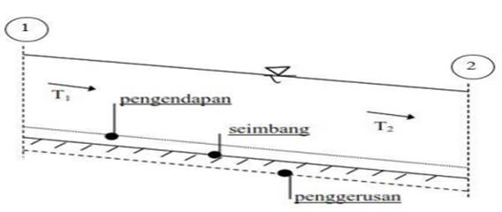
The river is said to be in a balanced state if the incoming sediment
capacity (Qin) in a longitudinal cross section of the river is equal to the
outgoing sediment capacity (Qout) in a certain time unit. Sa'ud (2008) The process of deposition in the river occurs
when the amount of incoming sediment exceeds the capacity sediment is balanced
in a certain unit of time while the erosion process in the river occurs when
the amount of incoming sediment is less than the balanced sediment capacity in
a certain time unit. Pratama et al. (2019)
Figure 1
|
Figure 1 |
Sediment Movement Mechanism
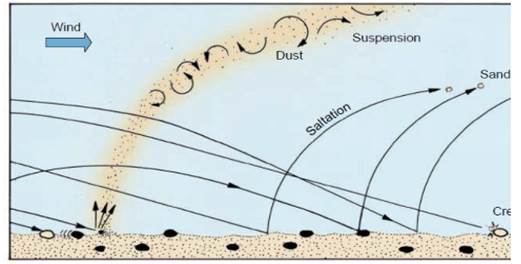
Basically, sediment grains move in the carrier medium, either in the form
of liquid or air, in 3 different ways: rolling, bouncing, and suspension.
Figure 2
|
Figure 2 |
Several methods for calculating sediment volume, namely:
1)
Duboy's . Method
The measurement of sediment transport using the Duboy's method is by the
following equation:
![]() (1)
(1)
2)
Shield's Method
The measurement of sediment transport using the Shield Aproach method is
by the following equation:
![]() (2)
(2)
3)
Yang's . Method
Which
defines the flow state such as velocity, slope product, as the basis of the
unit weight of water. To determine the total sediment concentration, Yang considered
a relevant relationship between the following variables:
![]() (3)
(3)
4)
Bagnold's Method
Bagnold (1966) developed the function and formula of
its sediment transport based on the concept of power. He considered the
relationship between the average energy available in the flow system and the
average work that had been worked together on the system during the sediment
transport process. This relationship is manifested in the equation:
qt = V![]() (4)
(4)
5)
Shen and Hung Method
Shen and Hung (1971) assumed that sediment transport wa so complex that instead of using The Reynold number,this combined Froude number
could be found to explain sediment transport under all conditions. Shen &
Hung tried to find the dominant variable that dominates the sediment transport
rate, they recommended a regression equation based on 587 sets of laboratory
data. The Shen and Hung equations can be written as follows:
Log Ct = –
107404,45938164+ 324214,74734085Y–326309,58908739Y²+ 109503,87232539 Y³ (5)
3. RESEARCH METHODOLOGY
Research
data
1)
Primary
Data: to obtain primary data, the field is carried out directly which is a
review of the location object, where this object review includes general data
collection at the location, measurement of water level, measurement of
dimensions and cross-sectional area, sediment sampling, and measurement of flow
velocity.
2)
Secondary
Data: The secondary data is taken from related agencies such as BBWSS VIII
which includes location maps and river identity data.
Data
analysis
After all the
necessary data has been collected, it is followed by processing the data to
analyze the data using a predetermined approach. In this case study, the data
will be analyzed to find the value of qb and will then analyze the volume of
sediment for the next one year. By method: Duboy's,
Shield's, Yang, Bagnold and Shen and Hung
4. RESULTS AND DISCUSSION
Based on the
results of the calculation analysis obtained the following results:
Table 1
|
Table 1 Recapitulation of Calculation Results of Qt per year on the Bendung river. |
||||
|
Section |
Metode |
Metode |
Metode |
Metode |
|
Duboy's |
Shields's |
duboy's |
Shields's |
|
|
|
(Ton/det) |
(ton/det) |
(ton/thn) |
(ton/thn) |
|
1 |
0.93911 |
0.94138 |
81.14 |
81.34 |
|
2 |
1.29397 |
1.29332 |
111.8 |
111.74 |
|
3 |
2.33981 |
2.326148 |
202.16 |
200.98 |
|
Jumlah |
4.57289 |
4.560848 |
395.1 |
394.06 |
|
Rata-rata |
1.524297 |
1.520283 |
131.7 |
131.353333 |
Table 2
|
Table 2 Recapitulation of Qd Calculation
Results on the Kedukan Bukit River. |
||||
|
No. |
Variabel |
Hasil |
Duboy's |
Shield |
|
1 |
Kecepatan Aliran |
0.287 m/s |
||
|
2 |
Luas Penampang |
14.801 m2 |
||
|
3 |
Debit Aliran |
4.247 m3/s |
||
|
4 |
Angkutan sedimen |
2.902 m3/s |
1.582x10-s m3/s |
|
Table 3
|
Table 3 Recapitulation of Qt Calculation Results per year on the Kedukan River. |
|||
|
Lokasi |
Metode |
Metode |
Metode |
|
|
yang |
Bagnold |
shen
and hung |
|
|
(ton/s) |
(ton/s) |
(ton/s) |
|
Layang |
0,0221986 |
0,0039566 |
0,0001687 |
|
Titik 1 |
0,0046215 |
0,0039087 |
0,0001844 |
|
Titik 2 |
0,0045142 |
0,0041698 |
0,0001085 |
|
Titik 3 |
0,0051918 |
0,0033109 |
0,0001363 |
|
rata-rata |
0,0091315 |
0,0038365 |
0,0001495 |
|
|
(ton/tahun) |
(ton/bulan) |
(ton/bulan) |
|
Rata-rata |
23.668,902 |
9.944,184 |
387,483 |
|
|
(ton/tahun) |
(ton/bulan) |
(ton/bulan) |
|
Rata-rata |
287.971,640 |
120.987,578 |
4.714,375 |
Table 4
|
Table 4 Recapitulation
of Qd Calculation Results on the Lambidaro River |
||||
|
No. |
Variabel |
Titik 1 |
Titik 2 |
Titik 3 |
|
1 |
Debit air (m3/dt) |
0.84 |
0.41 |
0.52 |
|
2 |
Luas Penampang(m2) |
0.22 |
0.17 |
0.25 |
|
3 |
Kecepatan Aliran(m/d) |
3.852 |
2.114 |
2.467 |
|
4 |
Angkutan sedimen |
0.000006 |
0.000003 |
0.000004 |
|
(kg/dt/m) |
|
|
|
|
Table 5
|
Table 5 Recapitulation
of Qt Calculation Results per year on the Sekanak
River. |
||
|
Metode yang digunakan |
pengerukan sedimen untuk 1 tahun lb/thn)/ft |
rata-rata qb (lb/s) ft |
|
Duboy's |
10.495,7 |
322.59 |
|
Shield's |
4.064.6 |
128.8 |
5. CONCLUSION
According to result and analysis data, we may conclude:
1) In calculating the sediment load in the Bendung river for the next one-year period, the value of
sediment transport generated using the Duboy's method
=131.67ton/yr,
Shield's method =131.35tons/yr.
2) The calculation results for the volume of floating sediment in the Kedukan river using the Duboy's method is 2,902 m³/s, while using the Shield method the floating sediment volume is 1,582 × 10️m³/s. So that the volume of floating sediment in the next year is 91,517,472 m³/s for the Duboy's method and 498.89952 m³/s for the Shield method.
3)
The total sediment transport discharge in
the Sekanak
riverr 0.0091315 ton/sec for Yang method, for the Bagnold method = 0.0038365
tons/sec and for the Shen and Hung method = 0.0001495 tons/sec.
4)
By
calculating using the shield method, the average sediment results that occur in
the Lambidaro River in Palembang City in the next one
year is equal to136.656 kg/yr/m
5) Based on the result of the analysis of calculation and recapitulation in the Sekanak River, it can be concluded that by using 2 approaches, the results for calculating the volume of sediment in the Sekanak River are the Duboy's Method. The average qb sediment yield is 322.59 (lb/s)/ft, Volume is 10,495, 7 (lb/yr)/ft. Shield's Method Average yield of qb sediment is 128.8 (lb/s)/ft, Volume is 4,064.6 (lb/yr)/ft.
CONFLICT OF INTERESTS
None.
ACKNOWLEDGMENTS
None.
REFERENCES
Anasiru, Triyanti (2006). "Sediment Transport at the Palu River Estuary." SMARTek 4(1), 25-33.
Bella, Resnie (2014). “ (Bed Load) At the Lilin River Estuary, Musi Regency - Banyuasin." Journal of Civil and Environmental Engineering 2(1), 225-230.
Iskandar, Rina et al. (2013). "Study of Sedimentation in the Angsana River Estuary, Angsana District, Tanah Bumbu Regency, South Kalimantan." EnviroScienteae 9,106-11.
Kimi, Sudirman, and Sri Martini (2017). "Analysis of Calculation of Sediment Loads in the 1000 Meters of Baung River." 5(1), 69-75.
Mulyanto, HR (2007). River Functions and Its Properties. Yogyakarta, Graha Ilmu.
Pangestu, Hendar, and Helmi Haki (2013). "Analysis of Total Sediment Transport in the Dawas River, Musi Banyuasin Regency." Journal of Civil and Environmental Engineering 1(1), 23.
Pratama, Muhammad Iqbal, Djoko Legono, and Adam Pamudji Rahardjo (2019). "Mining Activities on the Sombe River, Palu City, Central Sulawesi." Watering Techniques (90), 84-96. https://doi.org/10.21776/ub.pengairan.2019.010.02.02
Sa'ud, Ismail (2008). "Prediction of Kali Mas Surabaya Sedimentation." Journal of Civil Engineering Applications 4(1), 20. https://doi.org/10.12962/j12345678.v4i1.2765
Salsabila, Annisa, and Irma Lusi Nugraheni (2020). "Introduction to Hydrology."
Sembiring, Amelia Ester, T Mananoma, F Halim, and EM Wuisan (2014). "Analysis of Sedimentation at the Estuary of the Panasen River." Journal of Civil Statistics 2(3), 148-54.
Sri Martini, RA, Zainul Bahri, and Ade Tricia Miranda (2020). "The Effect of Flow Discharge on Sedimentation in the Lematang River, Lahat Regency." Bearing : Journal of Civil Engineering Research and Studies 6(3), 188-93. https://doi.org/10.32502/jbearing.2841202063
|
|
 This work is licensed under a: Creative Commons Attribution 4.0 International License
© IJETMR 2014-2022. All Rights Reserved.