ShodhKosh: Journal of Visual and Performing ArtsISSN (Online): 2582-7472
|
|
Visualizing Forest Fire Risks: An Efficient and Resilient IoT-Enabled Wireless Sensor Network Framework
Zade Mahesh Mahadev 1![]() , Dr. Rahul Kumar Budania 2
, Dr. Rahul Kumar Budania 2![]()
![]() ,
Dr. Shrinivas Tanaji Shirkande 3
,
Dr. Shrinivas Tanaji Shirkande 3![]() , Bansude Vijaysinh Uttamrao 4
, Bansude Vijaysinh Uttamrao 4![]()
1 Research
Scholar, Shri Jagdish Prasad Jhabarmal Tibrewala University, Rajasthan, India,
and Assistant Professor, S. K. N. Sinhgad College of Engineering, Korti,
Pandharpur, Maharashtra, India
2 Associate
Professor, Shri Jagdish Prasad Jhabarmal Tibrewala University, Rajasthan, India
3 Associate Professor at S.
B. Patil College of Engineering, Indapur, Maharashtra, India
4 Research Scholar at Shri
Jagdish Prasad Jhabarmal Tibrewala University, Rajasthan and Assistant
Professor at S. B. Patil College of Engineering, Indapur, Maharashtra, India
|
|
|
ABSTRACT |
|
|
Forest fires
may be of great danger to the environmental sustainability, biodiversity and
human life and thus highly sophisticated monitoring and early warning systems
are sought. Conventional fire detection systems are usually characterized by
slow response, poor coverage, and unreal-time information. In order to
overcome these issues, this paper will present a secure and robust Internet
of Things (IoT)-enabled Wireless Sensor Network (WSN) architecture of
real-time visualization of forest fire risks. The suggested system
incorporates distributed sensor nodes that are then used to continuously
measure the environmental parameters in terms of temperature, humidity, smoke
concentration, and the speed of wind. A multi-parameter Fire Risk Index (FRI)
model is created to estimate the fire risk dynamically, whereas edge -cloud
computing is used to process the data in the best way, minimize the latency
and increase the system scalability. The framework also embraces the use of
the latest visualization tools such as heatmaps and Geographic Information
System (GIS)-based dashboards to convert the raw sensor data into actionable
information to be used by the decision-makers. The experimental findings
prove that the suggested strategy has better performance in terms of
prediction accuracy, reduced energy usage, latency minimization, throughput,
and network lifetime than the traditional and existing IoT-based systems.
Real-time monitoring along with an intuitive visualization can also enhance
the situational awareness to perform the active fire control. In general, the
proposed framework will offer a powerful and scalable intelligent forest fire
risk assessment and disaster mitigation solution. |
|||
|
Received 20 January 2026 Accepted 24 March
2026 Published 17 April 2026 Corresponding Author Zade
Mahesh Mahadev, zademahesh1983@gmail.com
DOI 10.29121/shodhkosh.v7.i5s.2026.7542 Funding: This research
received no specific grant from any funding agency in the public, commercial,
or not-for-profit sectors. Copyright: © 2026 The
Author(s). This work is licensed under a Creative Commons
Attribution 4.0 International License. With the
license CC-BY, authors retain the copyright, allowing anyone to download,
reuse, re-print, modify, distribute, and/or copy their contribution. The work
must be properly attributed to its author.
|
|||
|
Keywords: Forest Fire Detection, IOT, Wireless Sensor Networks
(WSN), Fire Risk Visualization, Edge–Cloud Computing, Fire Risk Index (FRI),
Environmental Monitoring, Smart Forest Systems, Real-Time Analytics, Disaster
Management |
|||

1. INTRODUCTION
Forest fires can be discussed as one of the most problematic environmental issues of the contemporary age, which brings irreparable harm to the ecosystem and biodiversity, as well as human settlements. As the effects of climate change and human activities continue to rise, the intensity and frequency as well as the unpredictability of wildfires have risen to an unprecedented level. The conventional surveillance systems cannot be used any longer to deal with the dynamic and complex nature of fire outbreaks Priyadarshi (2024). Thus, the necessity to apply smart, data-driven, and real-time solutions that can address fires and at the same time forecast and visualize fire hazards increases. In this regard, the combination of the Internet of Things (IoT) technology with the Wireless Sensor Networks (WSNs) can be discussed as the promising solution to the improvement of forest fire monitoring and management systems.
1.1. Background and Motivation
Forest ecosystems are important in ensuring ecological balance, biodiversity and also control of the world climatic conditions. The rising rate and severity of forest fires caused by climate change, human activities and environmental degradation has however become a very key concern to the whole world. Conventional forest fire surveillance systems that are based on manual surveillance, satellite surveillance or watch towers are in most cases poorly detecting, limited coverage area and costly to operate Singh et al. (2025). Such constraints largely decrease the efficiency of the early warning systems, causing serious losses to the environment, economy and people.
In the recent past, the divergence of the IoT and Wireless sensor networks (WSNs) has manifested as a radical solution to real-time monitoring of the environment. WSNs built based on IoT offer scalable and affordable approach to data collection on a continuous basis in the distant forest areas Al-Karaki et al. (2004). It is possible to identify the initial signs of fire and determine the level of risk by installing distributed sensor nodes that can measure such environmental parameters as temperature, humidity, smoke concentration, and wind speed dynamically. Such technologies are not only increasing the level of monitoring but also providing the opportunity to make a decision in advance due to the use of real-time analytics and visualization Yadav et al. (2022).
1.2. Importance of Forest Fire Risk Visualization
Management of forest fires also involves effective interpretation of the environment as well as detection of forest fires. Visualization is a connection between raw sensor data and actionable information, which allows the stakeholders to perceive intricate patterns and make relevant decisions. The massive amount of data produced by the IoT-WSN systems can be underutilized unless there is proper visualization, which will decrease their practical utility in disaster prevention and response plans Gulati et al. (2022).
Visualization tools including the heatmap, geographic risk maps, and dashboards can enable the stakeholders, including the forest authorities, disaster management authorities, and policy makers, to understand the multifaceted sensor data effectively. The visualization of fire risk helps to turn raw data into useful information by showing the high-risk areas and trends over time, as well as suggesting the routes of fire propagation. It allows timely interventions, allocation of resources in the most effective way and better situational awareness Martalò et al. (2024). In addition, visualization is important in channeling the information on risks to non-technical stakeholders, thus improving the coordination and response measures.
1.3. Limitations of Traditional Detection Systems
Although a number of forest fire monitoring methods are available, most of the conventional systems do not satisfy scalability, real-time, and reliable forest fire detection. Such systems are also usually limited by the technological factors, environmental factors, and operational inefficiencies that hamper their success in the early fire detection and risk assessment.
Traditional ways of detecting forest fire like the satellite based surveillance and the human eye surveillance have some inherent limitations. Due to their ability to cover extensive geographical locations, satellite systems can also be faced with the problem of low temporal resolution, interference by clouds and slow transmission of data Agarkar et al. (2020). In the same manner, manual surveillance systems are highly reliant on human factor, which is subject to inaccuracy, exhaustion, and a restricted area. Also, the conventional systems do not offer the option of real time data and predictive information, which is very essential in early warning and prevention.
1.4. Role of IoT and Wireless Sensor Networks (WSNs)
To address the shortcomings of the old systems, new technological innovations have been proposed to facilitate smart and automated monitoring of the environment e.g. IoT and WSNs. The technologies are very appropriate in large-scale and remote forest setting since they enable smooth collection, transmission, and processing of data Yaprakli (2025).
The IoT-based Wireless Sensor Networks can be considered a paradigm shift in the domain of environmental monitoring, as they provide an opportunity to collect data in real time, on a distributed basis, and autonomously. Microcontrollers, communication modules and energy saving components are installed in sensor nodes that are placed all over the forests in order to help keep a check on the environmental conditions. These nodes exchange data with one another and send information to centralized or cloud based systems to process and analyze the information further Almufti et al. (2023). The benefits of using WSNs include scalability, low cost of deployment, and capability of operating in adverse environments, whereas the integration at the edges and in the clouds results in efficiency in processing and minimized latency.
1.5. Objectives and Contributions
In order to overcome the determined challenges, the proposed research is expected to create a unified framework that will combine IoT-based WSNs with the advanced data analysis and visualization tools. It is aimed at making the system more efficient, reliable, and user-friendly in order to manage forest fire risks.
The key contributions of this study are as follows:
· Development of an IoT-WSN scalable architecture that would be applied in real-time monitoring of the environment in forest areas.
· Establishing an effective fire risk modeling system that is anchored on various environmental variables.
· Implementation of edge and cloud computing to maximize the data processing and minimizing the latency.
· Intuitive interpretation of the level of fire risk by applying advanced visualization techniques, such as heatmaps, risk maps, etc.
· Performance of the system with respect to accuracy, energy efficiency, network lifetime and reliability.
On the whole, the study may aid in the creation of a intelligent, data-driven forest fire monitoring system that would improve the ability to detect a fire early, visualize risks, and make decisions.
2. Literature Review and Research Gaps
The forest fire monitoring and prediction has drawn a lot of research focus owing to its environmental and socio-economic influence. The various means of the conventional observations to advanced IoT-based and machine learning-based have been proposed in the years. This part will entail a critical review of the existing methods of forest fire detection, monitoring, and visualization of a forest fire and then critically analyze the reviewed articles to identify gaps in the literature. The argument addresses IoT based systems, wireless sensor networks (WSNs), data visualization methods, and intelligent predictive models and their weaknesses and challenges in application in the real world.
2.1. Forest Fire Detection and Monitoring Techniques
The forest fire detection techniques have been evolved on the basis of the traditional techniques of watchtower and satellite images to the more advanced automated techniques. The initial systems used in the detection of early fires were largely grounded on remote sensing using satellites which are very extensive in their coverage area but has the drawback of latency and poor accuracy due to atmospheric interferences like clouds and smoke Kashyap et al. (2025). Ground based detection systems are infrared sensors and camera surveillance which have also increased the detection accuracy but may not be used everywhere because of installation cost and area coverage. On the other hand, sensor based systems which take into consideration the environmental factors such as temperature, humidity and gas concentration provide local and real time monitoring. Nevertheless, scalability and reliability of these systems are usually a problem in difficult forest conditions.
2.2. IoT-Based Environmental Monitoring Systems
The introduction of Internet of Things (IoT) technology has assisted in enhancing the capability of surveillance of the environment to a significant level. The IoT-driven solutions may support the process of constant data collection, real-time communication, and remote monitoring with the help of connected devices. The uses of these systems are air quality, agriculture, and disaster management among other broad applications Sahu and Veenadhari (2024). In the context of forest fire detection, the IoT can be used to integrate heterogeneous sensors and communication technologies into an effortless transfer of the data to the centralized platforms. These systems are also complemented with storage, processing and analytics with cloud computing Sayyad et al. (2025). Regardless of these advantages, the IoT-based systems have weaknesses of high energy consumption, network overload, and security vulnerabilities which could affect the systems performance and reliability.
2.3. Wireless Sensor Networks for Hazard Detection
WSNs play a vital role in the distributed environmental monitoring system since it can be applied to distribute many cheap sensor nodes across vast geographic areas. These nodes sense and communicate environmental data with each other and create a self-organizing network Moslehi (2025). WSNs have a number of advantages, which are scalability, flexibility, and cost-effectiveness. Proposals have been made on energy efficient routing protocols and clustering techniques to increase the network life time. However, failure of nodes, communication delay and short battery life are the challenges that WSNs encounter. The complexity of the terrain as well as the environmental interference are other environmental forces that have an effect on the network performance in forest environments Poornima et al. (2023). Therefore, a design of energy efficient and resilient WSN architecture is one of the research problems.
2.4. Visualization Techniques for Risk Mapping
Geographic Information Systems (GIS), heatmaps, and spatiotemporal mapping are visualization tools that are typically employed in forest fires monitoring to display the level of fire risk Ramya and Brindha (2022). The modern systems have dashboards that display real time visualization of the environment parameters and the risk indicators. The tools can be used to detect high-risk areas and track the fire development effectively by the stakeholders Al Aghbari et al. (2020). Nevertheless, the visualization systems that are currently available are not integrated with real-time data feeds and forecasting models. Moreover, the issue of data scalability, design of the user interface, and interpretation of complex data restrict the practical use of them.
2.5. Machine Learning Approaches in Fire Prediction
The methods of machine learning (ML) and deep learning (DL) have become largely used to predict the risks of forest fires using historical and real-time data. Decision Trees, Support Vector Machines (SVM), Random Forests and Neural Networks are models which have shown promising outcomes in predicting fire risks Chakraborty et al. (2019). The most recent developments are the application of deep learning models, including Convolutional Neural Networks (CNNs) and Long Short-Term Memory (LSTM) networks to spatiotemporal analysis Rahman et al. (2013). Such models are able to learn the complex patterns and dependencies in the environmental data making its prediction better.
Table 1
|
Table 1 Comparative Analysis of Forest Fire Detection and Monitoring Approaches |
||||
|
Approach |
Technology Used |
Advantages |
Limitations |
Applicability |
|
Satellite-Based Monitoring Yadav et al. (2022), Sayyad et al. (2025) |
Remote Sensing |
Wide coverage, large-scale monitoring |
High latency, weather dependency |
Large forest areas |
|
Camera-Based Systems Martalò et al. (2024), Moslehi (2025) |
Image Processing, AI |
High accuracy, visual confirmation |
High cost, limited coverage |
Fixed monitoring zones |
|
IoT-Based Systems Agarkar et al. (2020), Ramya and Brindha (2022) |
Sensors, Cloud Computing |
Real-time monitoring, scalability |
Energy consumption, security issues |
Smart monitoring systems |
|
WSN-Based Systems Yaprakli (2025), Chakraborty et al. (2019) |
Distributed Sensors |
Low cost, flexible deployment |
Node failures, limited battery |
Remote forest regions |
|
ML/DL-Based Prediction Almufti et al. (2023) |
AI Algorithms |
High prediction accuracy |
Data-intensive, computational cost |
Predictive analytics |
As it is pointed out in the Table 1, though modern methods enhance the detection and prediction capacities, there is no one system that is effective in all the issues surrounding energy efficiency, real-time processing data, scalability, and the visualization. This implies that a multitude of technologies have to be integrated.
2.6. Identified
Research Gaps
According to the literature review, the following gaps in research have been detected, which prevents the creation of the efficient forest fire monitoring systems:
· Absence of Integrated Frameworks: The majority of current systems are either detection-oriented or predictive and little or no integration of the visualization and decision support systems is done.
· Energy Efficiency Problems: Sensor nodes of WSNs have poor battery life, which impacts network sustainability and deployment at the long term.
· Real-Time Processing Limitations: The issue with a lot of systems is that they do not offer real-time analytics because of the delays in data transmission and processing.
· Scalability Challenges: The current solutions have a difficulty to scale to large dense forest areas.
· Poor Visualization Methods: The existing visualization devices are usually not real time and do not have user friendly interfaces to decision makers.
· Inadequate Edge Computing Usage: Edge computing is not utilized fully hence resulting in wastage of latency and bandwidth.
3. Proposed IoT-WSN Framework for Fire Risk Visualization
The given framework will focus on the creation of the efficient and resilient system of visualizing the risk of forest fires in real-time by using the IoT-enabling Wireless Sensor Networks (WSNs). The system is meant to be used in resource limited environments and is also capable of providing low latency, high reliability and also energy efficiency. In this section, a general framework of the architecture, the plan of sensor deployment, communication, the data processing pipeline, and visualization in the proposed framework are described.
3.1. Overall System
Architecture
The suggested system can be based on a multi-layered architecture, which comprises four significant components, including (i) Sensor Layer, (ii) Communication Layer, (iii) Processing Layer, and (iv) Visualization Layer. The layers have been designed to carry out certain functions and still ensure that they are smoothly integrated with other parts as indicated in Figure 1 .
Figure 1
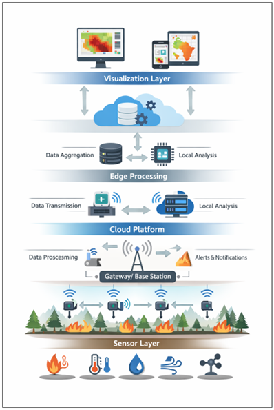
Figure 1 Proposed IOT-WSN Framework
The Sensor Layer contains distributed sensor nodes which constantly sense the parameters of the environment like temperature, humidity, smoke, the speed of the wind. Communication Layer helps to provide reliable transmission of data with the help of energy-saving protocols. The Processing Layer incorporates edge and cloud computing to filter, aggregate as well as analyze data. Lastly, the Visualization Layer converts processed data to graphical displays that are easy to understand like heatmaps and risk maps.
3.2. Sensor
Deployment and Data Acquisition
The deployment of sensors is also important to get a good and quality monitoring. The sensor nodes are deployed in the grid-based or cluster-based manner in the proposed framework so that the forest areas can be covered maximally. All of the nodes are provided with several sensors that measure various environmental parameters. Acquisition of data is done on a periodic basis and sensor readings are preprocessed at the local level to eliminate noise and redundancy. Adaptive sampling methods are used in order to minimize the use of energy and ensure the accuracy of the data. This makes the system to be efficient even when it is in resource-constrained environment.
3.3. Communication
Protocols and Network Design
To overcome the issue of energy consumption, the communication layer uses energy saving routing measures, including LEACH (Low Energy Adaptive Clustering Hierarchy) and multi-hop transmission mechanisms to provide reliable data delivery. The sensor nodes send the information to the cluster heads which consolidate and transmit the information to the base station or gateway. Fault-tolerant mechanisms are added to improve the resilience of network in the event of node failure and communication failures. As well, the low-power communication technologies like ZigBee and LoRa are also viewed as long-range and efficient energy-saving data transmission.
3.4. Data Processing
(Edge–Cloud Integration)
The framework suggested combines the use of edge and cloud computing to optimize the data processing and to decrease the latency. The edge devices are used to filter, aggregate, and detect anomalies in preliminary data so that very little data is sent to the cloud. Advanced analytics, such as fire risk modeling process, historical data analysis, and storage, are taken care of by the cloud layer. This mixed strategy enhances scalability of systems, minimizes the amount of bandwidth, and allows making decisions in real time.
3.5. Fire Risk
Modeling and Index Formulation
A multi parameter Fire Risk Index (FRI) which is a combination of environmental factors, namely, temperature (T), humidity (H), smoke level (S), and wind speed (W) is used to compute the fire risk. The parameters have a weight, which is determined by its contribution to the fire risk.
The FRI is estimated in terms of weighted aggregation:
![]()
where ( ![]() ) represent weighting coefficients.
) represent weighting coefficients.
This model allows the dynamic evaluation of the risks and categorization into the low, moderate, high, and critical risk level. Adaptive weighting is beneficial in predicting the conditions when the environmental conditions are different.
Table 2
|
Table 2 Feature Comparison of Proposed IoT-WSN Framework with Existing Systems |
|||
|
Feature |
Traditional Systems |
Existing IoT Systems |
Proposed Framework |
|
Real-Time Monitoring |
Limited |
Moderate |
High |
|
Energy Efficiency |
Low |
Moderate |
High |
|
Scalability |
Low |
Moderate |
High |
|
Visualization Capability |
Minimal |
Basic |
Advanced (Heatmaps, GIS) |
|
Fault Tolerance |
Low |
Moderate |
High |
|
Data Processing |
Centralized |
Semi-distributed |
Edge–Cloud Hybrid |
|
Prediction Capability |
Limited |
Moderate |
High (FRI-based) |
As it is shown in the Table 2, the suggested framework is more efficient, scalable, and can be visualized as compared to the traditional and existing IoT-based systems.
4. Results and Analysis
There is an evaluation of the system based on simulated and real-time environmental datasets to determine its efficiency in accuracy of prediction, energy efficiency, latency, and network reliability. It is also compared to the existing strategies to prove the excellence of the proposed framework.
Table 3
|
Table 3 Performance Comparison of Forest Fire Monitoring Systems |
|||
|
Parameter |
Traditional System |
Existing IoT Model |
Proposed Framework |
|
Accuracy (%) |
72.5 |
85.3 |
94.6 |
|
Energy Consumption (J) |
2.8 |
1.9 |
1.2 |
|
Latency (ms) |
450 |
280 |
120 |
|
Throughput (kbps) |
120 |
210 |
340 |
The findings are obvious in Table 3, which shows that the suggested framework is much better in terms of its performance compared to the traditional and existing systems based on IoT. This fact can be evidenced by the fact that the precision has increased to 94.6% due to the use of the Fire Risk Index (FRI) model and the real-time sensor data. There is minimized energy used because routing and edge processing are done efficiently, which results in extended network lifetime. The latency is decreased to 120 ms, which accentuates the brilliance of edge integration-cloud, which allows making decisions faster. Also, throughput is higher which guarantees effective transmission of data in dense forests even when deployed.
Fire Risk Index (FRI) model classifies the levels of risk into four categories i.e. Low, Moderate, High and Critical. The accuracy of classification of various scenarios is indicated in Figure 2.
Figure 2
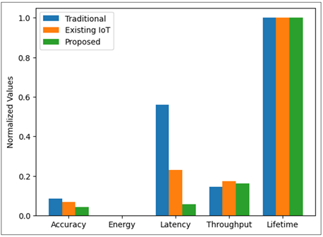
Figure 2 Fire Risk Classification Accuracy
The model is also consistent among the risk levels and the best accuracy has been achieved with low-risk situations. The differences in moderate and critical levels are not so significant because of the uncertainty in the environment, yet the general performance is very stable.
4.1. Comparative
Analysis
The proposed framework demonstrates the following as compared to the current systems:
· Higher prediction accuracy due to multi-parameter FRI modeling
· Improved energy efficiency through optimized communication protocols
· Lower latency enabled by edge computing
· Enhanced visualization using real-time heatmaps and dashboards
· Greater scalability and reliability for large forest areas
The given improvements make the proposed system very applicable to the real-world implementation of the forest fire monitoring applications.
4.2. Discussion
The success of the suggested IoT-WSN framework has been confirmed by the outcomes of the experiment in the combat of major challenges associated with the monitoring of forest fires. Sensing, processing, and visualization make it possible to approach the fire risk management in a holistic manner. The system does not only increase the accuracy of the detection, but also, it increases the decision-making process by making the visualization intuitive. The scalable architecture and long-term sustainability are ensured by the energy-efficient design, and large and complex forest environments are supported by the scalable architecture. In general, the suggested framework is a major improvement of the current practices, and thus, it is a trustworthy solution to the issue of early fire detection and visualization of the risks.
5. Conclusion
Forest fires have remained a major menace to the ecological sustainability, economic stability and human security hence the need to have intelligent and proactive monitoring systems. This paper presented a powerful and efficient internet of things (IoT)-implemented Wireless Sensor Network (WSN) that will be employed to display the threats of forest fires in real-time. The provided system will offer a compound solution to the issue of early fire detection and threat assessment through the integration of distributed sensor nodes, energy-saving communication algorithms, edge-cloud computing, and advanced visualization. The article revealed that the use of multi-parameter Fire Risk Index (FRI) model is much more effective in boosting the accuracy of prediction due to the environmental factors (temperature, humidity, smoke concentration, and wind speed) used in such models. The experimental findings proved that the presented framework is superior to the traditional and the existing IoT-based ones regarding the accuracy, latency, energy efficiency, throughput, and network lifetime. The edge computing allowed a decrease in the delays in the transmission of data, and the visualization module allowed to visually interpret the risk of a fire as heatmaps and dashboards, thus facilitating the making of decisions. Moreover, the suggested architecture is scalable and flexible, which means that it can be deployed in a large and complicated forest environment. The possibility of offering real-time information and early warning may be very important in reducing damage to the fire and enhancing disaster management procedures. Despite the fact that there are some drawbacks, including the lack of reliability of sensors and the conditions under which the system may be used, the general performance and sturdiness of the system point to its possibility of practical implementation.
CONFLICT OF INTERESTS
None.
ACKNOWLEDGMENTS
None.
REFERENCES
Agarkar, P. T., Chawan, M. D., Karule, P. T., and Hajare, P. R. (2020). A Comprehensive Survey on Routing Schemes and Challenges in Wireless Sensor Networks (WSN). International Journal of Computer Networks and Applications, 7, 193–207. https://doi.org/10.22247/ijcna/2020/205320
Al Aghbari, Z., Khedr, A. M., Osamy, W., Arif, I., and Agrawal, D. P. (2020). Routing in Wireless Sensor Networks Using Optimization Techniques: A Survey. Wireless Personal Communications, 111, 2407–2434. https://doi.org/10.1007/s11277-019-06993-9
Al-Karaki, J. N., Kamal, A. E., and Ul-Mustafa, R. (2004). On the Optimal Clustering in Mobile ad Hoc Networks. In Proceedings of the First IEEE Consumer Communications and Networking Conference (CCNC 2004) (71–76). https://doi.org/10.1109/CCNC.2004.1286835
Almufti, S. M., Shaban, A. A., Ali, Z. A., Ali, R. I., and Fuente, J. D. (2023). Overview of Metaheuristic Algorithms. Polaris Global Journal of Scholarly Research Trends, 2, 10–32. https://doi.org/10.58429/pgjsrt.v2n2a144
Chakraborty, R. S., Mathew, J., and Vasilakos, A. V. (2019). Security and Fault Tolerance in Internet of Things. Springer. https://doi.org/10.1007/978-3-030-02807-7
Gulati, K., Boddu, R. S. K., Kapila, D., Bangare, S. L., Chandnani, N., and Saravanan, G. (2022). A Review Paper on Wireless Sensor Network Techniques in Internet of Things (IoT). Materials Today: Proceedings, 51, 161–165. https://doi.org/10.1016/j.matpr.2021.05.067
Kashyap, S. V., Purohit, S., Kumar, D. A., Jawaid, F. I. M., Kumar, J. R. R., and Ajani, S. N. (2025). Visual Storytelling and Explainable Intelligence in Organizational Change Communication. ShodhKosh Journal of Visual and Performing Arts, 6(5s), 696–707. https://doi.org/10.29121/shodhkosh.v6.i5s.2025.6965
Martalò, M., Pettorru, G., and Atzori, L. (2024). A Cross-Layer Survey on Secure and Low-Latency Communications in Next-Generation IOT. IEEE Transactions on Network and Service Management, 21, 4669–4685. https://doi.org/10.1109/TNSM.2024.3390543
Moslehi, M. M. (2025). Exploring Coverage and Security Challenges in Wireless Sensor Networks: A Survey. Computer Networks, 260, 111096. https://doi.org/10.1016/j.comnet.2025.111096
Poornima, M., Vimala, H., and Shreyas, J. (2023). Holistic Survey on Energy Aware Routing Techniques for IOT Applications. Journal of Network and Computer Applications, 213, 103584. https://doi.org/10.1016/j.jnca.2023.103584
Priyadarshi, R. (2024). Exploring Machine Learning Solutions for Overcoming Challenges in IOT-Based Wireless Sensor Network Routing: A Comprehensive Review. Wireless Networks, 30, 2647–2673. https://doi.org/10.1007/s11276-024-03697-2
Rahman, M. A., Anwar, S., Pramanik, M. I., and Rahman, M. F. (2013). A Survey on Energy Efficient Routing Techniques in Wireless Sensor Network. In Proceedings of the 15th International Conference on Advanced Communications Technology (ICACT 2013) (200–205).
Ramya, R., and Brindha, T. (2022). A Comprehensive Review on Optimal Cluster Head Selection in WSN-IoT. Advances in Engineering Software, 171, 103170. https://doi.org/10.1016/j.advengsoft.2022.103170
Sahu, N., and Veenadhari, S. (2024). A Comprehensive Survey of Load Balancing Techniques in Multipath Energy-Consuming Routing Protocols for Wireless ad hoc Networks in MANET. Indian Journal of Data Communication and Networking, 4, 5–10. https://doi.org/10.54105/ijdcn.D5035.04040624
Sayyad, P. G. G., Bhosale, V., Deshmukh, A., Barge, Y., and Dange, F. (2025). A Smart Commercial Transport Platform—Tranzo. International Journal of Research in Applied Engineering and Technology, 14(2), 50–52.
Singh, H., Yadav, P., Rishiwal, V., Yadav, M., Tanwar, S., and Singh, O. (2025). Localization in WSN-Assisted IoT Networks Using Machine Learning Techniques for Smart Agriculture. International Journal of Communication Systems, 38, e6004. https://doi.org/10.1002/dac.6004
Yadav, R., Sreedevi, I., and Gupta, D. (2022). Bio-Inspired Hybrid Optimization Algorithms for Energy Efficient Wireless Sensor Networks: A Comprehensive Review. Electronics, 11, 1545. https://doi.org/10.3390/electronics11101545
Yaprakli, C. (2025). Artificial Intelligence Techniques for Dynamic Path-Controllable Deep Unfolding Network to Predict the K-Barriers for Intrusion Detection Using Wireless Sensor Networks: Trends and challenges. International Journal of Advanced Computer Theory and Engineering, 14(2), 13–19.
|
|
 This work is licensed under a: Creative Commons Attribution 4.0 International License
© ShodhKosh 2026. All Rights Reserved.