ShodhKosh: Journal of Visual and Performing ArtsISSN (Online): 2582-7472
|
|
Using Drone-Based Cinematography to Expand Aesthetic Possibilities in Landscape Visual Arts
Dr. Satya Ranjan Das 1![]()
![]() ,
Ankit Punia 2
,
Ankit Punia 2![]()
![]() ,
Chandrashekhar Ramesh Ramtirthkar 3
,
Chandrashekhar Ramesh Ramtirthkar 3![]() , Shanthi P. 4
, Shanthi P. 4![]() , Yang Lu 5
, Yang Lu 5![]()
![]() ,
Pavan P. S. 6
,
Pavan P. S. 6![]()
![]()
1 Associate
Professor, Department of Computer Science and Engineering, Institute of
Technical Education and Research, Siksha 'O' Anusandhan (Deemed to be
University), Bhubaneswar, Odisha, India
2 Centre
of Research Impact and Outcome, Chitkara University, Rajpura- 140417, Punjab,
India
3 Associate Professor, Department of Mechanical Engineering,
Vishwakarma Institute of Technology, Pune, Maharashtra 411037, India
4 Assistant Professor, Visual Communication, Meenakshi College of Arts
and Science, Meenakshi Academy of Higher Education and Research, Chennai, Tamil
Nadu 600080, India
5 Faculty of Education Shinawatra University, Bang Toei, Thailand
6 Assistant Professor, Department of Civil Engineering, Faculty of
Engineering and Technology, JAIN (Deemed-to-be University), Bengaluru,
Karnataka, India
|
|
|
ABSTRACT |
|
|
The emergence
of drone-based cinematography has tremendously widened the aesthetic
potential of landscape visual arts, allowing the perspectives and visual
compositions otherwise challenging or inaccessible to photography or
filmmaking methodologies on the ground. The paper explores the use of aerial
imaging technologies in the artistic expression and spatial perception and
the visual narrative of landscape art. The study investigates the effects of
aerial perspective on the conventional compositional principles of the scale,
symmetrical development, motions, and environmental context, by discussing
theoretical grounds of visual aesthetics and spatial perception. The research
paper follows a qualitative and practice-based approach to research based on
the analysis of chosen landscape settings and artistic situations with the
help of the drone systems with high-resolution cameras and stabilizing gimbal
systems. The study analyzes the role of the change in altitude, camera
movement, and dynamic framing in providing new aesthetic values of landscape
representation. Also, the study focuses on the business issues such as
regulatory limitations, environmental effects, and privacy concerns related
to the use of drones in artistic production. According to the findings, drone
cinematography can greatly increase visual diversity allowing artists to
design immersive aerial shots, uncover concealed geographical formations, and
introduce new narrative forms to landscape visual arts. |
|||
|
Received 19 January 2026 Accepted 23 March
2026 Published 11 April 2026 Corresponding Author Dr. Satya
Ranjan Das, satyadas@soa.ac.in DOI 10.29121/shodhkosh.v7.i4s.2026.7489 Funding: This research
received no specific grant from any funding agency in the public, commercial,
or not-for-profit sectors. Copyright: © 2026 The
Author(s). This work is licensed under a Creative Commons
Attribution 4.0 International License. With the
license CC-BY, authors retain the copyright, allowing anyone to download,
reuse, re-print, modify, distribute, and/or copy their contribution. The work
must be properly attributed to its author.
|
|||
|
Keywords: Drone Cinematography, Landscape Visual Arts, Aerial
Perspective, Visual Composition, Digital Aesthetics |
|||


1. INTRODUCTION
Landscape visual arts have been historically an imperative source of interpreting and representing the natural environment by artists. The classical landscape paintings through modern photography and cinema production have provided artists with an unending quest of new techniques and technologies to express the beauty, the scale and the emotional appeal of the natural landscapes. The classical modes of visual art, which include ground photography, painting and fixed camera shot cinematography, mostly offer horizontal views that focus on foregrounds and linear depth. Although these techniques have created many iconic pieces of landscape art, they necessarily restrict the viewer to seeing spatial relationships, environmental patterns and large geographic structures of a geographic area Guan et al. (2022). The recent technological achievement in aerial photography has also brought in new opportunities in artistic portrayal, especially when unmanned aerial vehicles (UAVs) or drones are involved. Cinematography through the use of drones allows artists and filmmakers to shoot landscapes at a higher point thus providing dynamic points of view that are wider than the traditional point of view of ground level. Drones enable the creators to explore new compositional methods and patterns, textures and spaces of landscapes that would be challenging to see by offering the flexibility of camera placement, fluid motion of the camera, and spatial control Sun et al. (2021). The adoption of the drone technology in visual art has completely changed the manner in which landscapes are captured and understood. The aerial cinematography helps to explore the vertical space, which allows the panorama, the top-down shots and the free flow of the camera, which is used to enrich the visual story of a location. These features enable artists to highlight geometric patterns in agricultural lands, focus on natural feature like rivers, mountains and coastline, and also record expansive environmental interactions between nature and the built surroundings. Due to this, drone cinematography broadens the aesthetic language that visual artists have at their disposal, which allows new types of creative experimentation and narrative Librán-Embid et al. (2020).
Moreover, drone visual practices overlap with theoretical issues in visual perception, spatial aesthetics and motion picture composition. Aerial perspectives are opposing the traditional compositional rules and principles as they change the sense of scale, direction, and spatial hierarchy of the viewer. The higher viewpoint enables artists to work out visual balance, symmetry and movement within a picture and produce compositions which accentuate abstraction and structure of the environment and dynamic spatial relationships. These properties render drone cinematography especially useful to landscape visual arts, in which the visualization of the complexity and the expansiveness of natural settings frequently becomes the subject of artistic expression Dronova et al. (2021). Although the use of a drone technology in artistic practice is gained in popularity, it raises multiple practical and ethical concerns as well. Legal limitations on drone activity are different in different jurisdictions and can restrict filming in sensitive zones or those exhibiting a high population density. Moreover, issues regarding environmental disruption, protection of wildlife, and privacy should be properly considered when the drones are employed in the creative production. Aerial cinematography can also be affected by technical considerations like battery life, weather conditions and stabilization limitations which can affect the quality and feasibility of the filming Cao et al. (2023). With these possibilities and challenges, this paper looks at the ways of using drone-based cinematography in widening the aesthetic capabilities of landscape visual arts. Through the discussion of theoretical underpinnings of landscape aesthetics, photographic compositional strategies in aerial photography, and practical issues in the use of drone technologies in the work of visual art, the research will offer a conceptual framework of the transformative nature of aerial technologies in modern visual art practices Mohsan et al. (2022).
2. Related Work
The use of the aerial imaging technology in visual arts and cinematography has received growing scholarly interest in the last ten years. The previous investigations into landscape representation mostly dealt with the old forms of representation including painting, photography, and ground-based movie film. Visual aesthetics researchers have underscored the effects of composition, perspective and environmental context on the interpretation of a landscape image. According to classical theories of visual composition, balance, depth, symmetry and scale are the main principles of the aesthetic perception in landscape art İnan and Ceylan (2024). These theoretical principles still shape modern visual narrative and aesthetic visualization and presentation. The development of digital imaging technologies has made aerial photography a significant instrument in the depiction of landscapes in high-angle points of view. Early researches on aerial photography focused on the applications of the aerial photography in the environmental documentation, geographical mapping, and landscape visualization. The researchers noted that aerial views present space patterns, topographical features, and environmental connections that cannot be easily seen when taking viewpoints at ground levels Gholami (2024). This has progressively impacted on arts especially in photography, documentary filmmaking, and environmental art. The introduction of the drone technology has also revolutionized the aerial imaging by enabling it to be more accessible, flexible, and affordable. A number of works have examined the use of unmanned aerial vehicles (UAVs) by artists and filmmakers to create dynamic camera shots, such as smooth tracking, vertical elevations, and panoramic shots over vast areas Lockhart et al. (2025). The capabilities have greatly broadened the creative opportunities of the visual composition. Scientists have observed that drone cinematography presents fresh visual grammars in filmmaking by incorporating smooth movement and adjustable elevation in the composition of landscapes. With respect to visual arts, scholars have also analyzed the role of aerial views in new aesthetic explanations of landscapes. Research indicates that top-down perception and elevated altitude framing could turn natural conditions to abstract visual images, which are centered on geometry, texture, and spatial symmetry Yucesoy et al. (2025). Table 1 provides comparative summary of the study of drone cinematography in landscape arts. These attitudes enable the artists to re-construe existing landscapes with new visual formations and the expressive spectrum of landscape art is enlarged.
Table 1
|
Table 1 Comparative Review of Related Work on Drone Cinematography and Landscape Visual Arts |
||||
|
Research Focus |
Technology Used |
Landscape Type Studied |
Methodology |
Limitations |
|
Aerial photography in visual arts Raj (2025) |
UAV camera systems |
Coastal landscapes |
Visual analysis |
Limited camera stability in early UAV systems |
|
Drone cinematography for landscape storytelling |
4K drone cameras |
Mountain environments |
Case study approach |
Weather sensitivity |
|
Aerial perspective in environmental photography Bayomi and Fernandez (2023) |
UAV imaging platforms |
Forest landscapes |
Experimental image capture |
Limited flight duration |
|
Drone-based visual composition techniques Lu et al. (2023) |
Multi-rotor drones |
Agricultural landscapes |
Comparative study |
Regulatory constraints |
|
Cinematic drone motion in landscape films |
Stabilized gimbal drones |
Desert landscapes |
Motion analysis |
Battery limitations |
|
Aerial landscape documentation Sharma et al. (2025) |
UAV imaging systems |
River systems |
Visual mapping |
Limited lighting conditions |
|
Artistic applications of drone photography |
Professional UAV cameras |
Coastal and island landscapes |
Artistic evaluation |
Privacy considerations |
|
Drone cinematography in digital visual arts |
6K aerial cameras |
Mountain and valley landscapes |
Visual composition analysis |
High equipment cost |
|
Environmental visualization using drones |
UAV remote sensing cameras |
Wetlands |
Image analysis |
Environmental disturbance concerns |
|
Drone-based cinematic storytelling |
High-resolution UAV cameras |
Mixed landscapes |
Film production case study |
Signal transmission limits |
|
Drone visual technology in digital art |
AI-assisted UAV cameras |
Diverse natural environments |
Mixed-method analysis |
Regulatory and ethical constraints |
3. Conceptual Framework of Drone-Based Aesthetic Expansion
3.1. Theoretical foundations of visual aesthetics in landscape art
Theories of visual aesthetics in landscape art have long been based on the theories of perception of beauty, harmony, and emotional appeal by the viewers of the natural environment. According to classical aesthetic theory, balance, proportion, rhythm, and unity are the key elements of the artistic composition. These rules are applicable in depiction of landscapes and the manner in which the artists arrange the natural features on the frame which may include mountains, water bodies, vegetation and the sky. Historical conventions of landscape painting and landscape photography would often be based on perspective and tonal contrast and depth indications to create a sense of spatial reality and mood. The rule of thirds, golden ratio, visual hierarchy, and similar ideas have always been applied to organize landscapes, making them appealing and attractive to the eye, as well as to inspire aesthetics. In modernism in visual arts, aesthetic interpretation is becoming more and more influenced by the use of technological tools. The digital imaging, high-resolution photography and cinematic options and methods enable artists to explore new dimensions and structure of composition. Drone cinematography takes these possibilities to a higher level of possibilities to allow elevated viewpoints that unveil intricate environmental patterns and spatial relations.
3.2. Spatial Perception and Aerial Perspective Theory
The concept of spatial perception in the perception of landscape images is significant to the interpretation of the picture by its viewers. In visual arts and research of the human perception of the environment, space perception is affected by depth information in the form of scale variation, atmospheric perspective, shading, and relative location of objects. The classical representations of landscapes are heavily based on horizontal views with the depth being conveyed by the foreground, midground and background layers of the image. Although this technique proves to be a good way of giving depth to the piece, it frequently limits the perception of the viewer regarding the wider spatial framework of landscapes. Another theory that presents a different perspective that enlarges the perception of space is the aerial perspective theory, which involves viewing the environments at high levels. Spatial relationships between natural and man-made features are more apparent when the landscapes are looked at as a whole. The terrains, road networks, vegetation cover, and water systems are manifested in form of the integrated spatial composition, as opposed to the separate objects. Figure 1 demonstrates aerial perspective in improving spatial perception, awareness of scale and landscape visualization. The drone technology complements this aerial view since the altitude, viewing angle, and camera movement can be controlled with variances.
Figure 1
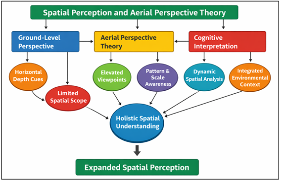
Figure 1 Spatial Perception and Aerial Perspective Theory in Drone-Based Landscape Visualization
These manipulations generate various spatial meanings of the same landscape, which allow the artist to experiment with both macro-level structural environments and micro-level visual textures. Moreover, aerial shots change the thinking process of the viewer about landscape photography.
3.3. Visual Composition Principles in Drone Cinematography
Visual composition in drone photography is based on the traditional customs of art but it brings in the exceptional handling that aerial imaging system offers. The traditional methods of composition like framing, symmetry, contrast and leading lines are still fundamental in organizing the scenes that are aesthetically appealing. Nevertheless, the drone technology adds more compositional opportunities in the form of vertical motion, rotational camera angles, and continuously moving space. These characteristics enable artists to create dynamic visual stories which develop as a result of motion and change of perspectives. Among the greatest composition benefits of drone cinematography, it is possible to investigate various perspectives in a single shot. Top-down views are more focused on geometrical forms of landscape, whereas equinus oblique views are more focused on depth and scale of the environment. The camera movements are smooth, e.g. forward tracking, circling around focal points, or changing the altitude, providing fluid changes that increase the feeling of immersion in the viewer. Cinematic effects make this artwork turn the unchanging scenery into an aesthetic artistic and narrative experience that blends artistic and spatial narration.
4. Challenges and Ethical Considerations
4.1. Regulatory constraints on drone operations
The growth of drones applications in visual arts and cinematography has brought about significant regulatory factors that impact on the manner and location in which the aerial filming may be carried out. Aviation regulators and governments worldwide have developed policies that can guarantee safe and responsible operation of drones. Such rules usually cover factors like flight altitude, restricted airspace, operator certification and safety measures to ensure that they do not interfere with the manned aircrafts or other sensitive infrastructure. Figure 2 indicates regulatory controls, safety regulations and lawful limits regarding the use of drones. In most places, drone pilots are required to seek formal approvals or licenses to fly aerial before making a film especially in densely populated areas or close to airports, government installations or conserved natural parks.
Figure 2
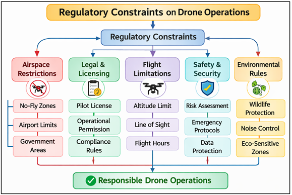
Figure 2 Regulatory Constraints Governing Drone Operations in Aerial Cinematography
These regulatory restrictions may affect the planning and implementation of landscape filming projects to artists and filmmakers working with drone cinematography. Some scenic locations can limit drone flights due to a high level of strict regulation of the national parks, heritage sites, and wildlife reserves to preserve the ecological systems and security of visitors.
4.2. Environmental and Privacy Considerations
Though drone-based cinematography promotes substantial creative possibilities, it also introduces some environmental and ethical issues that should be given serious attention by artists and researchers. One of these considerations is associated with the fact that natural ecosystems might be disrupted. Drones can pose as a danger to birds and other animals and cause stress or disturbance in the normal operations such as nesting and migration. Thus, the safe use of drones should involve a proper choice of the site, correct flight ranges, and stay out of the ecologically vulnerable regions. The other urgent problem is related to the privacy and the ethical responsibility in taking aerial photos. Drone cameras with high resolution can capture detailed visual images at relatively high distances, and as such will capture confidential property and people without their permission. It is under such circumstances that questions arise with regard to personal privacy, surveillance and data protection. Ethical aerial filming will thus include consideration of the privacy envelops and observation of the law regarding capture of images in public and private areas. In order to alleviate these fears, most practitioners in the field of art implement ethical principles that focus on transparency, environmental awareness and responsible creativity. Artists can balance the principles of social responsibility and technological innovation by applying some ethical considerations into drone-based projects.
4.3. Technical Limitations in Aerial Cinematography
Despite the fact that drone technology has revolutionized the aerial cinematography, there are various technical constraints which still affect the quality and practice of drone-based visual production. The difficulty associated with one of the major issues concerns flight duration. Consumer and professional drones are based on battery-powered systems (most), with flight times usually limited, ranging from twenty to forty minutes per battery cycle. This limitation dictates that the flight routes and filming shots must be well planned to allow maximum efficiency in case of aerial work. The weather is also a significant factor that defines the success of the drone cinematography. The slightest wind turbulence can also cause undesirable motion or vibration which lowers the image quality and cinema fluidity. Due to this, aerial filming would tend to have close observances of weather conditions and forecasts prior to shooting. The other technical constraint will be signal transmission and positioning accuracy. On the drones with a complicated topography or thick vegetation cover, communication between the control system and the drone might be compromised and as a result, flight stability and real-time video transmission may be affected.
4.4. Results and Discussion
The discussion shows that drone cinematography is the one that opens the aesthetic possibilities of landscape visual arts to a great extent by allowing using the perspectives that can hardly be obtained with the help of ordinary ground-based visual imaging. Aerial angle perspectives show extensive spatial patterns including river systems, agricultural geometry, coastal formations, as well as changes in terrain elevation and increase the visual complexity and artistic interpretation. Constantly changing camera effects, which incorporate vertical movements, panoramic shots, and tracking shots, add to vivid visual descriptions of the visuals that focus on size, depth, and the arrangement of the environment. The analysis further reveals that aerial views convert the banal landscapes to visual abstractions through emphasis of symmetry, textures, and geometries of nature. Nevertheless, operational considerations like regulatory limits, environmental sensitivity, and technical constraints are to be keenly taken care of in order to have a responsible artistic practice. On the whole, drone cinematography is a strong creative tool that enables the reinterpretation of scenery by offering new visual ways of seeing it.
Table 2
|
Table 2 Comparative Evaluation of Landscape Aesthetic Features: Traditional vs Drone Cinematography |
|||
|
Aesthetic Parameter |
Traditional Ground Imaging (%) |
Drone-Based Cinematography (%) |
Improvement (%) |
|
Visual Depth Perception |
62.4 |
88.6 |
41.9 |
|
Spatial Pattern Visibility |
55.7 |
90.2 |
61.9 |
|
Landscape Scale Representation |
58.9 |
92.5 |
57.1 |
|
Viewer Immersion Level |
60.1 |
91.8 |
52.7 |
As can be seen in Table 2, drone-based cinematography significantly outperforms conventional ground-based imaging in all of the aesthetic parameters considered in landscape visual arts. The visual depth perception is enhanced by 62.4 to 88.6, and it means that aerial point of view offers a better three-dimensional awareness and better spatial layering to the scene captured. Figure 3 demonstrates that there are drastic changes in the landscape aesthetics with the help of drone cinematography.
Figure 3
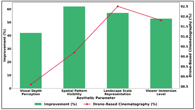
Figure 3 Improvement in Aesthetic Perception Metrics with Drone-Based Cinematography
The greatest enhancement is recorded on spatial pattern visibility, where it increases by 55.7 percent to 90.2 percent and this fact supports the idea of drone views being the most useful views in revealing natural geometries, textures, and other environmental setups of a large scale that would have been partially concealed when the viewer is on the ground. Figure 4 presents a comparison of aesthetic performance of traditional imaging and drone cinematography.
Figure 4
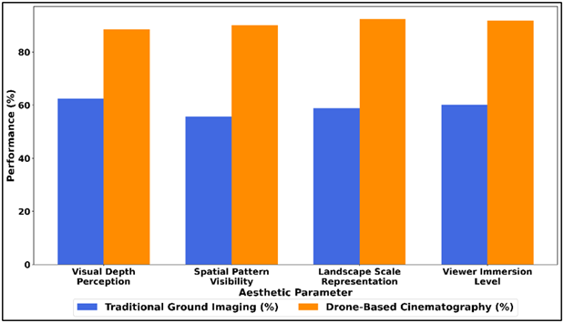
Figure 4 Comparative Analysis of Traditional Ground Imaging and Drone-Based Cinematography Across Aesthetic Parameters
The percentage of landscape scale depiction also increases significantly, 58.9 to 92.5, which explains the fact that drone imaging can record the extent and structural magnitude of natural habitats in a better way. In the same manner, the level of viewer immersion increases (60.1 to 91.8) with dynamic aerial framing and motion, implying that the visual experience with dynamic framing and motion is more interesting and emotionally captivating.
Table 3
|
Table 3 Quantitative Analysis of Aerial Cinematography Performance Across Landscape Types |
||||
|
Landscape Type |
Mean Visual Impact Score (%) |
Camera Motion Smoothness (%) |
Spatial Pattern Recognition (%) |
Viewer Engagement Rate (%) |
|
Mountain Landscapes |
90.3 |
88.1 |
85.6 |
92.4 |
|
Coastal Landscapes |
92.6 |
90.7 |
87.3 |
94.1 |
|
River Systems |
88.4 |
86.5 |
89.2 |
90.6 |
|
Agricultural Landscapes |
86.7 |
84.9 |
91.5 |
88.8 |
Table 3 is a quantitative comparison of the aerial cinematography performance in various landscape settings. The findings show that the coastal scenery has the best overall performance as the average visual impact score is 92.6 percent, and the percentage of viewers engagement is 94.1 percent. Figure 5 demonstrates landscape differences that affect spatial pattern perception and viewer. This implies that oceanic settings offer visual dynamic components like water flow, coast lines textures and horizon texture that effectively augment aerial movie worth.
Figure 5
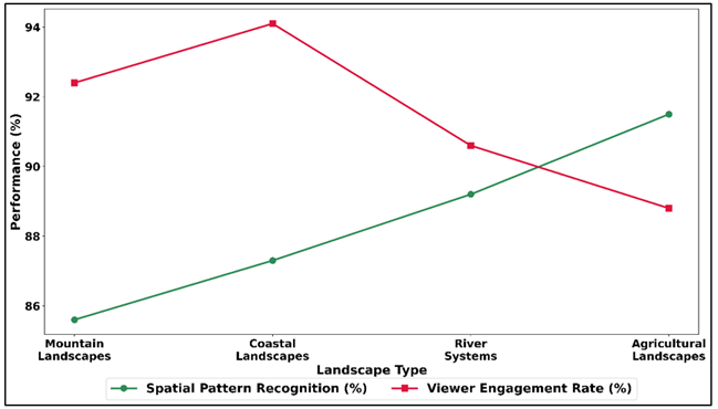
Figure 5 Spatial Pattern Recognition and Viewer Engagement Trends in Different Landscape Environments
Strong performance is also exhibited in mountain landscapes with a visual impact score of 90.3% and high viewer engagement of 92.4% being influenced to a large extent by dramatic differences in elevation and the large spatial depth which is visible through aerial shots. River systems exhibit a minor reduction of visual effect (88.4) but a high spatial pattern recognition of 89.2 that indicate the evident visibility of winding river systems and its adjacent terrain pattern pattern in the aerial view.
5. Conclusion
Drone cinematography is proving to be a radical invention in the modern visual arts of landscape, providing new points of view and compositional opportunities that are no longer limited to the conventional visual means of creative expression. This paper has examined the theoretical, pedagogical and practical aspects of applying drone technology to broaden the aesthetic depiction of natural landscapes. The results indicate that aerial imaging allows artists and film-makers to document the landscapes as seen at a high point of view and therefore bring into view, spatial arrangement, environmental forms and visual associations that cannot be easily observed when one is at ground level. Drones cinematography with aerial view, camera control movement, and high-resolution imaging can better be used to visual storytelling and aesthetic exploration in landscape art. Top-down shots, captive panoramas, and dynamic movements sequences make artists be able to take familiar surroundings and re-examine them with a unique approach. Such methods do not only focus on the size and on the depth of space but also on the geometric forms and on the textures of the environment which help create visually stimulating compositions. Although these art benefits are evident, the paper also presents some of the issues related to a drone-based visual production. The regulatory systems on the usage of the airspace must be closely observed and environmental and privacy issues must be addressed with responsible operational practices. Other potential technical reasons that may impact aerial cinematography projects include poor battery life, weather sensitivity, and low signal transmission capabilities.
CONFLICT OF INTERESTS
None.
ACKNOWLEDGMENTS
None.
REFERENCES
Bayomi, N., and Fernandez, J. E. (2023). Eyes in the Sky: Drones Applications in the Built Environment Under Climate Change Challenges. Drones, 7(10), 637. https://doi.org/10.3390/drones7100637
Cao, Z., Kooistra, L., Wang, W., Guo, L., and Valente, J. (2023). Real-Time Object Detection Based on UAV Remote Sensing: A Systematic Literature Review. Drones, 7(10), 620. https://doi.org/10.3390/drones7100620
Dronova, I., Kislik, C., Dinh, Z., and Kelly, M. (2021). A Review of Unoccupied Aerial Vehicle use in Wetland Applications: Emerging Opportunities in Approach, Technology, and Data. Drones, 5(2), 45. https://doi.org/10.3390/drones5020045
Gholami, A. (2024). Exploring Drone Classifications and Applications: A Review. International Journal of Engineering Geoscience, 9(4), 418–442. https://doi.org/10.26833/ijeg.1428724
Guan, S., Zhu, Z., and Wang, G. (2022). A Review on UAV-Based Remote Sensing Technologies for Construction and Civil Applications. Drones, 6(5), 117. https://doi.org/10.3390/drones6050117
İnan, A. T., and Ceylan, M. (2024). Aerodynamic Analysis of Fixed-Wing Unmanned Aerial Vehicles Moving in Swarm. Applied Sciences, 14(15), 6463. https://doi.org/10.3390/app14156463
Librán-Embid, F., Klaus, F., Tscharntke, T., and Grass, I. (2020). Unmanned Aerial Vehicles for Biodiversity-Friendly Agricultural Landscapes: A Systematic Review. Science of the Total Environment, 732, 139204. https://doi.org/10.1016/j.scitotenv.2020.139204
Lockhart, K., Sandino, J., Amarasingam, N., Hann, R., Bollard, B., and Gonzalez, F. (2025). Unmanned Aerial Vehicles for Real-Time Vegetation Monitoring in Antarctica: A Review. Remote Sensing, 17(2), 304. https://doi.org/10.3390/rs17020304
Lu, T., Wan, L., Qi, S., and Gao, M. (2023). Land Cover Classification of UAV Remote Sensing Based on Transformer-CNN Hybrid Architecture. Sensors, 23(11), 5288. https://doi.org/10.3390/s23115288
Mohsan, S. A. H., Khan, M. A., Noor, F., Ullah, I., and Alsharif, M. H. (2022). Towards the Unmanned Aerial Vehicles (UAVs): A Comprehensive Review. Drones, 6(6), 147. https://doi.org/10.3390/drones6060147
Raj, D. F. (2025). Comparative Evaluation of CNN-Autoencoder with Existing Models for Security Threat Detection in Cloud Environments. International Journal of Advanced Computer Engineering and Communication Technology, 14(2), 71–83.
Sharma, H., Sidhu, H., and Bhowmik, A. (2025). Remote Sensing Using Unmanned Aerial Vehicles for Water Stress Detection: A Review Focusing on Specialty Crops. Drones, 9(4), 241. https://doi.org/10.3390/drones9040241
Sun, Z., Wang, X., Wang, Z., Yang, L., Xie, Y., and Huang, Y. (2021). UAVs as Remote Sensing Platforms in Plant Ecology: Review of Applications and Challenges. Journal of Plant Ecology, 14(6), 1003–1020. https://doi.org/10.1093/jpe/rtab089
Yucesoy, E., Balcik, B., and Coban, E. (2025). The Role of Drones in Disaster Response: A Literature Review of Operations Research Applications. International Transactions in Operational Research, 32(2), 545–589. https://doi.org/10.1111/itor.13484
|
|
 This work is licensed under a: Creative Commons Attribution 4.0 International License
© ShodhKosh 2026. All Rights Reserved.